Great Barrier Island lies in the outer Hauraki Gulf, New Zealand, 100 kilometres (62 mi) north-east of central Auckland. With an area of 285 square kilometres (110 sq mi) it is the sixth-largest island of New Zealand and fourth-largest in the main chain. Its highest point, Mount Hobson, is 627 metres (2,057 ft) above sea level. The local authority is the Auckland Council.

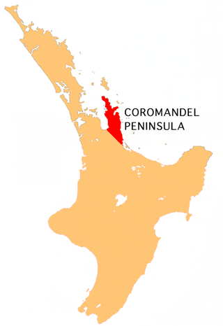
The Hauraki Gulf / Tīkapa Moana is a coastal feature of the North Island of New Zealand. It has an area of 4000 km2, and lies between, in anticlockwise order, the Auckland Region, the Hauraki Plains, the Coromandel Peninsula, and Great Barrier Island. Most of the gulf is part of the Hauraki Gulf Marine Park.

Muriwai, also called Muriwai Beach, is a coastal community on the west coast of the Auckland Region in the North Island of New Zealand. The black-sand surf beach and surrounding area is a popular recreational area for Aucklanders. The Muriwai Regional Park includes a nesting site for a large colony of gannets.
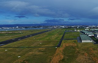
Tauranga Airport is an airport serving the city of Tauranga, New Zealand. It is located adjacent to Tauranga Harbour in the suburb of Mount Maunganui, approximately 3 km northeast of Tauranga CBD. The terminal is located to the north of the runway, on Jean Batten Drive, and consists of a two-storey building with four tarmac gates. Air New Zealand serves the airport through its subsidiaries Mount Cook Airline and Air Nelson, with flights to Auckland, Wellington and Christchurch. A further two regional airlines also operate to the airport, as well as scenic and charter flights, skydiving operations and general aviation.

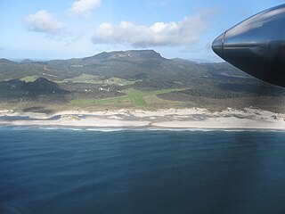
Great Barrier Aerodrome is the major airfield on Great Barrier Island. It is a small, non-towered aerodrome at Claris on Great Barrier Island in the Hauraki Gulf off the North Island of New Zealand. Fuel is not available.
Fly My Sky was a small airline based in Auckland, New Zealand. It operated between Auckland, Matamata and Great Barrier Island. The airline went into liquidation at the end of June 2021. The airline evolved out of the now also defunct Mountain Air.
Barrier Air is a New Zealand airline that was established in 1983 by Jim Bergman as Great Barrier Airlines. The head office is located at the Domestic Terminal at Auckland Airport in Māngere, with additional offices in the terminal buildings at Great Barrier Aerodrome, Kaitaia Airport and North Shore Aerodrome.

Windy Canyon is a canyon and associated walking track on Great Barrier Island, New Zealand. Located in the centre east of the island, the canyon is a wind funnel shaped from andesitic rock. The canyon is located on one of the highest stretches of the island, less than 200 m below the 621 m summit of Mount Hobson. From the canyon it is possible to view the Okiwi and Awana lowlands.
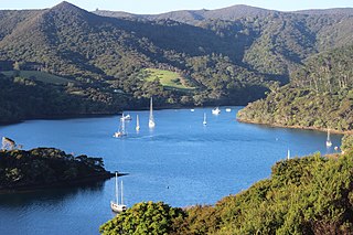
Port Fitzroy is a harbour and coastal community on Great Barrier Island in New Zealand's Hauraki Gulf.

Harataonga Bay is a coastal feature and area on the northeast coast of Great Barrier Island in New Zealand's Hauraki Gulf, approximately 51 nautical miles northeast of central Auckland. Most of the area is in the Harataonga Recreation Reserve, with some of the hinterland forming the Harataonga Scenic Reserve.
Okiwi Airfield, also called Okiwi Station Airfield, is a small airfield located near the village of Ōkiwi on Great Barrier Island, New Zealand. It has a single bitumen runway, and a small terminal in the form of a wooden hut. The airfield is owned by Auckland Council and is used for general aviation.
Air Auckland was a small airline based at Ardmore Airport in New Zealand. The company is a fixed-wing and CAA part 135 air operator that offers flight services including regular flights to Whitianga and Great Barrier Island.

Medlands Beach is in Oruawharo Bay on the east coast of Great Barrier Island in the Auckland Region of New Zealand. Auckland Council describes it as the most accessible beach on the island. It is one of the island's main tourist areas but is little developed. The small settlement of Medlands consists of permanent houses and holiday baches, some behind the dunes, sheltered from winds from the sea, and others elevated for a view.
Claris is a settlement on the east coast of Great Barrier Island in the Auckland Region of New Zealand. Though less populous than the main seaport area of Tryphena on the west coast, Claris functions as the administrative centre for the island, and a large proportion of its commercial and community services are based there.
Awana Bay is a beach on the east coast of Great Barrier Island in the Hauraki Gulf of New Zealand's Auckland Region. The beach is used by both swimmers and surfers alike. It is deep-sloping, with a risk of both strong waves and rip currents. There are several peaks for intermediate to expert surfers, including a good left-hander at the northern end and a good left-hander at the southern end.
Ōkiwi is a small settlement and rural community at the head of the Whangapoua Estuary, in Whangapoua Bay, on Great Barrier Island in New Zealand's Hauraki Gulf.

Whangapoua Beach is on the east coast of Great Barrier Island in New Zealand's Hauraki Gulf. The beach runs roughly north–south and has views of Rakitu Island. The Whangapoua Creek drains large estuarine wetlands and enters the sea at the southern end of the beach.

Whangaparapara is a harbour and coastal community on Great Barrier Island in New Zealand's Hauraki Gulf.
Palmers Beach is on the east coast of Great Barrier Island in New Zealand's Hauraki Gulf.