
Katherine Bay, alternatively spelt as Catherine Bay, is a bay located on the northwestern coast of Great Barrier Island, New Zealand. [1] [2] The bay was named in 1870 by Captain Nagle after his wife. [3]
Katherine Bay, alternatively spelt as Catherine Bay, is a bay located on the northwestern coast of Great Barrier Island, New Zealand. [1] [2] The bay was named in 1870 by Captain Nagle after his wife. [3]
The area around the bay was originally inhabited by Ngapuhi Māori since 1660. [3]
During the early Colonial era of New Zealand in the mid-19th century extensive private and crown land purchases lead to only two areas of the Hauraki Gulf remained in Māori ownership: Te Huruhi (Surfdale) on Waiheke Island (2100 acres) and a 3,510 acre parcel of land at Katherine Bay on Great Barrier Island. [4]
In the August of 1937 Dr C. B. Gilbard and Mr. W. Armour reported a typhoid epidemic in a native settlement in Katherine Bay which had claimed the lives of three Māori adults and a child. [5]

Great Barrier Island lies in the outer Hauraki Gulf, New Zealand, 100 kilometres (62 mi) north-east of central Auckland. With an area of 285 square kilometres (110 sq mi) it is the sixth-largest island of New Zealand and fourth-largest in the main chain. Its highest point, Mount Hobson, is 627 metres (2,057 ft) above sea level. The local authority is the Auckland Council.
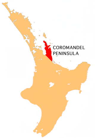
The Coromandel Peninsula on the North Island of New Zealand extends 85 kilometres (53 mi) north from the western end of the Bay of Plenty, forming a natural barrier protecting the Hauraki Gulf and the Firth of Thames in the west from the Pacific Ocean to the east. It is 40 kilometres (25 mi) wide at its broadest point. Almost its entire population lives on the narrow coastal strips fronting the Hauraki Gulf and the Bay of Plenty. In clear weather the peninsula is clearly visible from Auckland, the country's biggest city, which lies on the far shore of the Hauraki Gulf, 55 kilometres (34 mi) to the west. The peninsula is part of the Thames-Coromandel District and the Waikato Region.

Te Motu Kairangi / Miramar Peninsula is a large peninsula on the southeastern side of the city of Wellington, New Zealand. It is located at the entrance to Wellington Harbour, in Wellington's eastern suburbs. According to Māori legend, it was formed when the taniwha Whaitaitai beached as he tried to escape the confines of the harbour. It contains the suburbs of Miramar, Seatoun, Strathmore Park, and Karaka Bays.

Moturoa / Rabbit Island is a small island that lies across the southernmost part of Tasman Bay / Te Tai-o-Aorere, on the northern coast of New Zealand's South Island. The long narrow island runs east–west for 8 kilometres (5 mi), and covers 15 km2 (5.8 sq mi).

Matakana Island is located in the western Bay of Plenty in New Zealand's North Island. A long, flat barrier island, it is 20 kilometres (12 mi) in length but rarely more than 3 kilometres (1.9 mi) wide. The island has been continuously populated for centuries by Māori tribes that are mostly associated with Ngāi Te Rangi.

Mercury Bay is a large V-shaped bay on the eastern coast of the Coromandel Peninsula on the North Island of New Zealand. It was named by the English navigator Captain James Cook during his exploratory expeditions. It was first named Te-Whanganui-a-Hei, the great bay of Hei, by the Māori.

Blockhouse Bay is a residential suburb in the south west of Auckland, in New Zealand's North Island. It is sited on the northern coast of the Manukau Harbour, and is also close to the administrative boundary that existed between Auckland City and Waitakere City, two of the former four cities of what was the Auckland conurbation before amalgamation into Auckland Council.

Tini "Whetu" Marama Tirikatene-Sullivan was a New Zealand politician. She was an MP from 1967 to 1996, representing the Labour Party and was New Zealand’s first Māori woman cabinet minister. At the time of her retirement, she was the second longest-serving MP in Parliament, being in her tenth term of office. She was one of twenty holders of the Order of New Zealand, the highest honour of the country.

Thorndon is a historic inner suburb of Wellington, the capital city of New Zealand. Because the suburb is relatively level compared to the hilly terrain elsewhere in Wellington it contained Wellington's elite residential area until its best was destroyed in the 1960s by a new motorway and the erection of tall office buildings on the sites of its Molesworth Street retail and service businesses.

SS Wairarapa was a New Zealand ship of the late 19th century plying the route between Auckland, New Zealand and Australia. It came to tragic fame when it hit a reef at the northern edge of Great Barrier Island, about 100 km out from Auckland, and sank. The death toll of around 130 people remains one of the largest such losses in the country's history. The ship was named for the Wairarapa region.
Mairangi Bay is a coastal suburb of North Shore, Auckland, located in the northern North Island of New Zealand, on the south-east-facing peninsula forming the northern side of the Waitematā Harbour. Mairangi Bay came under the local governance of the North Shore City Council until subsumed into the Auckland Council in 2010.
The Māori protest movement is a broad indigenous rights movement in New Zealand. While there was a range of conflicts between Māori and European immigrants prior to the signing of the Treaty of Waitangi in 1840, the signing provided one reason for protesting. Disagreements in the decades following the signing sometimes included war.
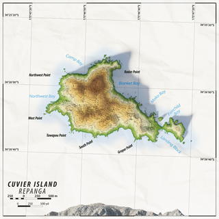
Cuvier Island is a small uninhabited island off the east coast of the North Island of New Zealand. It lies on the seaward end of the Colville Channel, 15 km (9.3 mi) north of the Mercury Islands and approximately 23 km (14 mi) south-east of Great Barrier Island. The 195 ha island is a wildlife sanctuary, managed by the Department of Conservation and is the subject of an ongoing island restoration project to eliminate non-native mammals and restore the original ecosystem. It is also the location of the Cuvier Island Lighthouse which was constructed in 1889 and the wreck of the old HMNZS Philomel which was scuttled near the island on 6 August 1949 after decommissioning and being stripped of useful equipment.

Ngāti Pūkenga is a Māori iwi centred in Tauranga in the Bay of Plenty region of New Zealand. Its rohe extends to Mayor Island / Tuhua and Waihi in the north, to the Kaimai Range in the west, south of Te Puke and to Maketu in the east, and it has tribal holdings in Whangarei, Hauraki and Maketu.
Southern Maori was one of New Zealand's four original parliamentary Māori electorates established in 1868, along with Eastern Maori, Western Maori and Eastern Maori. In 1996, with the introduction of MMP, the Maori electorates were updated, and Southern Maori was replaced with the Te Tai Tonga and Te Puku O Te Whenua electorates.
The 1993 New Zealand rugby league season was the 86th season of rugby league that had been played in New Zealand. The main feature of the year was the National Provincial Championship competition that was run by the New Zealand Rugby League. Canterbury won the Championship by defeating Auckland 36–12 in the Final.
Motairehe is a settlement located in Katherine Bay, on the northwestern coast Great Barrier Island, New Zealand. The marae Motairehe Marae and its Whakaruruhau meeting house which are affiliated with Ngātiwai Ki Aotea are located here.

Ōkiwi Bay is a small town in the Marlborough Sounds, New Zealand, within Croisilles Harbour. It has about 200 houses and about 80 permanent residents. The area was noted for its oysters.
Ōkiwi is a small settlement and rural community at the head of the Whangapoua Estuary, in Whangapoua Bay, on Great Barrier Island in New Zealand's Hauraki Gulf.
Pura McGregor, also known as Pura Makarika, was a community leader in Whanganui, New Zealand, and the first Māori woman to receive an MBE.
{{cite book}}: Unknown parameter |agency= ignored (help)