
Great Barrier Island lies in the outer Hauraki Gulf, New Zealand, 100 kilometres (62 mi) north-east of central Auckland. With an area of 285 square kilometres (110 sq mi) it is the sixth-largest island of New Zealand and fourth-largest in the main chain. Its highest point, Mount Hobson, is 627 metres (2,057 ft) above sea level. The local authority is the Auckland Council.

The national parks of New Zealand are protected natural areas administered by the Department of Conservation (DOC). The first national parks established in the country were all focused on mountain scenery. Since the 1980s the focus has been on developing a more diverse representation of New Zealand landscapes. The parks are all culturally significant and many also contain historic features. Tongariro National Park is one of the World Heritage Sites that are of both cultural and natural significance, while four of the South Island national parks form Te Wahipounamu, another World Heritage Site. There are currently 13 national parks; a 14th, Te Urewera National Park, was disestablished in 2014.
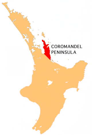
The Coromandel Peninsula on the North Island of New Zealand extends 85 kilometres (53 mi) north from the western end of the Bay of Plenty, forming a natural barrier protecting the Hauraki Gulf and the Firth of Thames in the west from the Pacific Ocean to the east. It is 40 kilometres (25 mi) wide at its broadest point. Almost its entire population lives on the narrow coastal strips fronting the Hauraki Gulf and the Bay of Plenty. In clear weather the peninsula is clearly visible from Auckland, the country's biggest city, which lies on the far shore of the Hauraki Gulf, 55 kilometres (34 mi) to the west. The peninsula is part of the Thames-Coromandel District and the Waikato Region.

Kaipara Harbour is a large enclosed harbour estuary complex on the north western side of the North Island of New Zealand. The northern part of the harbour is administered by the Kaipara District and the southern part is administered by the Auckland Council. The local Māori tribe is Ngāti Whātua.

The Mercury Islands are a group of seven islands off the northeast coast of New Zealand's North Island. They are located 8 kilometres (5 mi) off the coast of the Coromandel Peninsula, and 35 kilometres (22 mi) northeast of the town of Whitianga.
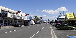
Whitianga is a town on the Coromandel Peninsula, in the Waikato region of New Zealand's North Island. The town is located on Mercury Bay, on the northeastern coast of the peninsula. The town has a permanent population of 6,440 as of June 2023, making it the second-largest town on the Coromandel Peninsula behind Thames.

Whatipu is a remote beach on the west coast of the Auckland Region in the North Island of New Zealand. The Whatipu area has been managed as a scientific reserve by the Auckland Regional Council since 2002. The road to it is unsealed. To the south of Whatipu is Manukau Harbour. To the north is Karekare. Whatipu is located at the southern end of the Waitākere Ranges. Shifting sands have substantially changed the beach since the 1940s. Over 6 square kilometres has been added to the beach since then.
Port Fitzroy is a harbour and coastal community on Great Barrier Island in New Zealand's Hauraki Gulf.

Whangaroa Harbour, previously spelled Wangaroa Harbour, is an inlet on the northern coast of Northland, New Zealand. Whangaroa Bay and the Pacific Ocean are to the north. The small settlements of Totara North and Saies are on the west side of the harbour, Waitaruke on the south side, and Whangaroa on the east. State Highway 10 runs through Waitaruke. The name comes from the lament "Whaingaroa" or "what a long wait" of a woman whose warrior husband had left for a foray to the south. The harbour was formed when rising sea levels drowned a river valley about 6,000 years ago. Steep outcrops remain from ancient volcanic rocks.

The Manaia River is a river of the Coromandel Peninsula in New Zealand's North Island. It flows north from its sources in the Coromandel Range, reaching the Hauraki Gulf at Manaia Harbour, 10 kilometres (6 mi) southwest of Coromandel.
The Waitawheta River is a river of the Waikato Region of New Zealand's North Island. It flows from a point south-east of Mount Te Aroha in the Kaimai Range to the Karangahake Gorge at the foot of the Coromandel Peninsula to reach the Ohinemuri River at Karangahake, five kilometres east of Paeroa.

Cape Brett Peninsula is a 15 km (9.3 mi) long peninsula in the Bay of Islands, in the Northland Region of New Zealand.

Harataonga Bay is a coastal feature and area on the northeast coast of Great Barrier Island in New Zealand's Hauraki Gulf, approximately 51 nautical miles northeast of central Auckland. Most of the area is in the Harataonga Recreation Reserve, with some of the hinterland forming the Harataonga Scenic Reserve.
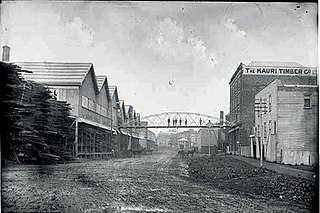
The Kauri Timber Company, Limited (KTC) Auckland was from 1888 to 1971 a large logging and sawmilling company in New Zealand.

Aotea Conservation Park is a 12,300 hectare protected area on Great Barrier Island in New Zealand's Hauraki Gulf. It was established in 2015, and comprises 43 percent of the island.

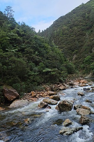
Kauaeranga Valley is a valley created by the Kauaeranga River, which flows from the Coromandel Range southwest to the Firth of Thames at Thames, New Zealand in the North Island. It contains the settlement of Kauaeranga on the Coromandel Peninsula. It is located near Thames, in the Thames-Coromandel District in the Waikato region. It covers a land area of 180.51 km2.
Maratoto is a valley and rural community in the Hauraki District and Waikato region of New Zealand's North Island, north of Paeroa.
Awana Bay is a beach on the east coast of Great Barrier Island in the Hauraki Gulf of New Zealand's Auckland Region. The beach is used by both swimmers and surfers alike. It is deep-sloping, with a risk of both strong waves and rip currents. There are several peaks for intermediate to expert surfers, including a good left-hander at the northern end and a good left-hander at the southern end.
Ōkiwi is a small settlement and rural community at the head of the Whangapoua Estuary, in Whangapoua Bay, on Great Barrier Island in New Zealand's Hauraki Gulf.

Whangapoua Beach is on the east coast of Great Barrier Island in New Zealand's Hauraki Gulf. The beach runs roughly north–south and has views of Rakitu Island. The Whangapoua Creek drains large estuarine wetlands and enters the sea at the southern end of the beach.
