
The North Island, also officially named Te Ika-a-Māui, is one of the two main islands of New Zealand, separated from the larger but much less populous South Island by the Cook Strait. The island's area is 113,729 square kilometres (43,911 sq mi), making it the world's 14th-largest island. It has a population of 3,925,800, accounting for approximately 77% of the total residents of New Zealand.

The Taupō Volcanic Zone (TVZ) is a volcanic area in the North Island of New Zealand that has been active for the past two million years and is still highly active. Mount Ruapehu marks its south-western end and the zone runs north-eastward through the Taupō and Rotorua areas and offshore into the Bay of Plenty. It is part of the larger Central Volcanic Region that extends further westward through the western Bay of Plenty to the eastern side of the Coromandel Peninsula and has been active for four million years. The Taupō Volcanic Zone is widening east–west at the rate of about 8 mm per year. It is named after Lake Taupō, the flooded caldera of the largest volcano in the zone, the Taupō Volcano.

The Kaimai Range is a mountain range in the North Island of New Zealand. It is part of a series of ranges, with the Coromandel Range to the north and the Mamaku Ranges to the south. The Kaimai Range separates the Waikato in the west from the Bay of Plenty in the east.

Coromandel, also called Coromandel Town to distinguish it from the wider district, is a town on the Coromandel Harbour, on the western side of the Coromandel Peninsula, which is in the North Island of New Zealand. It is 75 kilometres east of the city of Auckland, although the road between them, which winds around the Firth of Thames and Hauraki Gulf coasts, is 190 km long. The population was 1,890 as of June 2021.

Waiheke Island is the most populated and the second-largest island in the Hauraki Gulf of New Zealand. Its ferry terminal in Matiatia Bay at the western end is 21.5 km (13.4 mi) from the central-city terminal in Auckland.
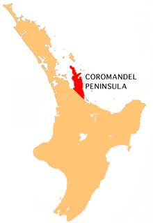
The Coromandel Peninsula on the North Island of New Zealand extends 85 kilometres (53 mi) north from the western end of the Bay of Plenty, forming a natural barrier protecting the Hauraki Gulf and the Firth of Thames in the west from the Pacific Ocean to the east. It is 40 kilometres (25 mi) wide at its broadest point. Almost its entire population lives on the narrow coastal strips fronting the Hauraki Gulf and the Bay of Plenty. In clear weather the peninsula is clearly visible from Auckland, the country's biggest city, which lies on the far shore of the Hauraki Gulf, 55 kilometres (34 mi) to the west. The peninsula is part of the Thames-Coromandel District of the Waikato region.
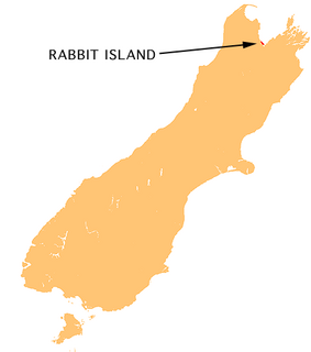
Moturoa / Rabbit Island is a small island that lies across the southernmost part of Tasman Bay / Te Tai-o-Aorere, on the northern coast of New Zealand's South Island. The long narrow island runs east–west for 8 kilometres (5 mi), and covers 15 km2 (5.8 sq mi).

Mercury Bay is a large V-shaped bay on the eastern coast of the Coromandel Peninsula on the North Island of New Zealand. It was named by the English navigator Captain James Cook during his exploratory expeditions. It was first named Te-Whanganui-a-Hei, the great bay of Hei, by the Māori.
Whitianga is a town on the Coromandel Peninsula, in the Waikato region of New Zealand's North Island. The town is located on Mercury Bay, on the northeastern coast of the peninsula. The town has a permanent population of 6,330 as of June 2021, making it the second-largest town on the Coromandel Peninsula behind Thames.

Blockhouse Bay, commonly known as the Bay Area, is a residential suburb in the south west of Auckland, in New Zealand's North Island. It is sited on the northern coast of the Manukau Harbour, and is also close to the administrative boundary that existed between Auckland City and Waitakere, two of the former four cities of what was the Auckland conurbation before amalgamation into Auckland Council.

Whangaparaoa Peninsula or Whangaparāoa Peninsula is a suburban area about 25 km north of Auckland, New Zealand. It had 30,672 residents in 2013, many of them in the eponymous town of Whangaparaoa on its southern side. It is part of the Hibiscus Coast.

Maketu is a small town on the Bay of Plenty Coast in New Zealand.

Ostend is a settlement on Waiheke Island, in New Zealand's Hauraki Gulf within the Auckland Region. Ostend is located in the west of the island, on and around a small peninsula which juts into Putiki Bay, one of two large indentations in the island's southwest coast. The southwest of the island contains much of the island's population, with Ostend being located immediately to the east of the settlement of Surfdale, and to the southwest of Onetangi.

Hahei is a small settlement in Mercury Bay on the eastern side of the Coromandel Peninsula in New Zealand. It is near Cathedral Cove, between the settlements of Cooks Beach and Hot Water Beach. It is approximately 11 km south east of Whitianga and 8 km north of Hot Water Beach.

Cuvier Island is a small uninhabited island off the east coast of the North Island of New Zealand. It lies on the seaward end of the Colville Channel, 15 km (9.3 mi) north of the Mercury Islands and approximately 23 km (14 mi) south-east of Great Barrier Island. The 195 ha island is a wildlife sanctuary, managed by the Department of Conservation and is the subject of an ongoing island restoration project to eliminate non-native mammals and restore the original ecosystem. It is also the location of the Cuvier Island Lighthouse which was constructed in 1889 and the wreck of the old HMNZS Philomel which was scuttled near the island on 6 August 1949 after decommissioning and being stripped of useful equipment.
Kuratau is a small village north of Omori, on the western side of New Zealand's Lake Taupo. The population in the 2013 census was 273 people in 117 households; 22.0 percent of the population was under 15 and 15.4 percent were over 65. Approximately 76% of the population is of European origin and approximately 37% is of Maori origin. The most commonly spoken language is English.

Kennedy Bay is a locality in the north eastern Coromandel Peninsula of New Zealand. The Harataunga and Omoho Streams flow from the Coromandel Range past the settlement and into the bay to the east.
The Ōtoko River is a river of the West Coast Region of New Zealand's South Island. It flows generally northwest from the northern slopes of Mount Hooker, reaching the Paringa River 20 kilometres south of Bruce Bay.

Harataonga Bay is a coastal feature and area on the northeast coast of Great Barrier Island in New Zealand's Hauraki Gulf, approximately 51 nautical miles northeast of central Auckland. Most of the area is in the Harataonga Recreation Reserve, with some of the hinterland forming the Harataonga Scenic Reserve.

Onetangi is a settlement on the north coast of Waiheke Island in New Zealand. It has a long white-sand beach fronting onto Onetangi Bay.
