Rosebank, Auckland

Last updated

Rosebank
Rosebank Peninsula Seen From The East.jpg
The suburb seen over the tidal flats surrounding it on most sides
Rosebank, Auckland
Coordinates: 36°52′45″S174°40′17″E / 36.879277°S 174.671495°E / -36.879277; 174.671495
CountryNew Zealand
City Auckland
Local authority Auckland Council
Electoral ward Whau ward
Local board Whau Local Board
Area
[1]
  Land237 ha (586 acres)
Population
 (June 2023) [2]
  Total40
Te Atatū Peninsula (Waitematā Harbour)(Waitemata Harbour)
Te Atatū South
Pfeil oben.svg
Pfeil links.svgRosebankPfeil rechts.svg
Pfeil unten.svg
Waterview
Glendene Kelston Avondale

Rosebank (or the Rosebank Peninsula) is a peninsula and industrial suburb of Auckland, New Zealand. It is the westernmost point of the Auckland isthmus. The peninsula runs from the southeast in a northerly direction, with the Whau River on its west. Pollen Island and Traherne Island lie nearby in the Waitematā Harbour to the north-eastern side of the peninsula. Traherne Island is connected to the peninsula by a causeway that is part of the Northwestern Motorway.

Contents

The Northwestern Motorway cuts across the top of the peninsula, with flyover ramps connecting at Rosebank Road and Patiki Road. The Northwestern Cycleway also runs across it, parallel to the motorway. [3]

The suburb is a large employment area mainly composed of industrial (manufacturing, with some office) properties off Rosebank Road (with 813 businesses operating here in 2009). [3] There is one "open space" area, the Rosebank Park Domain in the northwest of the peninsula, almost solely used for go-karting and as a speedway (leased from Council). [3]

The Motu Manawa (Pollen Island) Marine Reserve covers all of the harbour adjacent to the north and east of the peninsula, including Pollen and Traherne Islands.

History

A number of archeological remains exist along the northern part of the peninsula, including old Maori middens, a tramway and remnants of a limeworks and early housing sites. However, most of these have been destroyed by development and past motorway construction. [3]

In 1852, Dr. Daniel Pollen opened the first brickworks in West Auckland, at Rosebank on the shores of the Whau River. [4] Pollen engaged with British potter James Wright to create the first commercial scale crockery kiln in New Zealand at the location. [4] Shells taken from the banks of Motumānawa / Pollen Island were processed at the brickworks, in order to create lime for the brick and concrete industries. [4]

Demographics

Rosebank Peninsula statistical area covers 2.37 km2 (0.92 sq mi) [1] and had an estimated population of 40 as of June 2023, [2] with a population density of 17 people per km2.

Historical population
YearPop.±% p.a.
200630    
201315−9.43%
201830+14.87%
Source: [5]

Rosebank Peninsula had a population of 30 at the 2018 New Zealand census, an increase of 15 people (100.0%) since the 2013 census, and unchanged since the 2006 census. There were 3 households, comprising 21 males and 3 females, giving a sex ratio of 7.0 males per female. The median age was 42.1 years (compared with 37.4 years nationally), with 3 people (10.0%) aged under 15 years, 6 (20.0%) aged 15 to 29, 15 (50.0%) aged 30 to 64, and 3 (10.0%) aged 65 or older.

Ethnicities were 60.0% European/Pākehā, 30.0% Asian, and 10.0% other ethnicities. People may identify with more than one ethnicity.

The percentage of people born overseas was 30.0, compared with 27.1% nationally.

Although some people chose not to answer the census's question about religious affiliation, 50.0% had no religion, 40.0% were Christian, and 20.0% were Hindu.

Of those at least 15 years old, 3 (11.1%) people had a bachelor's or higher degree, and 3 (11.1%) people had no formal qualifications. The median income was $53,900, compared with $31,800 nationally. 9 people (33.3%) earned over $70,000 compared to 17.2% nationally. The employment status of those at least 15 was that 21 (77.8%) people were employed full-time, and 3 (11.1%) were part-time. [5]

Panorama

Waitemata Harbour Eastwards View (cropped).jpg
The peninsula from the air, distinct from surrounding suburbs by the mostly white, larger commercial buildings

Sport

Rosebank Speedway is a motorcycle speedway venue located in the Rosebank Park Domain, on the Patiki Road. [6] [7] [8] The track is a significant venue for important speedway events and has held the final of the New Zealand Solo Championship in 2006, 2011, 2013, 2016 and 2019. [9]

Related Research Articles

<span class="mw-page-title-main">New Lynn</span> Suburb in Auckland, New Zealand

New Lynn is a residential suburb in West Auckland, New Zealand, located 10 kilometres to the southwest of the Auckland city centre. The suburb is located along the Whau River, one of the narrowest points of the North Island, and was the location of Te Tōanga Waka, a traditional waka portage between the Waitematā and Manukau harbours.

<span class="mw-page-title-main">Whau River</span> River in Auckland, New Zealand

The Whau River is an estuarial arm of the southwestern Waitemata Harbour within the Auckland metropolitan area in New Zealand. It flows north for 5.7 kilometres (3.5 mi) from its origin at the confluence of the Avondale Stream and Whau Stream to its mouth between the Te Atatū Peninsula and the long, thin Rosebank Peninsula in Avondale. It is 800 metres (2,600 ft) at its widest and 400 metres (1,300 ft) wide at its mouth.

<span class="mw-page-title-main">Point Chevalier</span> Suburb in Auckland, New Zealand

Point Chevalier is a residential suburb and peninsula in the city of Auckland in the north of New Zealand. It is located five kilometres to the west of the city centre on the southern shore of the Waitematā Harbour. The suburb was originally a working-class area, with some state houses in the area, but over the past several decades the suburb has seen growth into becoming a middle-class suburb, with several redevelopment projects either completed or underway. Like most of the suburbs surrounding, Point Chevalier is known for its Californian style bungalows.

<span class="mw-page-title-main">Blockhouse Bay</span> Suburb in Auckland, New Zealand

Blockhouse Bay is a residential suburb in the south west of Auckland, in New Zealand's North Island. It is sited on the northern coast of the Manukau Harbour, and is also close to the administrative boundary that existed between Auckland City and Waitakere City, two of the former four cities of what was the Auckland conurbation before amalgamation into Auckland Council.

<span class="mw-page-title-main">Whenuapai</span> Suburb in Auckland, New Zealand

Whenuapai is a suburb and aerodrome located in northwestern Auckland, in the North Island of New Zealand. It is located on the shore of the Upper Waitematā Harbour, 15 kilometres to the northwest of Auckland's city centre. It is one of the landing points for the Southern Cross telecommunications Cables.

<span class="mw-page-title-main">Kelston, New Zealand</span> Suburb in Auckland, New Zealand

Kelston is a residential suburb of West Auckland, New Zealand. Originally a ceramics manufacturing centre, the area is now mostly residential, including a number of schools. Kelston is located in, and its name has been given to, the Kelston parliamentary electorate.

<span class="mw-page-title-main">Waterview, New Zealand</span> Suburb in Auckland, New Zealand

Waterview is a suburb of Auckland, New Zealand, located along the western side of Auckland's isthmus. Its boundaries are Oakley Creek in the east, Heron Park in the south, the Waitematā Harbour in the west, and the Northwestern Motorway and the Oakley Creek inlet in the north.

<span class="mw-page-title-main">Te Atatū South</span> Suburb in Auckland, New Zealand

Te Atatū South is a residential suburb in West Auckland, New Zealand. Its location allows the suburb easy access to the city and Henderson town centre. Its elevation allows views back on to the city and Waitākere Ranges. Situated on the Te Atatū Peninsula, it has coasts backing on to water on its eastern and western sides with walkways and cycleways on both sides.

<span class="mw-page-title-main">Te Atatū Peninsula</span> Suburb in Auckland, New Zealand

Te Atatū Peninsula is a waterfront suburb of West Auckland surrounded by the Waitematā Harbour. The area was home to brickworks and farmland until the Northwestern Motorway was constructed in the 1950s, after which Te Atatū developed a low and medium-cost suburb. The area south of the motorway became known as Te Atatū South. The Auckland Harbour Board intended to develop a port on the peninsula for much of the 20th century. After plans for this were abandoned, the land was redeveloped into Footrot Flats Fun Park, an amusement park which operated in the 1980s. During the late 2010s, large-scale housing intensification led to the population of Te Atatū greatly expanding.

<span class="mw-page-title-main">Stillwater, Auckland</span> Suburb in Auckland, New Zealand

Stillwater is a village in the northern end of Auckland in the North Island of New Zealand. Situated on the Weiti River immediately south of the Whangaparaoa Peninsula in the Rodney District, it is part of the area known as the Hibiscus Coast. There is also a Stillwater, West Coast in the South Island.

<span class="mw-page-title-main">Hobsonville</span> Suburb in Auckland, New Zealand

Hobsonville is a suburb in West Auckland, in the North Island of New Zealand. The area was administered by Waitakere City Council until the council was amalgamated into Auckland Council in 2010.

<span class="mw-page-title-main">Avondale, Auckland</span> Suburb in Auckland, New Zealand

Avondale is a suburb of Auckland, New Zealand. Located on the central western Auckland isthmus. It is located in the Whau local board area, one of the 21 administrative divisions for the Auckland Council.

<span class="mw-page-title-main">Whau Valley</span> Suburb in Whangārei, New Zealand

Whau Valley is a suburb of Whangārei, in Northland Region, New Zealand. State Highway 1 runs through it. The valley was named for the whau trees which grew there in the 1850s.

<span class="mw-page-title-main">State Highway 16 (New Zealand)</span> State Highway in Auckland, New Zealand

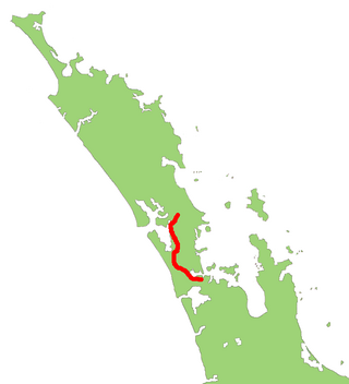
State Highway 16 is a New Zealand state highway linking central Auckland with Wellsford, via Auckland's Northwestern Motorway, Helensville and Kaukapakapa. It provides an alternative to SH 1 for traffic travelling between Auckland and parts of Northland from Wellsford northwards.

<span class="mw-page-title-main">Motu Manawa (Pollen Island) Marine Reserve</span>

Motu Manawa-Pollen Island Marine Reserve is a 501 hectares (1.93 sq mi) protected area in the Waitemata Harbour in Auckland, New Zealand, established in 1996. It includes the entire area between Rosebank Peninsula and Waterview, and surrounds Motumānawa / Pollen Island and Traherne Island. Its northeastern boundary runs roughly parallel to Rosebank Peninsula, from the mouth of the Oakley Creek estuary. Its northernmost boundary is north of Pollen Island, at the same latitude as the tip of Point Chevalier. Its westernmost point is in the mouth of the Whau River, between the tip of Rosebank Peninsula and Te Atatū. It is bisected by the Northwestern Motorway.

<span class="mw-page-title-main">Motumānawa / Pollen Island</span>

Motumānawa / Pollen Island is an island in the Waitematā Harbour, very near the northern end of Rosebank Peninsula, in Auckland, New Zealand. It is one of two islands surrounded by the Motu Manawa Marine Reserve, the other being Traherne Island. The 500 hectares (1.9 sq mi) marine reserve was established in 1995. The official name of the island was changed from Pollen Island and gazetted as Motumānawa / Pollen Island on 12 November 2015.

<span class="mw-page-title-main">Traherne Island</span>

Traherne Island is a 13 hectares (0.050 sq mi) island in the Waitematā Harbour, very near Rosebank Peninsula, in Auckland, New Zealand. It is one of two islands surrounded by the Motu Manawa Marine Reserve, the other being Pollen Island. The 500 hectares (1.9 sq mi) marine reserve was established in 1995.

<span class="mw-page-title-main">Whau ward</span> Ward of Auckland in New Zealand

Whau Ward is an Auckland Council ward which elects one councillor and covers the Whau local board area. The current councillor is Kerrin Leoni.

The Strand is a street in Auckland, New Zealand's most populous city. It connects the Ports of Auckland to the Auckland motorway network, and is the eastern end of State Highway 16.

<span class="mw-page-title-main">West Auckland, New Zealand</span> Region of Auckland, New Zealand

West Auckland is one of the major geographical areas of Auckland, the largest city in New Zealand. Much of the area is dominated by the Waitākere Ranges, the eastern slopes of the Miocene era Waitākere volcano which was upraised from the ocean floor, and now one of the largest regional parks in New Zealand. The metropolitan area of West Auckland developed between the Waitākere Ranges to the west and the upper reaches of the Waitematā Harbour to the east. It covers areas such as Glen Eden, Henderson, Massey and New Lynn.

References

  1. 1 2 "ArcGIS Web Application". statsnz.maps.arcgis.com. Retrieved 28 December 2023.
  2. 1 2 "Population estimate tables - NZ.Stat". Statistics New Zealand . Retrieved 25 October 2023.
  3. 1 2 3 4 Waterview Connection - Assessment of Environmental Effects: Part C. NZ Transport Agency. August 2010. pp. 8.10–8.12.
  4. 1 2 3 Diamond, John T. (1992). "The Brick and Pottery Industry in the Western Districts". In Northcote-Bade, James (ed.). West Auckland Remembers, Volume 2. West Auckland Historical Society. pp. 45, 47, 48. ISBN   0-473-01587-0.
  5. 1 2 "Statistical area 1 dataset for 2018 Census". Statistics New Zealand. March 2020. Rosebank Peninsula (128700). 2018 Census place summary: Rosebank Peninsula
  6. "Track Info". Sporty. Retrieved 13 February 2024.
  7. "Rosebank Speedway, Auckland". Speedway Racing New Zealand. Retrieved 13 February 2024.
  8. "Home". Welcome to Rosebank Motorcycle Speedway. Retrieved 13 February 2024.
  9. "Historyczne Zestawienie Wynikow 1929-2023". Speedway History. Retrieved 13 February 2024.