
Hawke's Bay is a region on the east coast of New Zealand's North Island. The region is named for Hawke Bay, which was named in honour of Edward Hawke. The region's main centres are the cities of Napier and Hastings, while the more rural parts of the region are served by the towns of Waipukurau, Waipawa, and Wairoa.
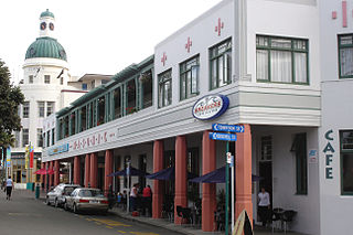
Napier is a city on the eastern coast of the North Island of New Zealand and the seat of the Hawke's Bay region. It is a beachside city with a seaport, known for its sunny climate, esplanade lined with Norfolk pines, and extensive Art Deco architecture. Napier is sometimes referred to as the "Nice of the Pacific", although that is largely outdated and a more common nickname is 'The Art Deco Capital of the world'.

The 1931 Hawke's Bay earthquake, also known as the Napier earthquake, occurred in New Zealand at 10:47 am on 3 February, killing 256, injuring thousands and devastating the Hawke's Bay region. It remains New Zealand's deadliest natural disaster. Centred 15 km north of Napier, it lasted for two and a half minutes and had a magnitude of 7.8 . There were 525 aftershocks recorded in the following two weeks, with 597 being recorded by the end of February. The main shock could be felt in much of New Zealand, with reliable reports coming in from as far south as Timaru, on the east coast of the South Island.

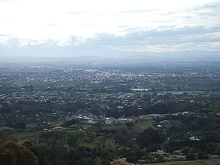
Hastings is an inland city of New Zealand and is one of the two major urban areas in Hawke's Bay, on the east coast of the North Island. The population of Hastings is 51,500, with a further 15,200 people in Havelock North and 2,090 in Clive. Hastings is about 18 kilometres inland of the coastal city of Napier. These two neighbouring cities are often called "The Bay Cities" or "The Twin Cities".
Waipukurau is the largest town in the Central Hawke's Bay District on the east coast of the North Island of New Zealand. It is located on the banks of the Tukituki River, 7 kilometres south of Waipawa and 50 kilometres southwest of Hastings.

Wellington City Council is a territorial authority in New Zealand, governing the city of Wellington, the country's capital city and third-largest city by population, behind Auckland and Christchurch. It consists of the central historic town and certain additional areas within the Wellington metropolitan area, extending as far north as Linden and covering rural areas such as Mākara and Ohariu. The city adjoins Porirua in the north and Hutt City in the north-east. It is one of nine territorial authorities in the Wellington Region.
Hastings District is a Territorial authority district within the Hawke's Bay Region, on the east coast of the North Island of New Zealand. It covers the southern half of the Hawke's Bay coast, excluding Napier City, which is a separate territorial authority. Hastings District Council is headquartered in the city of Hastings, the district's largest town.
Taupō District Council is a territorial authority that administers the Taupō District in the Central North Island of New Zealand. The district stretches from the small town of Mangakino in the northwest to the Tongariro National Park in the south, and east into the Kaingaroa Forest, covering 6,970 km2. It had a population of as of June 2023.
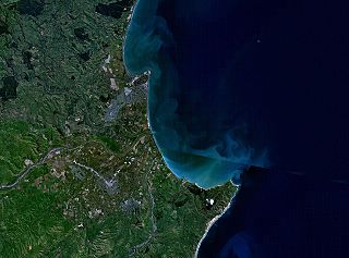
The Napier-Hastings Urban Area was defined by Statistics New Zealand as a main urban area of New Zealand that was based around the twin cities of Napier and Hastings in the Hawke's Bay Region. It was defined under the New Zealand Standard Areas Classification 1992 (NZSAC92), which has since been superseded by the Statistical Standard for Geographic Areas 2018 (SSGA18).

Tasman District Council is the unitary local authority for the Tasman District of New Zealand.

The Christchurch City Council is the local government authority for Christchurch in New Zealand. It is a territorial authority elected to represent the 396,200 people of Christchurch. Since October 2022, the Mayor of Christchurch is Phil Mauger, who succeeded after the retirement of Lianne Dalziel. The council currently consists of 16 councillors elected from sixteen wards, and is presided over by the mayor, who is elected at large. The number of elected members and ward boundaries changed prior to the 2016 election.
Onekawa is a suburb of the city of Napier, in the Hawke's Bay Region of the eastern North Island of New Zealand. Development of the suburb began in the late 1940s, after the land was acquired from then-Harbour Board.

Whangarei District Council is the territorial authority for the Whangarei District of New Zealand. The council consists of the mayor of Whangarei and 13 ward councillors, and is led by the mayor. Vince Cocurullo has been the mayor since 2022.
Hawke's Bay was a parliamentary electorate in the Hawke's Bay Region of New Zealand from 1881 to 1996. In 1986 it was renamed Hawkes Bay.

The Maungakiekie-Tāmaki Local Board is one of the 21 local boards of the Auckland Council. It is the only local board overseen by the council's Maungakiekie-Tāmaki Ward councillor.

New Zealand has a unitary system of government in which the authority of the central government defines sub-national entities. Local government in New Zealand has only the powers conferred upon it by the New Zealand Parliament. Under the Local Government Act 2002, local authorities are responsible for enabling democratic local decision-making and promoting the social, economic, environmental, and cultural well-being of their communities, as well as more specific functions for which they have delegated authority.
Awatoto is a coastal suburb area within the city of Napier, Hawke's Bay, New Zealand. It stretches along the coast south of Te Awa and the central city. The northern part of Awatoto is residential, while the southern part is industrial, including heavy industry.
Marlborough District Council is the unitary local authority for the Marlborough District of New Zealand.

Poraiti is a suburb on the western outskirts of the city of Napier, in the Hawke's Bay region of New Zealand's eastern North Island. For a long time it was a semi-rural locality on low hills, but has now been extended to include a new residential subdivision developed on the plain in the 2000s.

Hastings District Council is the territorial authority for the Hastings District of New Zealand.

