Welcome Bay

Last updated • 3 min readFrom Wikipedia, The Free Encyclopedia

Welcome Bay
Welcome Bay
Country New Zealand
City Tauranga
Electoral wardTe Papa/Welcome Bay
Population
 (2018) [1]
  Total10,284
(Waimapu Estuary)(Tauranga Harbour) Maungatapu
Poike
Pfeil oben.svg
Pfeil links.svgWelcome BayPfeil rechts.svg
Pfeil unten.svg
Welcome Bay
Oropi Ohauiti

Welcome Bay is a suburb of Tauranga, New Zealand. It is located 7 kilometres (4.3 mi) from central Tauranga. Neighbouring suburbs include Hairini and Maungatapu. There are a number of schools in Welcome Bay, including three primary schools. [2]

Contents

The name Welcome Bay has been used for the area as early as 1872 by the Bay of Plenty Times .

Demographics

Historical population
YearPop.±% p.a.
20067,527    
20138,667+2.04%
201810,284+3.48%
Source: [1]

Welcome Bay, comprising the statistical areas of Kaitemako (Tauranga City), Welcome Bay West, Welcome Bay East and Welcome Bay South, had a population of 10,284 at the 2018 New Zealand census, an increase of 1,617 people (18.7%) since the 2013 census, and an increase of 2,757 people (36.6%) since the 2006 census. There were 3,372 households. There were 5,088 males and 5,199 females, giving a sex ratio of 0.98 males per female, with 2,493 people (24.2%) aged under 15 years, 1,833 (17.8%) aged 15 to 29, 4,656 (45.3%) aged 30 to 64, and 1,308 (12.7%) aged 65 or older.

Ethnicities were 80.1% European/Pākehā, 22.5% Māori, 3.3% Pacific peoples, 6.6% Asian, and 2.5% other ethnicities (totals add to more than 100% since people could identify with multiple ethnicities).

The proportion of people born overseas was 21.6%, compared with 27.1% nationally.

Although some people objected to giving their religion, 53.4% had no religion, 32.2% were Christian, 0.8% were Hindu, 0.1% were Muslim, 0.5% were Buddhist and 5.8% had other religions.

Of those at least 15 years old, 1,521 (19.5%) people had a bachelor or higher degree, and 1,203 (15.4%) people had no formal qualifications. The employment status of those at least 15 was that 4,035 (51.8%) people were employed full-time, 1,260 (16.2%) were part-time, and 330 (4.2%) were unemployed. [1]

Individual statistical areas
NamePopulationMedian ageMedian income
Kaitemako (Tauranga City)1,49739 years$32,600
Welcome Bay West2,78132.6 years$32,800
Welcome Bay East2,55637.6 years$28,600
Welcome Bay South3,45035.4 years$37,000
New Zealand37.4 years$31,800


Marae

The local Tahuwhakatiki or Romai Marae and its Rongomainohorangi meeting house are a traditional meeting place for the Ngāti Ranginui hapū of Pirirākau. [3] [4]

In October 2020, the Government committed $500,000 from the Provincial Growth Fund to upgrade the marae, creating 6 jobs. [5]

Climate

Welcome Bay is a sub-tropical climate zone, with warm humid summers and mild winters. Typical summer daytime maximum air temperatures range from 22°C to 26°C, but seldom exceed 30°C. Winter daytime maximum air temperatures range from 12°C to 17°C. Annual sunshine hours average least 2200 hours. Southwest winds prevail for much of the year. Sea breezes often occur on warm summer days. Winter usually has more rain and is the most unsettled time of year. In summer and autumn, storms of tropical origin may bring high winds and heavy rainfall from the east or northeast. [6]

Transport

Public transport in Welcome Bay solely consists of bus services. The suburb is served by one 'Bay Hopper' routes; Route 40(City - 15th Ave - Welcome Bay). [7]

Education

Welcome Bay has two co-educational state primary schools for Year 1 to 6 students: Welcome Bay School, [8] [9] with a roll of 303, [10] and Selwyn Ridge School, [11] [12] with a roll of 450. [13]

Tauranga Waldorf School is a co-educational state-integrated primary school for Year 1 to 8 students, [14] with a roll of 194. [15]

Te Kura Kaupapa Māori o Otepou is a co-educational Māori language immersion school for Year 1 to 8 students, [16] [17] with a roll of 61. [18]

Related Research Articles

Dannevirke Town in Manawatū-Whanganui, New Zealand

Dannevirke, is a rural service town in the Manawatū-Whanganui region of the North Island, New Zealand. It is the major town of the administrative of the Tararua District, the easternmost of the districts of which the Horizons Regional Council has responsibilities.

Tokomaru Bay Town in the North Island of New Zealand

Tokomaru Bay is a small beachside community located on the isolated East Coast of New Zealand's North Island. It is 91 km north of Gisborne, on State Highway 35, and close to Mount Hikurangi. The district was originally known as Toka-a-Namu, which refers to the abundance of sandflies. Over the years the name was altered to Tokomaru Bay.

Ōpōtiki Town in the Bay of Plenty, New Zealand

Ōpōtiki is a small town in the eastern Bay of Plenty in the North Island of New Zealand. It houses the headquarters of the Ōpōtiki District Council and comes under the Bay of Plenty Regional Council.

Richmond, New Zealand Town in Tasman, New Zealand

Richmond is a town and the seat of the Tasman District Council in New Zealand. It lies 13 kilometres (8 mi) south of Nelson in the South Island, close to the southern extremity of Tasman Bay / Te Tai-o-Aorere. The town, first settled by Europeans in 1842, was named in 1854 after the town of Richmond on Thames near London. The town has an estimated population of 18,000 as of June 2021.

Te Puke Town in the Bay of Plenty, New Zealand

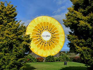
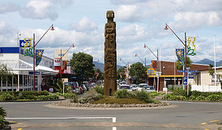
Te Puke is a town located 28 kilometres southeast of Tauranga in the Western Bay of Plenty of New Zealand. It is particularly famous for the cultivation of kiwifruit.

Matakana Island

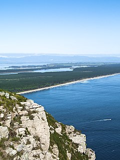
Matakana Island is located in the western Bay of Plenty in New Zealand's North Island. A long, flat barrier island, it is 20 kilometres (12 mi) in length but rarely more than 3 kilometres (1.9 mi) wide. The island has been continuously populated for centuries by Māori tribes that are mostly associated with Ngāi Te Rangi.

Murupara Minor urban area in Bay of Plenty, New Zealand

Murupara is a town located in the Whakatāne District and Bay of Plenty Region of New Zealand's North Island. The town is situated in an isolated part of the region between the Kaingaroa Forest and Te Urewera protected area, on the banks of the Rangitaiki River, 65 kilometres southeast of Rotorua.

Ruatāhuna Place in Bay of Plenty, New Zealand

Ruatāhuna is a small town in the remote country of Te Urewera, in the northeast of New Zealand's North Island. It is 90 kilometres directly west of Gisborne, and 18 kilometres northwest of Lake Waikaremoana. By road, it is 50 kilometres south-east of Murupara, and 110 kilometres north-west of Wairoa. It is on the upper reaches of the Whakatāne River, and surrounded on three sides by the Te Urewera protected area, formerly Te Urewera National Park. The road that runs from Murupara through Ruatāhuna to Aniwaniwa on Lake Waikaremoana, a large part of which is unsealed, used to be designated as part of SH38.

Tolaga Bay Town in Gisborne District, New Zealand

Tolaga Bay is both a bay and small town on the East Coast of New Zealand's North Island located 45 kilometres northeast of Gisborne and 30 kilometres south of Tokomaru Bay.

Papamoa Suburb of Tauranga in New Zealand

Papamoa or Papamoa Beach is a suburb of Tauranga, located about 11 kilometres from the city centre. It is the largest residential suburb in Tauranga. It is bordered to the west by Arataki and Mount Maunganui, the east by the Kaituna River and to the south by State Highway 2.

Ōtaki, New Zealand Place in Wellington Region, New Zealand

Ōtaki is a town in the Kapiti Coast District of the North Island of New Zealand, situated half way between the capital city Wellington, 70 km (43 mi) to the southwest, and Palmerston North, 70 km (43 mi) to the northeast.

Seatoun Suburb of Wellington City in New Zealand

Seatoun, an eastern suburb of Wellington, the capital city of New Zealand, lies on the east coast of the Miramar Peninsula, close to the entrance to Wellington Harbour, some seven kilometres southeast of the CBD. The suburb sits on an exposed promontory close to Barrett Reef, a dangerous area of rocky shallows upon which many ships have foundered, most notably the inter-island ferry TEV Wahine in 1968.

Onekawa is a suburb of the city of Napier, in the Hawke's Bay Region of the eastern North Island of New Zealand.

Wharekahika Town in Gisborne District, New Zealand

Wharekahika or Hicks Bay is a bay and coastal area in the Gisborne District of the North Island of New Zealand. It is situated 150 km east of Opotiki and 186 km north of Gisborne city, along State Highway 35 between Potaka and Te Araroa.

Bethlehem is a suburb of Tauranga in New Zealand's North Island. Originally a small independent town, it has now been absorbed by Tauranga and comprises a number of subdivisions including Bethlehem Heights, Sterling Gate, La Cumbre, Saint Andrews, and Mayfield.

Waioeka is a rural community in the Ōpōtiki District and Bay of Plenty Region of New Zealand's North Island.

Matapihi is a suburb and peninsula of Tauranga in the Bay of Plenty region of New Zealand's North Island, surrounded on most sides by the Tauranga Harbour.

Rotoiti is a settlement on the shore of Lake Rotoiti, in Rotorua Lakes within the Bay of Plenty Region of New Zealand's North Island.

Mangakakahi is a suburb of Rotorua in the Bay of Plenty Region of New Zealand's North Island.

Castlecliff is a suburb of Whanganui, in the Whanganui District and Manawatū-Whanganui region of New Zealand's North Island.

References

  1. 1 2 3 "Statistical area 1 dataset for 2018 Census". Statistics New Zealand. March 2020. Kaitemako (Tauranga City) (196300), Welcome Bay West (196600), Welcome Bay East (196700) and Welcome Bay South (196900). 2018 Census place summary: Kaitemako (Tauranga City) 2018 Census place summary: Welcome Bay West 2018 Census place summary: Welcome Bay East 2018 Census place summary: Welcome Bay South
  2. "Welcome Bay, Tauranga". www.qv.co.nz. Retrieved 10 January 2017.
  3. "Te Kāhui Māngai directory". tkm.govt.nz. Te Puni Kōkiri.
  4. "Māori Maps". maorimaps.com. Te Potiki National Trust.
  5. "Marae Announcements" (Excel). growregions.govt.nz. Provincial Growth Fund. 9 October 2020.
  6. "Climate". niwa.co.nz. NIWA. October 2017.
  7. "City 15th Ave Welcome Bay". baybus.co.nz. Bay Bus.
  8. "Welcome Bay School Official School Website". welcomebay.school.nz.
  9. "Welcome Bay School Ministry of Education School Profile". educationcounts.govt.nz. Ministry of Education.
  10. "Welcome Bay School Education Review Office Report". ero.govt.nz. Education Review Office.
  11. "Selwyn Ridge School Official School Website". selwynridge.school.nz.
  12. "Selwyn Ridge School Ministry of Education School Profile". educationcounts.govt.nz. Ministry of Education.
  13. "Selwyn Ridge School Education Review Office Report". ero.govt.nz. Education Review Office.
  14. "Rudolf Steiner School Ministry of Education School Profile". educationcounts.govt.nz. Ministry of Education.
  15. "Rudolf Steiner School Education Review Office Report". ero.govt.nz. Education Review Office.
  16. "Te Kura Kaupapa Māori o Otepou Official School Website". otepou.school.nz.
  17. "Te Kura Kaupapa Māori o Otepou Ministry of Education School Profile". educationcounts.govt.nz. Ministry of Education.
  18. "Te Kura Kaupapa Māori o Otepou Education Review Office Report". ero.govt.nz. Education Review Office.

Coordinates: 37°43′47″S176°11′15″E / 37.72972°S 176.18750°E / -37.72972; 176.18750