
Western Bay of Plenty District is a territorial authority within the Bay of Plenty Region of New Zealand. The district envelops Tauranga City by land, and includes Matakana Island, at the entrance to Tauranga Harbour.
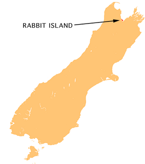
Moturoa / Rabbit Island is a small island located in the southernmost part of the Tasman Bay, in the northern coast of New Zealand's South Island. It lies across the southernmost part of Tasman Bay, at the top of New Zealand's South Island. The long narrow island runs east-west for 8 kilometres (5 mi), and covers 15 km2 (5.8 sq mi).

Motiti Island is located off the Bay of Plenty coast of New Zealand's North Island. It is 21 kilometres (13 mi) north-east of Tauranga and 9.4 kilometres (5.8 mi) north-east of Papamoa. There were 18 homes occupied by 27 people on the island in the 2006 census.

The Diocese of Waiapu is one of the thirteen dioceses and hui amorangi of the Anglican Church in Aotearoa, New Zealand and Polynesia. The Diocese covers the area around the East Coast of the North Island of New Zealand, including Tauranga, Taupo, Gisborne, Hastings and Napier. It is named for the Waiapu River.

The Waitahanui River is a river in the North Island of New Zealand.

Omokoroa is a small urban area in the Western Bay of Plenty District of New Zealand. The suburb is considered part of Greater Tauranga, and is within the Bay of Plenty electorate. Omokoroa began as a small rural holiday village, but is expanding to be a commuter town, with a 25-minute drive to Tauranga City.

Pikowai is a rural community located near the beach on the shoreline of the Eastern Bay of Plenty in the North Island of New Zealand. Pikowai is located 34 km southeast of Te Puke and 10 kilometres northwest of Matata. It is said to be a place where the Mataatua Canoe made landfall on its journey along the coast from Tauranga. Known for its fishing, the beach itself is well used for surf casting.

Ngāti Pūkenga is a Māori iwi centred in Tauranga in the Bay of Plenty region of New Zealand. Its rohe extends to Mayor Island / Tuhua and Waihi in the north, to the Kaimai Range in the west, south of Te Puke and to Maketu in the east, and it has tribal holdings in Whangarei, Hauraki and Maketu.
The Wairoa River runs north into Tauranga Harbour at the western end of the Bay of Plenty in New Zealand's North Island.
Bethlehem is a suburb of Tauranga in New Zealand's North Island. Originally a small independent town, it has now been absorbed by Tauranga and comprises a number of subdivisions including Bethlehem Heights, Sterling Gate, La Cumbre, Saint Andrews, and Mayfield.
Toi Ohomai Institute of Technology is a New Zealand tertiary education institute with campuses in Rotorua, Tauranga, and other towns in the Bay of Plenty region. It was formed in May 2016 after the amalgamation of the Bay of Plenty Polytechnic and Waiariki Institute of Technology. Toi Ohomai is the largest tertiary provider in the Bay of Plenty, and the third largest institute of technology in New Zealand.
The Tauranga Harbour Bridge refers to two bridges that carry Te Awanui Drive over the Tauranga Harbour. Te Awanui Drive is part of an expressway that connects Tauranga to Mount Maunganui. On the Tauranga side, Te Awanui Drive connects to Takitimu Drive, which crosses the Chapel Street Viaduct before running along the edge of the Waikareao Estuary. On the Mount Maunganui side, Te Awanui Drive connects to Hewletts Road, which runs through an industrial area towards Maunganui Road.

Tauranga Harbour is the natural tidal harbour that surrounds Tauranga CBD and the Mount Maunganui area of Tauranga, New Zealand, and which flows into the Pacific Ocean at Mount Maunganui and Bowentown. The harbour is effectively two flooded river systems separated from the Pacific Ocean by Matakana Island.
The Omanawa River is a river of the Bay of Plenty Region of New Zealand's North Island.
The Opuiaki River is a river of the Bay of Plenty Region of New Zealand's North Island. It flows north from the Mamaku Plateau into Lake McLaren, to reach the Wairoa River 15 kilometres (9 mi) southwest of Tauranga. The river contributes to the Kaimai Hydro power scheme built in the 1980s. A dam was built up hill from where the Ngatuhoa Lodge is now located. From the dam a tunnel was dug,which channels the water into the Ngatuhoa Stream, where it enters just above another dam built there. Provisions are made to maintain some flow in both streams. Digging the tunnel was a challenging operation due to the geology of the area, formed by volcanic activity from various volcanoes, with clay and other sediment in between. Artesian waters also flow between the layers of rock and contribute to the flow of the streams in the area.

The Classic Flyers Museum is an aviation museum located at the Tauranga Airport, Mount Maunganui, New Zealand, owned by a registered New Zealand charitable trust, the Bay of Plenty Classic Aircraft Trust.

State Highway 29 (SH 29) is a New Zealand state highway that travels over the Kaimai Ranges linking the Bay of Plenty and Waikato regions. For most of its length, SH 29 is a two-lane single carriageway with occasional passing lanes and slow vehicle bays. 5 km of it near its eastern terminus is part of the Takitimu Drive Toll Road.

Pyes Pa is a suburb of Tauranga, New Zealand. As of the 2013 Census, Pyes Pa had a population of about 6,036 people, making it the most populated suburb in Tauranga
Greerton is a major suburb of the city of Tauranga in the Bay of Plenty region of New Zealand, and in the 2013 census it had a total population of 4,173.
Tauranga South is a suburb of Tauranga, New Zealand, next to the city center. Nearby areas include Fraser Cove, Judea and Tauranga Central.


