Tauranga Central

Last updated

Tauranga Central
Tauranga Post Office.jpg
Old Tauranga Post Office
Tauranga Central
Coordinates: 37°41′04″S176°10′12″E / 37.684363°S 176.170074°E / -37.684363; 176.170074
CountryNew Zealand
City Tauranga
Local authority Tauranga City Council
Electoral wardTe Papa General Ward
Area
[1]
  Land346 ha (855 acres)
Population
 (June 2023) [2]
  Total2,920
Otūmoetai (Tauranga Harbour) Mount Maunganui
(Waikareao Estuary)
Pfeil oben.svg
Pfeil links.svgTauranga CentralPfeil rechts.svg
Pfeil unten.svg
(Tauranga Harbour)
Tauranga South

Tauranga Central is a suburb and the central business district of Tauranga, in the Bay of Plenty Region of New Zealand's North Island.

Contents

Demographics

Tauranga Central covers 3.46 km2 (1.34 sq mi) [1] and had an estimated population of 2,920 as of June 2023, [2] with a population density of 844 people per km2.

Historical population
YearPop.±% p.a.
20062,289    
20132,322+0.20%
20182,625+2.48%
Source: [3]

Tauranga Central had a population of 2,625 at the 2018 New Zealand census, an increase of 303 people (13.0%) since the 2013 census, and an increase of 336 people (14.7%) since the 2006 census. There were 1,092 households, comprising 1,266 males and 1,362 females, giving a sex ratio of 0.93 males per female. The median age was 52.1 years (compared with 37.4 years nationally), with 243 people (9.3%) aged under 15 years, 468 (17.8%) aged 15 to 29, 1,083 (41.3%) aged 30 to 64, and 828 (31.5%) aged 65 or older.

Ethnicities were 77.4% European/Pākehā, 10.6% Māori, 2.4% Pacific peoples, 15.0% Asian, and 2.4% other ethnicities. People may identify with more than one ethnicity.

The percentage of people born overseas was 31.5, compared with 27.1% nationally.

Although some people chose not to answer the census's question about religious affiliation, 40.7% had no religion, 43.7% were Christian, 0.8% had Māori religious beliefs, 2.4% were Hindu, 1.3% were Muslim, 1.4% were Buddhist and 3.7% had other religions.

Of those at least 15 years old, 507 (21.3%) people had a bachelor's or higher degree, and 381 (16.0%) people had no formal qualifications. The median income was $29,300, compared with $31,800 nationally. 339 people (14.2%) earned over $70,000 compared to 17.2% nationally. The employment status of those at least 15 was that 1,017 (42.7%) people were employed full-time, 327 (13.7%) were part-time, and 66 (2.8%) were unemployed. [3]

Economy

Bay Central Shopping Centre is located in Tauranga Central. It consists of 30 stores, including Briscoes and Rebel Sport. [4]

Notable buildings

The Elms Mission House The Elms Mission House.jpg
The Elms Mission House

Education

Tauranga Primary is a co-educational state primary school for Year 1 to 8 students, [16] [17] with a roll of 423 as of February 2024. [18]

Related Research Articles

<span class="mw-page-title-main">Devonport, New Zealand</span> Suburb in Auckland, New Zealand

Devonport is a harbourside suburb of Auckland, New Zealand. It is located on the North Shore, at the southern end of the Devonport Peninsula that runs southeast from near Lake Pupuke in Takapuna, forming the northern side of the Waitematā Harbour. East of Devonport lies North Head, the northern promontory guarding the mouth of the harbour.

<span class="mw-page-title-main">Mount Maunganui</span> Suburb of Tauranga, New Zealand

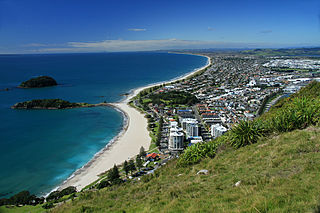
Mount Maunganui is a major residential, commercial and industrial suburb of Tauranga located on a peninsula to the north-east of Tauranga's city centre. It was an independent town from Tauranga until the completion of the Tauranga Harbour Bridge in 1988, which connects Mount Maunganui to Tauranga's central business district.

<span class="mw-page-title-main">Fendalton</span> Suburb of Christchurch, New Zealand

Fendalton is a suburb of Christchurch, in the South Island of New Zealand.

<span class="mw-page-title-main">Cashmere, New Zealand</span> Suburb of Christchurch, New Zealand

Cashmere is a suburb which rises above the southern end of the city of Christchurch in New Zealand's South Island, on the north side of the Port Hills. It covers an area of 4.71 km2 (1.82 sq mi) and has a population of 6,453 as at 2018.

<span class="mw-page-title-main">Sydenham, New Zealand</span> Suburb of Christchurch, New Zealand

Sydenham is an inner suburb of Christchurch, New Zealand, two kilometres south of the city centre, on and around the city's main street, Colombo Street. It is a residential, retail and light industrial suburb.

<span class="mw-page-title-main">Balmoral, New Zealand</span> Suburb in Auckland, New Zealand

Balmoral is a suburb of Auckland, New Zealand that is bordered by Mount Eden, Epsom, Mount Roskill and Sandringham and is located approximately 5 km from the centre of Auckland. It was named around the turn of the 20th century and derives its name from Balmoral Castle, the Scottish country residence of the Royal family. Much of the housing in the area is from the 1920s and 1930s, often in the Californian Bungalow style. Balmoral was part of Mount Eden Borough Council which became a part of Auckland City in 1989. In November 2010, the area was included into the Albert-Eden-Roskill ward of the new Auckland Council.

<span class="mw-page-title-main">Merivale, Christchurch</span> Suburb of Christchurch, New Zealand

Merivale is a suburb of Christchurch, New Zealand, north of the city centre. Like all suburbs in Christchurch, it has no defined boundaries and is a general area, but for the purposes of statistical analysis only, Statistics New Zealand defines it as being Heaton Street to the north, Papanui Road to the east, Harper and Bealey Avenues to the south and Rossall Street to the west, although Real Estate advertising often will claim residences outside this area, especially St Albans to the east of Papanui Road, as being Merivale due to the perceived desirability of the area. The area directly west of Rossall Street, which is called Holmwood by Statistics New Zealand, is sometimes considered part of Merivale.

<span class="mw-page-title-main">Moana, New Zealand</span> Town in the South Island of New Zealand

Moana is a small town in the West Coast Region of the South Island of New Zealand. It is situated on the northern shore of Lake Brunner, and is beside the outflow of the lake into the Arnold River. There is a pedestrian suspension bridge crossing the Arnold from the town to access the lake shore across the river, with some short easy bush walks on each side.

<span class="mw-page-title-main">Colombo Street</span> Main road in Christchurch, New Zealand

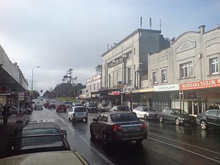
Colombo Street is a main road of the city of Christchurch, New Zealand. It runs south-north through the centre of Christchurch with a break at Cathedral Square. As with many other central Christchurch streets, it is named for a colonial Anglican bishopric, Colombo, Sri Lanka in what at the time was known as Ceylon. Parts of the street which run through Sydenham were known as Addison Street during the 1880s, and some parts were known as Colombo Road.

<span class="mw-page-title-main">Governors Bay</span> Settlement in Christchurch, New Zealand

Governors Bay is a small town in Canterbury, New Zealand.

<span class="mw-page-title-main">Symonds Street</span> Street in Auckland, New Zealand

Symonds Street is a street in Auckland, New Zealand's most populous city. The road runs southwest and uphill from the top of Anzac Avenue, through the City Campus of University of Auckland, over the Northwestern Motorway and Auckland Southern Motorway and to the start of New North Road and Mount Eden Road.

<span class="mw-page-title-main">Appleby, New Zealand</span> Locality in Tasman District, New Zealand

Appleby is a locality in the Tasman district in the South Island of New Zealand. It is located around the Waimea River near the Tasman Bay / Te Tai-o-Aorere. It was first settled in the early 1840s. State Highway 60 passes through the settlement.

<span class="mw-page-title-main">East Taieri</span> Settlement in New Zealand

East Taieri is a small township, located between Mosgiel and Allanton in New Zealand's Otago region. It lies on State Highway 1 en route between the city of Dunedin and its airport at Momona. It lies close to the southeastern edge of the Taieri Plain, hence its name.

<span class="mw-page-title-main">Moawhango</span> Rural community in Manawatū-Whanganui, New Zealand

Moawhango is a rural community in the northern part of Rangitikei District of the Manawatū-Whanganui region of New Zealand's North Island. It is situated 19 km north of Taihape and 91 km northeast of Marton. Nearby Moawhango are located Moawhango River and Lake Moawhango.

<span class="mw-page-title-main">Hobson Street, Auckland</span>

Hobson Street is the major street in Auckland, New Zealand. It lies on the western side of Queen Street. It is a commercial and high-rise residential street, and provides access to the Auckland Northern Motorway going south, and the Northwest Motorway going west. For most of its length it is one-way. One block to the west is Nelson Street, which is one-way in the other direction and provides access to the central city for traffic exiting from the motorways. One block to the east is Albert Street, part of Mayoral Drive, and Vincent Street. The area encompassed by these streets is called Hobson Ridge by Statistics New Zealand.

<span class="mw-page-title-main">Quay Street, Auckland</span> Street in Auckland, New Zealand

Quay Street is the northernmost street in the Auckland CBD, New Zealand. The Auckland Ferry Terminal, which has ferries running to Devonport, Waiheke Island, and other places in Waitematā Harbour; the Hilton Auckland hotel; and Ports of Auckland are on the north side of the street. The Britomart Transport Centre, Queen Elizabeth Square and Grand Mercure Auckland hotel are on the south side.

<span class="mw-page-title-main">Shortland Street, Auckland</span> Street in Auckland, New Zealand

Shortland Street was the initial commercial street of Auckland and remains a key financial and legal centre for Auckland city. It runs east from Queen Street up to Princes Street, providing a connection from the business district to the Auckland High Court and University of Auckland.

<span class="mw-page-title-main">Anzac Avenue, Auckland</span> Urban road of Auckland, New Zealand

Anzac Avenue is a street in Auckland, New Zealand's most populous city. It was constructed between 1914 and 1919 to link Beach Road to Symonds Street, and was named as a memorial to the troops who died in the Gallipoli campaign.

<span class="mw-page-title-main">Hamilton Lake (suburb)</span> Suburb of Hamilton, New Zealand

Hamilton Lake is a residential suburb of Hamilton, surrounding Lake Rotoroa and the Hamilton Lake Domain. Most of the housing in the suburb was built in the 1970s. The roads close to the lake are considered to be amongst Hamilton's premium streets.

References

  1. 1 2 "ArcGIS Web Application". statsnz.maps.arcgis.com. Retrieved 15 January 2024.
  2. 1 2 "Population estimate tables - NZ.Stat". Statistics New Zealand . Retrieved 25 October 2023.
  3. 1 2 "Statistical area 1 dataset for 2018 Census". Statistics New Zealand. March 2020. Tauranga Central (193800). 2018 Census place summary: Tauranga Central
  4. "Bay Central Shopping Centre - Stores". baycentral.co.nz. Stride Property.
  5. "The Elms Mission House and Library". New Zealand Heritage List/Rārangi Kōrero. Heritage New Zealand . Retrieved 6 December 2020.
  6. "Tauranga Bond Store". New Zealand Heritage List/Rārangi Kōrero. Heritage New Zealand . Retrieved 6 December 2020.
  7. "War Memorial Gates". New Zealand Heritage List/Rārangi Kōrero. Heritage New Zealand . Retrieved 6 December 2020.
  8. "Post Office/Government Building (Former)". New Zealand Heritage List/Rārangi Kōrero. Heritage New Zealand . Retrieved 6 December 2020.
  9. "Hotel St Amand". New Zealand Heritage List/Rārangi Kōrero. Heritage New Zealand . Retrieved 6 December 2020.
  10. "Hotel St Amand, Tauranga (advice)". Heritage Equip. Retrieved 6 December 2020.
  11. "Brain-Watkins House". New Zealand Heritage List/Rārangi Kōrero. Heritage New Zealand . Retrieved 6 December 2020.
  12. "Native School and Hostel". New Zealand Heritage List/Rārangi Kōrero. Heritage New Zealand . Retrieved 6 December 2020.
  13. "Taiparoro". New Zealand Heritage List/Rārangi Kōrero. Heritage New Zealand . Retrieved 6 December 2020.
  14. "House & Adjoining Shop [Relocated]". New Zealand Heritage List/Rārangi Kōrero. Heritage New Zealand . Retrieved 6 December 2020.
  15. "Hotel on Devonport- Emporis". Archived from the original on 26 January 2021.{{cite web}}: CS1 maint: unfit URL (link)
  16. "Tauranga Primary Official School Website". tauranga.school.nz.
  17. "Tauranga Primary Ministry of Education School Profile". educationcounts.govt.nz. Ministry of Education.
  18. "Tauranga Primary Education Review Office Report". ero.govt.nz. Education Review Office.