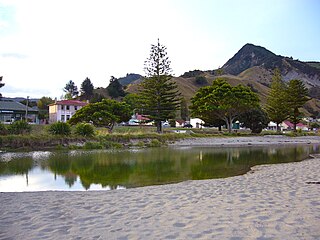
Tokomaru Bay is a small beachside community on the remote East Coast of New Zealand's North Island. It is 91 km north of Gisborne, on State Highway 35, and close to Mount Hikurangi. The district was originally known as Toka-a-Namu, which refers to the abundance of sandflies. Over the years the name was altered to Tokomaru Bay.

Tikokino is a town in the Central Hawke's Bay District on the east coast of the North Island of New Zealand. It is located 20 kilometres (12 mi) northwest of Waipawa and 55 kilometres (34 mi) southwest of Hastings. The township is located on State Highway 50.

Katikati is a town in New Zealand located on the Uretara Stream near a tidal inlet towards the northern end of Tauranga Harbour, 28 kilometres south of Waihi and 40 kilometres northwest of Tauranga. State Highway 2 passes through the town; a bypass scheduled to have begun construction in 2008 is on hold.

Matakana Island is located in the western Bay of Plenty in New Zealand's North Island. A long, flat barrier island, it is 20 kilometres (12 mi) in length but rarely more than 3 kilometres (1.9 mi) wide. The island has been continuously populated for centuries by Māori tribes that are mostly associated with Ngāi Te Rangi.

Māhia Peninsula is located on the east coast of New Zealand's North Island, in the Hawke's Bay region, between the towns of Wairoa and Gisborne.

Tolaga Bay is both a bay and small town on the East Coast of New Zealand's North Island located 45 kilometres northeast of Gisborne and 30 kilometres south of Tokomaru Bay.

Ngāi Te Rangi or Ngāiterangi is a Māori iwi, based in Tauranga, New Zealand. Its rohe extends to Mayor Island / Tuhua and Bowentown in the north, to the Kaimai Range in the west, south of Te Puke and to Maketu in the east.

Nūhaka is a small settlement in the northern Hawke's Bay Region of New Zealand's eastern North Island, lying on State Highway 2 between Wairoa and Gisborne. The road to Mahia turns off the highway at Nūhaka.
Tautoro is a locality about 8 km south-southeast of Kaikohe in Northland, New Zealand. Further to the south is the Awarua rural community.

Whareama is a rural area in the Wellington Region of New Zealand's North Island. The Whareama River flows through the area.

Ohinemutu or Ōhinemutu is a suburb in Rotorua, New Zealand. It includes a living Māori village and the original settlement of Rotorua.
Waimana is a rural valley in the Whakatāne District and Bay of Plenty Region of New Zealand's North Island. It is located in the northern Te Urewera. Waimana River, originally known as Tauranga River, runs through the valley, joining the Ohinemataroa River one kilometre south-west of Tāneatua.

Welcome Bay is a suburb of Tauranga, New Zealand. It is located 7 kilometres (4.3 mi) from central Tauranga. Neighbouring suburbs include Hairini and Maungatapu. There are a number of schools in Welcome Bay, including three primary schools.
Hairini is a suburb of Tauranga in the Bay of Plenty region of New Zealand's North Island.

Maungatapu is a suburb and peninsula of Tauranga in the Bay of Plenty region of New Zealand's North Island. It is north-east of Hairini and south-east of Matapihi.
Judea is a suburb of Tauranga in the Bay of Plenty region of New Zealand's North Island. It is located on State Highway 2, east of Bethlehem.

Pirinoa is a rural community east of Lake Wairarapa, in the South Wairarapa District and Wellington Region of New Zealand's North Island. It includes the rural settlement of Pirinoa, and the coastal settlement of Whāngaimoana.
Rangiuru is a rural community in the Bay of Plenty of New Zealand's North Island.

Rotoiti is a settlement on the shore of Lake Rotoiti, in Rotorua Lakes within the Bay of Plenty Region of New Zealand's North Island.
Ngapuna is a suburb in eastern Rotorua in the Bay of Plenty Region of New Zealand's North Island.


