Stations
Addington
Until the 1970s, Addington was a major facility for the receiving and sale of livestock, with significant stock yards, races and loading platforms beside the track. It handled livestock traffic from as far afield as Marlborough, South Canterbury and the West Coast, with the proceeds of the sales destined for locations all over the South Island. Given the limited size of the lorry transport available at the time, it is understandable how the railways could compete with road transport for this type of traffic, even for relatively short distances.
One particularly sought-after source of livestock for Addington was the sheep of the Molesworth cattle and sheep station in Marlborough. From 1957 until about 1970, this livestock was driven to the railhead at Culverden (on the Waiau Branch line) then transported in several trains to Addington. In the last years of this traffic, there were in excess of 1,000 head to move, requiring a substantial portion of the cattle wagon fleet in the South Island.
When the workshops closed, it was decided to locate the new Christchurch railway station on the site for long distance trains (opened on 5 April 1993), see Christchurch railway station, New Zealand § Third station.
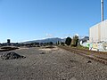
Today, the passenger facilities are gone, but the site still retains a signal box, several loops and railsheds for the storage of rolling stock. The land formerly occupied by the saleyards is currently a vacant lot.
 The former saleyards building.
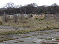 Saleyards land and rear of the saleyards building.
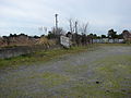 Loading races for stock trucks.


Belfast
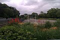
 ite of the former Belfast railways station, north of Christchurch in New Zealand.


 Belfast railway station in Christchurch


Bryndwr
This station served passenger trains for residents of the suburbs of Bryndwr and Elmwood. Nothing of the station remains.
 Looking north towards Papanui at Wairakei Road.
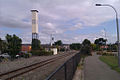 looking south towards Riccarton.


Burnham
 Map of Burnham

Christchurch
The current Christchurch station at Troup Drive is the third railway Christchurch station. The two earlier stations, at Madras Street and Moorhouse Avenue, were a short distance away to the east on the Main South Line, closer to the city centre.
 Christchurch platform and baggage conveyor, looking at the line passing beneath the new Blenheim Road overbridge.
 Christchurch platform and building, looking in the direction of Addington junction.
 Main platform and former station yard area at Moorhouse Avenue.
 Christchurch railway station building, Moorhouse Avenue.


Heathcote
Originally known as The Valley, this station was sited about 240 metres from the mouth of the Lyttelton rail tunnel. It was equipped with a signal box, freight sidings for nearby industrial customers as well as passenger facilities and a platform, which is the only remaining feature. Public access is from Station Road, at the intersection with Flavell Street, Marsden Street and Rollin Street.
The signal box, constructed in 1870, was to have been moved to the Ferrymead Heritage Park for use in the rail operations there after many years of disuse until it was destroyed on-site by fire in September 1996, shortly before its relocation.
 Looking along the Heathcote station platform in the direction of the Lyttelton rail tunnel.
 Looking along the Heathcote station platform in the direction of Ferrymead.
 Overview of the former Heathcote station site showing the only remnant of the station still visible, its platform. The Main South Line disappears into the Lyttelton rail tunnel beneath where this picture was taken from.
 Public access to the Heathcote station platform is gained through this gate from Station Road.
 Looking along the Heathcote station platform in the direction of the Lyttelton rail tunnel.


Hornby
 Map of Hornby
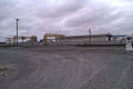 The back of loading bank can be seen in front of the station platform.
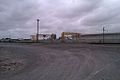 The back of loading bank can be seen in front of the station platform.
 Looking at the main platform from up close.
 Looking at the platforms together
 Main platform from the side.


Islington
 Map of Islington

Kaiapoi
The Main North Line railway runs through Kaiapoi, and the town once served as the junction for the Eyreton Branch, which provided rail access to communities west of Kaiapoi such as West Eyreton (though it ran to the north of Eyreton itself). This branch line opened in 1875 and closed fully by April 1965.
 Old Kaiapoi Station after relocation.
 Site of relocation showing damage after the September 2010 Canterbury earthquake.


Kainga
The station at Kainga was a small rural station to serve the settlement of Kainga. Nothing of the station remains. The Main North Line through Kainga was opened on 1 September 1958 as a deviation when the Waimakariri River Bridge at Stewarts Gully was replaced with a new structure 1.6 km upstream.
 Map of Kainga
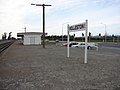
 Looking North from station site.


Ladbrooks
 Map of Ladbrooks

Lincoln
 Map of Lincoln

Linwood
One of the "younger" stations on the line, Linwood was not built by the provincial council. Nothing remains of the station today, though it continued to serve in a rail capacity as the location of a locomotive depot until the depot was damaged beyond repair in the 2011 Christchurch earthquake and subsequently demolished, with the services it provided relocated to Middleton.
 Site of the Linwood railway station.
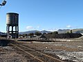 Water tower and turntable at the Linwood station site.
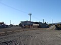 Linwood Locomotive Depot.


Little River
The Little River station has been well preserved by the local community, who have converted into a centre that sells local craft and historical items. The platform and goods shed are still in good repair, and some metres of trackage have been installed so that a number of preserved freight wagons can be displayed.
 The Little River railway station on Banks Peninsula, these days used as a tourist information, craft shop and public toilets.
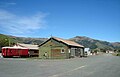 View from the northern side of the surprisingly large former yard at Little River. The main road from Christchurch to Akaroa runs behind the station, which is visible above the guard's van.
 A wagon parked at the Little River Railway Station.
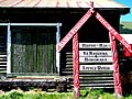 Welcome sign leaning against the goods shed of the Little River Railway Station.
 A Guard's Van at the Little River Railway Station.
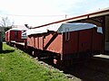 La Class open wagon, two N Class flat wagons, and a guard's van sit in the yard at Little River on a small section of track.
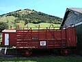 Hc Class cattle wagon HC1018 and ganger's hut (on loading bank) at Little River. A notable omission are the running boards that should be on top of the roof.
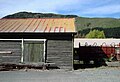 Goods shed, loading bank, and Hc Class cattle wagon.


Lyttelton
Lyttelton railway station is the northern terminus of the Main South Line, a main trunk railway line from Lyttelton to Invercargill in the South Island of New Zealand. There have been three stations built at Lyttelton, with the most recent of these still being used for railway purposes.
 Map of Lyttelton
 Lyttelton railway station.
 Lyttelton railway station yard. Features of interest include the Oxford Street overbridge (middle), Lyttelton station building (right, in front of the bridge), shore-end of wharves 2 and 3 (left, opposite the end of the bridge), Lyttelton rail tunnel portal (obscured, centre background), and Lyttelton road tunnel portal (centre-right background). Also shown are two of the ports main sources of traffic: timber and motor vehicles.
 Lyttelton railway station from above.
 Lyttelton railway station as seen from Norwich Quay.


Middleton
 Map of Middleton

The Middleton Marshalling Yard in Christchurch on the Christchurch-Ashburton Line had a hump for shunting, and was opened on 5 December 1927. It closed in September 1930, then reopened in November 1946. Later it closed on 13 October 1986 for local loading and deliveries and fully closed on 22 October 1998. [3]
Opawa
This station served passenger trains for residents of the suburb of Opawa. Nothing of the station remains.
 Map of Opawa
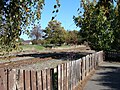 Opawa railway station site, from the Richardson Terrace - Judge Street walkway.
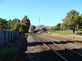 Opawa railway station site, looking south towards Woolston.
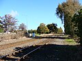 Opawa railway station site, looking north towards Linwood.
 Heathcote River rail bridge, just south of the Opawa railway station site.


Papanui
The Papanui Railway Station closed in June 1991. It is located in Restell Street, Papanui, Christchurch, and is registered by the New Zealand Historic Places Trust as a Category II heritage building with registration number. [4]
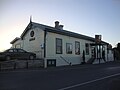 Papanui Railway Station from Restell Street.
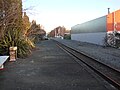 View of the railway tracks south at Harewood Road.
 View of the platform.
 Sign detail.


Rangiora
 View of the platform
 Rangiora Railway Station from Blackett Street
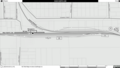 Map of Rangiora Station


Riccarton
The Riccarton railway station was located on the Main North Line, accessible from the south via Matai Street. The station building was to the west of the line. [5]
Riccarton station was last serviced by a single weekday return service between Christchurch and Rangiora in 1976. These services were popular with commuters working in the eastern parts of the city, and also with railway staff based at the Addington Railway Workshops.
In 1959, there were still two daily return services. Riccarton station at the time had a small but busy freight yard, handling coal consignments for local merchants, timber from the West Coast, and wheat and flour traffic for the mill sited on land that now forms the grounds of Christchurch Girls' High School. [5]
For many years, a special train ran through Riccarton station to the October meeting of the Kaikoura Trotting Club. It conveyed patrons, horses, trainers, sulkies and jockeys. The popularity of this train diminished as horse floats were used to take horses and trainers to the meetings, and patrons opting to travel using private cars. The fact that the meetings were held midweek also limited the appeal.
In its heyday, in addition to the platform, station building and main line, the station also had a couple of loops and a curved siding from the north end of the yard that provided access to the flour mill. [5] In late 1905, a spur line was built that left the Main North Line in this location heading through North Hagley Park to service the International Exhibition. The spur was used for freight traffic only and was removed in 1908. [6] [7]
Today, no obvious signs of the station remain. The yard is now a bus and car park, and a cycle/walk way runs along the western side of the line connecting Fendalton Road with Kereru Lane, which runs the length of the former yard.
 Former station site
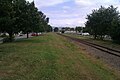 View of the railway track south


Rolleston
The small south Canterbury town of Rolleston was first served by a railway station built by the Canterbury Provincial Railways on their broad gauge line from Christchurch, which was then known as the Canterbury Great Southern Railway. Since then, the station has been patronised by a variety of services, most recently by the long-distance TranzAlpine passenger train. [8]
The station is located on State Highway 1, at the intersection of Main South Road and Rolleston Drive. The current station building opened on March 17 1969 [9]
 Rolleston railway station, looking north towards Templeton.
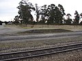 Loading bank.
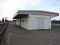 Station building.
 Rolleston station yard, looking south in the direction of the Midland Line junction.


Sockburn
 Map of Sockburn

Stewarts Gully
This station served the settlement of Stewarts Gully on the south bank of the Waimakariri River, just south of Kaiapoi. The dates of operation of the station are not known at the time of writing, but the Main North Line in the area opened on 29 April 1872, and closed on 31 August 1958 when the Waimakariri River Bridge was replaced with a new structure and associated trackage 1.6 km upstream.
 Map of Stewarts Gully

Templeton
 Map of Templeton

Weedons
 Map of Weedons

Woolston
Formerly known as Hillsborough after another nearby suburb, this station continues to serve as a freight hub for several adjacent industrial customers. The platform and loading bank remain, though the station building has been demolished.
 View along the Woolston Railway Station platform.
 Woolston Railway Station: wagon sidings, foreground; container storage yard, background; loading bank, right.
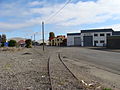 Disused private siding across Maunsell Street from the Woolston Railway Station yard.
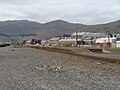 View from the side of the Woolston Railway Station platform.


