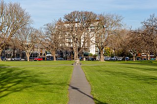
Hagley Park is the largest urban open space in Christchurch, New Zealand, and was created in 1855 by the Provincial Government. According to the government's decree at that time, Hagley Park is "reserved forever as a public park, and shall be open for the recreation and enjoyment of the public." Hagley Park is characterised by its trees and broad open spaces. Hagley Park was named after Hagley Park, the country estate of Lord Lyttelton, who became chairman of the Canterbury Association in March 1850.

Papanui is a major suburb of Christchurch, New Zealand. It is situated five kilometres to the northwest of the city centre. Papanui is a middle socio-economic area with a population of 3,645 consisting predominantly of Pākehā 86.9%, Asian 7.6%, Māori 5.3%, Pacific peoples 3.1%, Middle Eastern/Latin American/African 0.7%. The suburb is located at the junction of three busy thoroughfares; Papanui Road leading to the city, the Main North Road that leads to North Canterbury and Harewood Road that leads to Christchurch International Airport. However, as with most Christchurch suburbs, Papanui has no defined borders.

The Ellerslie International Flower Show was an annual garden show held in New Zealand. Previously held in the city of Auckland, the show moved to Christchurch at Hagley Park in 2008.

Merivale is a suburb of Christchurch, New Zealand, north of the city centre. Like all suburbs in Christchurch, it has no defined boundaries and is a general area, but for the purposes of statistical analysis only, Statistics New Zealand defines it as being Heaton Street to the north, Papanui Road to the east, Harper and Bealey Avenues to the south and Rossall Street to the west, although Real Estate advertising often will claim residences outside this area, especially St Albans to the east of Papanui Road, as being Merivale due to the perceived desirability of the area. The area directly west of Rossall Street, which is called Holmwood by Statistics New Zealand, is sometimes considered part of Merivale.
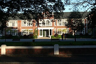
Christchurch West High School existed prior to 1966 on the site of Hagley College in Hagley Avenue, in Christchurch, New Zealand. In that year 'West' amalgamated with Technical High School to become Hagley High School. As part of that amalgamation, the maroon, black and white colours were changed to teal.

The Christchurch tramway system was an extensive network in Christchurch, New Zealand, with steam and horse trams from 1882. Electric trams ran from 1905 to 1954, when the last line from Cashmere to Papanui was replaced by buses.

Scott Brothers Limited was an engineering firm in Christchurch, New Zealand.

Hagley Oval is a cricket ground in Hagley Park in the central city of Christchurch, New Zealand. The first recorded match on the ground was in 1867, when Canterbury cricket team hosted Otago cricket team. Canterbury used the ground infrequently from then through until the 1920s, but hardly stopped during World War I.

Christchurch Central City or Christchurch City Centre is the geographical centre and the heart of Christchurch, New Zealand. It is defined as the area within the Four Avenues and thus includes the densely built up central city, some less dense surrounding areas of residential, educational and industrial usage, and green space including Hagley Park, the Christchurch Botanic Gardens and the Barbadoes Street Cemetery.
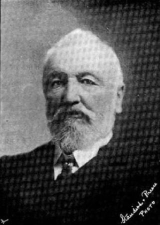
John Thomas Peacock MLC JP was a New Zealand businessman, philanthropist and politician. He came to Canterbury in 1844, several years before organised settlement started.
Christchurch tramway routes have developed from lines that were first established by a troika of private tramway companies in the latter part of the 19th century, through to a significantly expanded system under the municipal Christchurch Tramway Board, to the City Council-built heritage circuit. These routes have been worked by all three main forms of tramway motive power and have significantly contributed to the development of Christchurch City in New Zealand's South Island.
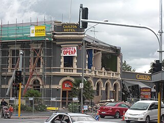
The Carlton Hotel in Christchurch was an historic pub on the corner of Papanui Road and Bealey Avenue. Built in 1906 for the New Zealand International Exhibition, it was registered by the New Zealand Historic Places Trust as a Category II heritage building. The building was damaged in the February 2011 Christchurch earthquake and demolished on 9 April 2011.

The Civic in Manchester Street, Christchurch Central City, was one of the former civic buildings of Christchurch City Council (CCC). Built in 1900, it was first used as an exhibition hall, a cinema and then a theatre. It burned down in 1917. The northern part of the building was purchased by CCC and opened as the civic office in 1924, and served this purpose until 1980. After that it had several uses, including a restaurant, bar and live music venue. The building was heavily damaged in the February 2011 Christchurch earthquake, and was demolished.

Clarendon Tower was a high rise building on Worcester Street at Oxford Terrace in the Christchurch Central City, New Zealand. Built on the site of the former Clarendon Hotel, the façade of the historic building was kept in the redevelopment and was protected by the New Zealand Historic Places Trust as a Category II heritage structure. Following damage from the February 2011 Christchurch earthquake, the 17-storey building has been demolished.

Mona Vale, with its homestead formerly known as Karewa, is a public park of 4 ha in the Christchurch suburb of Fendalton. The homestead and gate house are both listed as heritage buildings with Heritage New Zealand (NZHPT). The fernery and the rose garden, and pavilion with the setting of the park along the Avon River, add to the attractiveness of the property. It is one of the major tourist attractions of Christchurch.

The 16th New Zealand Parliament was a term of the New Zealand Parliament. It was elected at the 1905 general election in December of that year.

Joseph Clarkson Maddison was a New Zealand architect. He trained as an architect in his native London and came to Canterbury at the age of 22. At the end of the 19th and beginning of the 20th century, he was one of the most prominent architects in Christchurch, receiving commissions from all over the country. Until the February 2011 Christchurch earthquake, 13 of his buildings were listed by Heritage New Zealand on their register, with three of those Category I listings, but many of the Christchurch buildings have been demolished since. His style was plain and utilitarian, and he specialised in the classical Italian mode.
Latimer Square is an urban park in central Christchurch, New Zealand. It is located 400 metres (440 yd) east of the city's centre, Cathedral Square. Many commemorative events take place in Latimer Square. The square lies between the major urban thoroughfares of Gloucester Street and Worcester Street. Madras Street runs north and south to Latimer Square. The square is grassed and crossed by concrete paths and edged by mature trees. It covers an area of a little over 1.8 hectares.

The St Helens Hospitals were maternity hospitals located in seven New Zealand cities. They were the first state-run maternity hospitals in the world offering both midwifery services and midwifery training. The first hospital opened in 1905 in Wellington and the last one in Wanganui in 1921. The services of the St Helens Hospitals were gradually incorporated into other hospitals and the last hospital to close was in Auckland in 1990.

The Four Avenues are a group of four major arterial boulevards — Bealey Avenue, Fitzgerald Avenue, Moorhouse Avenue, and either Rolleston Ave or Deans Avenue — that surround the city centre of Christchurch, New Zealand. Serving as an inner ring road, they popularly form the limits of the city centre, separating it from the city's suburbs. Almost all of the city's commercial heart lies within the approximately rectangular 9.8-square-kilometre (3.8 sq mi) area formed by the four avenues. The term "within the Four Avenues" is widely used in Christchurch to refer to the central city. By extension, Christchurch as a whole is sometimes referred to as "The Four Avenues".