Related Research Articles
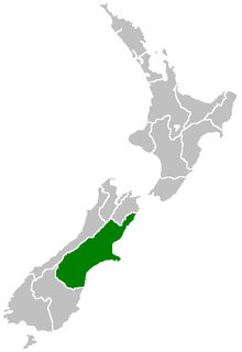
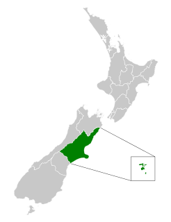
Canterbury is a region of New Zealand, located in the central-eastern South Island. The region covers an area of 44,508 square kilometres (17,185 sq mi), and is home to a population of 645,900.

The North Island, also officially named Te Ika-a-Māui, is one of the two main islands of New Zealand, separated from the larger but much less populous South Island by the Cook Strait. The island's area is 113,729 square kilometres (43,911 sq mi), making it the world's 14th-largest island. It has a population of 3,896,200, accounting for approximately 77% of the total residents of New Zealand.

Otago is a region of New Zealand located in the southern half of the South Island administered by the Otago Regional Council. It has an area of approximately 32,000 square kilometres (12,000 sq mi), making it the country's second largest local government region. Its population was 245,300 in June 2020.

The West Coast is a region of New Zealand on the west coast of the South Island that is administered by the West Coast Regional Council. It comprises the territorial authorities of Buller District, Grey District and Westland District. The principal towns are Westport, Greymouth, and Hokitika. The region is one of the more remote and most sparsely populated areas of the country.
Norsewood is a small rural settlement in the Tararua District and Manawatū-Whanganui region of New Zealand's North Island. The town is situated east of the Ruahine Mountain range and is located 20 kilometres northeast of Dannevirke.

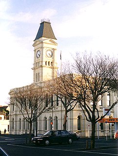
Timaru is a port city in the southern Canterbury region of New Zealand, located 157 kilometres (98 mi) southwest of Christchurch and about 196 kilometres (122 mi) northeast of Dunedin on the eastern Pacific coast of the South Island. The Timaru urban area is home to 28,700 people, and is the largest urban area in South Canterbury, and the second largest in the Canterbury Region overall, after Christchurch. The town is the seat of the Timaru District, which includes the surrounding rural area and the towns of Geraldine, Pleasant Point and Temuka, which combined have a total population of 48,400.

Christchurch is the largest city in the South Island of New Zealand and the seat of the Canterbury Region. The Christchurch urban area lies on the South Island's east coast, just north of Banks Peninsula. The urban area is home to 383,200 residents, and the territorial authority has 394,700 people, which makes it the second-most populous city in New Zealand after Auckland and before Wellington. The Avon River flows through the centre of the city, with an urban park located along its banks.

Richmond is a town and the seat of the Tasman District Council in New Zealand. It lies 13 kilometres (8 mi) south of Nelson in the South Island, close to the southern extremity of Tasman Bay / Te Tai-o-Aorere. The town, first settled by Europeans in 1842, was named in 1854 after the town of Richmond on Thames near London. The town has an estimated population of 17,250 as of June 2020.
Waitaki District is a territorial authority that is located in the Canterbury and Otago regions of the South Island of New Zealand. It straddles the traditional border between the two regions, the Waitaki River, and its seat is Oamaru.

Rolleston is the seat and largest town in the Selwyn District, in the Canterbury region of New Zealand's South Island. It is located on the Canterbury Plains 22 kilometres (14 mi) south-west of Christchurch, and is considered a satellite town of the city. The town has a population of 21,900, making it New Zealand's 26th largest urban area. It was nicknamed the "Town of the Future" in the 1970s by Prime Minister Norman Kirk. The "Town of the Future" signage has since been removed from the entrances to Rolleston.

Loburn is a rural community in North Canterbury, New Zealand. It is located ten kilometres northwest of Rangiora and nearly 50 kilometres north of Christchurch.

Waikuku is a small town in the Canterbury region of New Zealand, which sits 28 km north of central Christchurch. Waikuku lies 11.8 km south of Leithfield on state highway 1 and 3 km north of Woodend. In 1901 there were 86 people resident in Waikuku according to that year's census. Waikuku had a population of 900 people at the time of the 2013 Census, most of whom live in on the coast at Waikuku Beach. This has increased from 540 people in 1991. Waikuku is popular with both those that commute into work in Christchurch each day and with owners of holiday houses. Waikuku was home to rope and twine works. This business started off using flax from local swamps. It closed in 1987. The sandy beach and pine forests are popular with surfers, swimmers, campers and horse-riders, and the large estuary of the Ashley River hosts many species of birds. The Waikuku beach has been rated as one of the ten best to learn to surf at. Waikuku has an annual sand sculpture competition each January. There are four age categories in the judging of the sand sculptures and sand castles.
State Highway 71 is a New Zealand state highway connecting Kaiapoi/Christchurch with Rangiora.

Prebbleton is a small town in the Selwyn District in the Canterbury Region of New Zealand. It is 11 km southwest of the centre of Christchurch and about 2 km south of the outlying industrial suburb of Hornby.

The South Canterbury District Health Board is a district health board with the focus on providing healthcare to the Timaru, Mackenzie, Waimate districts in New Zealand.
The Canterbury District Health Board is a district health board with the focus on providing healthcare to the Canterbury region of New Zealand north of the Rangitata River. It is responsible for roughly 510,000 residents; or 12% of New Zealand's population. The Canterbury District Health Board covers a territory of 26,881 square kilometers and is divided between six territorial local authorities.
Pleasant Valley is a small locality near the town of Geraldine in the Canterbury Region of the South Island of New Zealand. The area is boarded by the Geraldine Downs to the north and Gapes Valley to the south. The Hae Hae Te Moana River runs through the valley.
Invercargill Central is the central business district and central suburb of Invercargill, in the Southland region of the South Island of New Zealand.
Waimataitai is a suburb of Timaru, in the South Canterbury district and Canterbury region of New Zealand's South Island.
Parkside is a suburb of Timaru, in the Timaru District and Canterbury Region of New Zealand's South Island.
References
- ↑ "Highfield North". stats.govt.nz. Statistics New Zealand.
- ↑ "Highfield South". stats.govt.nz. Statistics New Zealand.
- ↑ "Highfield Village Mall". southcanterbury.org.nz. South Canterbury Chamber of Commerce.
Coordinates: 44°23′23″S171°13′08″E / 44.389716°S 171.218902°E
| | This Canterbury Region-related geography article is a stub. You can help Wikipedia by expanding it. |