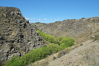
The Maerewhenua River, also known as the Marewhenua River, is a small river in the Otago region of New Zealand's South Island. It is located in North Otago and acts as a tributary of the Waitaki River, which forms the border between Otago and Canterbury.
Otago is a region of New Zealand in the south of the South Island administered by the Otago Regional Council. It has an area of approximately 32,000 square kilometres (12,000 sq mi), making it the country's third largest local government region. Its population was 229,200 in June 2018.
New Zealand is a sovereign island country in the southwestern Pacific Ocean. The country geographically comprises two main landmasses—the North Island, and the South Island —and around 600 smaller islands. New Zealand is situated some 2,000 kilometres (1,200 mi) east of Australia across the Tasman Sea and roughly 1,000 kilometres (600 mi) south of the Pacific island areas of New Caledonia, Fiji, and Tonga. Because of its remoteness, it was one of the last lands to be settled by humans. During its long period of isolation, New Zealand developed a distinct biodiversity of animal, fungal, and plant life. The country's varied topography and its sharp mountain peaks, such as the Southern Alps, owe much to the tectonic uplift of land and volcanic eruptions. New Zealand's capital city is Wellington, while its most populous city is Auckland.
The South Island, also officially named Te Waipounamu, is the larger of the two major islands of New Zealand in surface area; the other being the smaller but more populous North Island. It is bordered to the north by Cook Strait, to the west by the Tasman Sea, and to the south and east by the Pacific Ocean. The South Island covers 150,437 square kilometres (58,084 sq mi), making it the world's 12th-largest island. It has a temperate climate.
The river flows to the east of the small town of Duntroon. When the Kurow Branch, a branch linerailway, was under construction in the 1870s, the river posed construction difficulties and the line terminated on the east bank for over five years until a bridge was successfully completed in mid-1881.
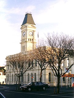
Duntroon is a small farming-town in the Waitaki District of New Zealand's South Island. Although traditionally considered a North Otago town, it is located as of 2018 within the farthest southern reaches of Canterbury. Just north of the town runs the Waitaki River, which forms the traditional border between the two regions, although the official border has moved south to put most of Waitaki District within Canterbury, including Duntroon. To the east of the village runs the Maerewhenua River. Near the village are the Earthquakes, a limestone-cliff formation.
The Kurow Branch was part of New Zealand's national rail network. In the North Otago region of the South Island, it was built in the 1870s to open up the land behind Oamaru for development, and closed in 1983.
A branch line is a secondary railway line which branches off a more important through route, usually a main line. A very short branch line may be called a spur line. David Blyth Hanna, the first president of the Canadian National Railway, said that although most branch lines cannot pay for themselves, they are essential to make main lines pay.
A geographic coordinate system is a coordinate system that enables every location on Earth to be specified by a set of numbers, letters or symbols. The coordinates are often chosen such that one of the numbers represents a vertical position and two or three of the numbers represent a horizontal position; alternatively, a geographic position may be expressed in a combined three-dimensional Cartesian vector. A common choice of coordinates is latitude, longitude and elevation. To specify a location on a plane requires a map projection.
This article about a river in the Otago region is a stub. You can help Wikipedia by expanding it.
Waitaki District is a territorial authority that is located in the Canterbury and Otago regions of the South Island of New Zealand, and it straddles the traditional border between the two regions, the Waitaki River.
The Taieri River is the fourth-longest river in New Zealand and is in Otago in the South Island. Rising in the Lammerlaw ranges, it initially flows north, then east around the Rock and Pillar range before turning southeast, reaching the sea 30 kilometres (19 mi) south of Dunedin.
The Tokomairaro River is located in Otago, New Zealand. It flows southeast for some 50 kilometres (30 mi), reaching the Pacific Ocean at Toko Mouth 50 kilometres (30 mi) south of Dunedin. The town of Milton is located on the Tokomairaro's floodplain, close to the junction of its two main branches.
The Shag River is located in Otago in the South Island of New Zealand. It rises in the Kakanui Range, flowing southeast for 50 kilometres (31 mi) before reaching the Pacific Ocean on the south side of Shag Point east of Palmerston. The Dunback Branch railway that operated from the 1880s to 1989 largely followed the route of the river from its junction with the Main South Line near Shag Point township to its terminus in Dunback.
The Manuherikia River is located in Otago in the South Island of New Zealand. It rises in the far north of the Maniototo, with the West Branch draining the eastern side of the St Bathans Range, and the East Branch draining the western flanks of the Hawkdun Range. The river continues southwest through the wide Manuherikia Valley to its confluence with the Clutha River at Alexandra. During the 1860s the Manuherikia was one of the centres of the Central Otago Gold Rush.
The Hopkins River is in the central South Island of New Zealand. It flows south for 40 kilometres (25 mi) from the Southern Alps into the northern end of Lake Ohau in the Mackenzie Country.
Aramoana is a small coastal settlement, 27 kilometres north of Dunedin city, in the South Island of New Zealand. The settlement's permanent population in 2001 Census was 261. Supplementing this are seasonal visitors from the city who occupy cribs. The name Aramoana is Maori for "pathway of the sea".
The Waimate Branch was a branch line railway built in southern Canterbury, New Zealand to link the Main South Line with the town of Waimate, the centre of the surrounding rural area. It opened in 1877 and operated until 1966; for some of this time, it included an extension to Waihao Downs that was known as the Waimate Gorge Branch or Waihao Downs Branch. When the line closed, Waimate received the dubious distinction of being New Zealand's first major town to lose its railway line.
The Outram Branch was a branch line railway near Dunedin, Otago that operated from 1877 to 1953 and formed part of New Zealand's national rail network.
Dunback, formerly Waihemo, is a small town in the Otago region of New Zealand. It is located between Palmerston and Ranfurly on Highway 85. It has a population of about 200 people. Most of these people live in the rural areas near the town. The only remaining buildings now that still stand are the church, the Highwayman Hotel, the coronation hall and the Dunback school. All of these buildings are over 100 years old. There is also the domain which includes a cricket field, camping ground and bowling green. Locals and campers both enjoy the facilities that it has to offer. Along Murphy Street also stands the swing bridge which was built in the early 1900s for pupils to cross the Shag River for easier access to the school.
Tokarahi is a small village located in the Otago region of the South Island of New Zealand. Its location is a rural setting in the Waiareka Valley, inland from Oamaru. Economic activity is focused on agriculture.
Hakataramea, spelt Hakateramea in some older sources, is a rural village located in the southern Canterbury region of New Zealand's South Island. It is in the Waimate District and sits on the north bank of the Waitaki River at its confluence with the Hakataramea River.
Glenpark is a lightly populated rural locality in the Otago region of New Zealand's South Island. It is northwest of Palmerston and is on the banks of the Shag River. To the west is the locality of Stoneburn.
Inch Valley is a lightly populated rural locality in the Otago region of New Zealand's South Island. It is northwest of Palmerston and Glenpark, east of Stoneburn, on the banks of the Shag River. Economic activity around Inch Valley is agricultural.
Kelso is an abandoned small settlement in Otago, New Zealand, located ten kilometres north of Tapanui on the Crookston Burn, close to its junction with the larger Pomahaka River. Its population during the 1960s and 1970s was close to 300, with most of its economy based on sheep farming. A small dairy factory was a focal point in the village's early years.
The settlement of Broad Bay is located on the Otago Harbour coast of Otago Peninsula, in the South Island of New Zealand. It is administered as part of the city of Dunedin, and is technically a suburb of that city, though its isolation and semi-rural nature make it appear as a settlement in its own right.
Sawyers Bay is a suburb of the New Zealand city of Dunedin. It is located 3 kilometres (1.9 mi) to the southwest of Port Chalmers in a wide valley on the shore of Mussel Bay, 13 kilometres (8.1 mi) to the northeast of Dunedin city centre.
The Blue Line, of the St. Louis MetroLink, is a light rail service - operating between 24 stations in Greater St. Louis. It is the newest line in the system.
Halfway Bush is a suburb of the New Zealand city of Dunedin. It is located 3 kilometres (1.9 mi) to the northwest of the city centre, close to the point at which Taieri Road becomes the winding rural Three Mile Hill Road. It was this road which gave the suburb its name, as this locality was halfway between the Taieri Plains and central Dunedin in the early days of European settlement, when Three Mile Hill was the main route from Dunedin to the Otago hinterland. This route was superseded by the route through the Caversham Valley in the 1860s.
The Poolburn Gorge is a gorge located in the Central Otago region of the South Island of New Zealand, 4 km east of the small settlement of Lauder. The Ida Burn flows through the 2.5 km long canyon across the Raggedy Range between the Ida Valley and the Manuherikia Valley. There are no public roads through the gorge; only the track of the former Otago Central Railway, now used as the Otago Central Rail Trail, follows the river on the southern flanks of the gorge.
This page is based on this Wikipedia article Text is available under the CC BY-SA 4.0 license; additional terms may apply. Images, videos and audio are available under their respective licenses.