Poolburn Gorge

Last updated
View up Poolburn Gorge in spring (Poolburn tunnel No.1 visible on the far right) View up Poolburn Gorge 2.jpg
View up Poolburn Gorge in spring (Poolburn tunnel No.1 visible on the far right)

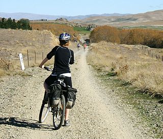
The Poolburn Gorge is a gorge located in the Central Otago region of the South Island of New Zealand, 4 km east of the small settlement of Lauder. The Ida Burn flows through the 2.5 km long canyon across the Raggedy Range between the Ida Valley and the Manuherikia Valley. There are no public roads through the gorge; only the track of the former Otago Central Railway, now used as the Otago Central Rail Trail, [1] follows the river on the southern flanks of the gorge.

Central Otago is located in the inland part of the Otago region in the South Island of New Zealand. The motto for the area is "A World of Difference".

South Island Southernmost of the two main islands in New Zealand

The South Island, also officially named Te Waipounamu, is the larger of the two major islands of New Zealand in surface area; the other being the smaller but more populous North Island. It is bordered to the north by Cook Strait, to the west by the Tasman Sea, and to the south and east by the Pacific Ocean. The South Island covers 150,437 square kilometres (58,084 sq mi), making it the world's 12th-largest island. It has a temperate climate.

New Zealand Country in Oceania

New Zealand is a sovereign island country in the southwestern Pacific Ocean. The country geographically comprises two main landmasses—the North Island, and the South Island —and around 600 smaller islands. New Zealand is situated some 2,000 kilometres (1,200 mi) east of Australia across the Tasman Sea and roughly 1,000 kilometres (600 mi) south of the Pacific island areas of New Caledonia, Fiji, and Tonga. Because of its remoteness, it was one of the last lands to be settled by humans. During its long period of isolation, New Zealand developed a distinct biodiversity of animal, fungal, and plant life. The country's varied topography and its sharp mountain peaks, such as the Southern Alps, owe much to the tectonic uplift of land and volcanic eruptions. New Zealand's capital city is Wellington, while its most populous city is Auckland.

Contents

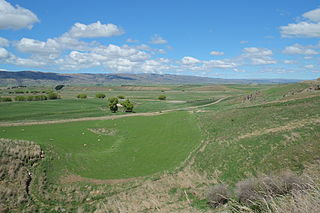
The landscape surrounding Poolburn Gorge is barren and dry, shaped by the typical Central Otago climate of dry hot summers and cold winters. The gorge cuts through schist rock bluffs, with the vegetation on the steep slopes consisting of tussock and hardy low-growing shrubs. Contrasting this, a ribbon of lush trees lines the immediate river banks at the bottom of the gorge. The Ida Burn joins the Manuherikia River shortly after it emerges from the Poolburn Gorge into the Manuherikia Valley.

Tussock grasslands of New Zealand

Tussock grasslands form expansive and distinctive landscapes in the South Island and to a lesser extent in the central plateau region of the North Island of New Zealand. Most of the plants referred to as tussocks are in the genera Carex, Chionochloa, Festuca, and Poa.

Manuherikia River river in New Zealand

The Manuherikia River is located in Otago in the South Island of New Zealand. It rises in the far north of the Maniototo, with the West Branch draining the eastern side of the St Bathans Range, and the East Branch draining the western flanks of the Hawkdun Range. The river continues southwest through the wide Manuherikia Valley to its confluence with the Clutha River at Alexandra. During the 1860s the Manuherikia was one of the centres of the Central Otago Gold Rush.

The Pool Burn was known to southern Māori as Te Waipapapa o Karetai - the water container of Karetai, a Ngāi Tahu chief. [2]

Māori people Indigenous Polynesian people of New Zealand

The Māori are the indigenous Polynesian people of New Zealand. Māori originated with settlers from eastern Polynesia, who arrived in New Zealand in several waves of canoe voyages some time between 1250 and 1300. Over several centuries in isolation, the Polynesian settlers developed a unique culture, with their own language, a rich mythology, and distinctive crafts and performing arts. Early Māori formed tribal groups based on eastern Polynesian social customs and organisation. Horticulture flourished using plants they introduced; later, a prominent warrior culture emerged.

Ngāi Tahu Māori iwi (tribe) in Aotearoa New Zealand

Ngāi Tahu, or Kāi Tahu, is the principal Māori iwi (tribe) of the southern region of New Zealand. Its takiwā is the largest in New Zealand, and extends from Blenheim, Mount Mahanga and Kahurangi Point in the north to Stewart Island in the south. The takiwā comprises 18 rūnanga corresponding to traditional settlements.

Otago Central Railway and Rail Trail

The Poolburn Gorge section of the Otago Central Branch Railway encompasses two bridges and two tunnels, and gently snakes along the true left (south side) of the gorge. The construction of the railway line through the gorge took over three years, with up to 300 workers employed at the peak of construction around 1902. [3]

Poolburn Viaduct Poolburn Viaduct.jpg
Poolburn Viaduct

At the eastern entrance to the gorge, the 37 m (121 ft) tall Poolburn Viaduct is the highest bridge on the rail line, and is bridge No.69 starting from Dunedin. Built from 1901 to 1904, the 108 m (354 ft) long viaduct was the last big masonry pier bridge with steel trusses built on the line. It has the longest center span on the Otago Central Railway at 47.5 m (156 ft) long. Schist quarried from outcrops close by was trimmed and bolstered to construct the piers and abutments with the help of large gantry hoists to lift and position the stone slabs. [4]

Dunedin City in Otago, New Zealand

Dunedin is the second-largest city in the South Island of New Zealand, and the principal city of the Otago region. Its name comes from Dùn Èideann, the Scottish Gaelic name for Edinburgh, the capital of Scotland.

Entrance of Poolburn tunnel No.2 Poolburn tunnel number 2 north entrance.jpg
Entrance of Poolburn tunnel No.2

Shortly into the gorge, two tunnels have been cut through schist rock bluffs. Poolburn No.1 is 201 m (659 ft) long, and the curved Poolburn No.2 is the longest tunnel on the line at 229 m (751 ft) long. Torches are needed to walk or cycle through these tunnels (typically provided with hired bikes). Both tunnels feature portals with bolstered schist slab facings, with the arches outlined in brick. The inside walls of the tunnels are lined with brick about 10 m (33 ft) into the tunnels; afterwards the walls are just the bare rock.

Shortly after exiting the Poolburn Gorge, the track crosses the Manuherikia River on the 110.6 m (363 ft) long Manuherikia Bridge No.1 (number 70 on the Otago Central Railway line). This concrete pier bridge is the longest on the line and was completed in 1903. It is one of only two curved bridges on the rail trail, the other being in Hyde. [5]

In 1990, the railway line was closed from Middlemarch onwards, which includes the Poolburn Gorge section. The tracks were lifted, and later in 2000, the line was converted to a bike trail, which included re-decking both bridges with timber and re-surfacing the track with fine gravel.

The Poolburn Gorge section of the Otago Central Railway is the most popular section of this multi-day bike track. [6] The gorge can be traversed by bike as a day trip from Oturehua to Omakau, or in 1–2 hours from Auripo to Omakau, or as a 3-4 hour return bike trip from Omakau. [7] Local operators in Omakau and Oturehua provide bike hire and transport, with both villages offering accommodation options as well.

The bike track gently descends through the scenic Poolburn Gorge from east to west and takes in the Poolburn Viaduct, the two tunnels cut through schist rock, and the bridge over the Manuherikia River. Just after the second tunnel, two short walking tracks can be explored - one to the bluff above the tunnel portal, the other to the remnants of a construction worker village. After the rail trail exits the gorge, it offers good views over the Manuherikia Valley and towards the Hawkdun Range.

Related Research Articles

Maniototo

The Maniototo Plain, usually simply known as The Maniototo, is an elevated inland region in Otago, New Zealand. The region roughly surrounds the upper reaches of the Taieri River and the Manuherikia River. It is bounded by the Kakanui Range to the north and the Rock and Pillar Range to the southeast. It has a harsh, dry climate, ranging from over 30 °C in mid-summer to -15 °C in mid-winter.

Dunedin Railways

The Dunedin Railways is an operator of a railway line and tourist trains based at Dunedin Railway Station in the South Island of New Zealand. The railway is a council-controlled trading organisation owned jointly by the Dunedin City Council and the Otago Excursion Train Trust.

Otago Central Rail Trail New Zealand rail trail

The Otago Central Rail Trail is a 150-kilometre walking, cycling and horse riding track in the South Island of New Zealand. A pioneering project for New Zealand, the successful cycle trail joined the New Zealand Cycle Trail umbrella organisation in 2012, having been one of the inspirations for it.

Lapstone Zig Zag

The Lapstone Zig Zag was a zig zag railway built near Lapstone on the Main Western line of New South Wales in Australia between 1863 and 1865, to overcome an otherwise insurmountable climb up the eastern side of the Blue Mountains. The ruling grade was already very steep at 1 in 33 (3%). Another of the early plans had been to build the whole line across the Blue Mountains on a completely different route through the Grose Valley with a 3-kilometre-long (1.9 mi) tunnel, but this was beyond the resources of the colony of New South Wales at the time. The track included the Knapsack Viaduct and a now abandoned station called Lucasville which was built for the Minister for Mines, John Lucas who had a holiday home nearby, the station opened in 1877.

Omakau human settlement in New Zealand

Omakau is a settlement in Central Otago, New Zealand, located between Alexandra and Ranfurly on the northwest bank of the Manuherikia River. The smaller settlement of Ophir, New Zealand is located on the opposite bank, three kilometres to the southeast.

Midland Line, New Zealand

The Midland line is a 212km section of railway between Rolleston and Greymouth in the South Island of New Zealand. The line features five major bridges, five viaducts and 17 tunnels, the longest of which is the Otira tunnel. It is the route of the popular TranzAlpine passenger train.

Otago Central Railway Branch railway line in Otago, New Zealand

The Otago Central Railway (OCR) or in later years Otago Central Branch Railway, now often referred to as the Taieri Gorge Railway, was a secondary railway line in Central Otago, in the South Island of New Zealand.

The Roxburgh Branch was a branch line railway built in the Otago region of New Zealand's South Island that formed part of the country's national rail network. Originally known as the Lawrence Branch, it was one of the longest construction projects in New Zealand railway history, beginning in the 1870s and not finished until 1928. The full line was closed in 1968.

Waipiata is an historic place on the Otago Central Rail Trail, in Central Otago, New Zealand.

Oturehua Township in Otago, New Zealand

The township of Oturehua is in the Ida Valley of the Maniototo, in Central Otago, in the South Island of New Zealand.

Albula Railway railway line

The Albula Railway is a single track metre gauge railway line forming part of the so-called core network of the Rhaetian Railway (RhB), in the Canton of Graubünden, Switzerland. It links Thusis on the Hinterrhein with the spa resort of St. Moritz in Engadine.

Castielertobel Viaduct arch bridge

The Castielertobel Viaduct is a single track railway bridge spanning the Castielertobelbach, and linking the municipalities of Castiel and Calfreisen, in the Canton of Graubünden, Switzerland. It was built between 1913 and 1914 for the Chur–Arosa railway, and is now owned and used by the Rhaetian Railway.

Ida Valley human settlement in New Zealand

The Ida Valley lies east of the Manuherikia Valley in Central Otago, New Zealand. At an altitude of around 500 m (1,600 ft), the 40 km long flat and wide valley is a relatively dry region with cold winters and hot summers, much like the rest of Central Otago. The majority of agricultural production in the Ida Valley is lamb, including merino, and also stud cattle. The valley is named after the Ida Burn, which joins the Poolburn and breaks through the Raggedy Range via the Poolburn Gorge.

Seven Arches Bridge (Newport)

The Seven Arches Bridge is a historic bridge in Newport, County Mayo, Ireland.

Poolburn Reservoir

Poolburn Reservoir, also known as Poolburn Dam, is a reservoir in Central Otago. Built during the Great Depression for irrigation but also as an employment initiative, the water is used by farmers in the Ida Valley.

Lauder, New Zealand

Lauder is a small settlement in the Otago Region of the South Island of New Zealand. It is located in Central Otago, 8 km northeast of Omakau, on the main route between Alexandra and Ranfurly, State Highway 85. The settlement was named after the town of the same name in southern Scotland, one of many Otago sites to be named after places in the Scottish borders by John Turnbull Thomson.

Makatote Viaduct Viaduct in New Zealand

The Makatote Viaduct takes the North Island Main Trunk railway (NIMT) across the Makatote River. It is 335.7 km (208.6 mi) from Wellington, at the foot of Ruapehu, in northern Manawatu-Wanganui, between National Park and Ohakune.

References

  1. Otago Central Rail Trail (from the New Zealand Department of Conservation website. Accessed 2014-02-18.)
  2. Information contained on a Department of Conservation information panel at Poolburn Gorge
  3. "The Otago Central Line". Otago Witness . 21 May 1902. Retrieved 18 February 2014.
  4. Information contained on an Otago Central Rail Trust information panel at Poolburn Viaduct
  5. Information contained on an Otago Central Rail Trust information panel at Manuherikia Viaduct
  6. "Rail trail still proving popular". Otago Daily Times . 23 May 2011. Retrieved 18 February 2014.
  7. "Poolburn Gorge day trips" . Retrieved 18 February 2014.

Commons-logo.svg Media related to Poolburn Gorge at Wikimedia Commons

Coordinates: 45°03′11″S169°44′06″E / 45.053°S 169.735°E / -45.053; 169.735