
Lawrence is a small town of 474 inhabitants in Otago, in New Zealand's South Island. It is located on State Highway 8, the main route from Dunedin to the inland towns of Queenstown and Alexandra. It lies 35 kilometres to the northwest of Milton, 11 kilometres northwest of Waitahuna, and close to the Tuapeka River, a tributary of the Clutha.
The Tuapeka River is located in Otago in the South Island of New Zealand. It is a tributary of the Clutha River, which it joins at Tuapeka Mouth between Roxburgh and Balclutha.

Berwick Forest is a large Pinus radiata (Pine) plantation at Berwick in New Zealand, around 40 km west of Dunedin. The forest lies close to the banks of the Waipori River immediately below and around the western end of Lake Mahinerangi, and consists of three blocks - the main block, Maungatua, and Waitahuna, with a total area of 13,141 hectares. The land is owned by Otago Land Company, a sub company of Boston-based investment company GMO LLC, the trees by Wenita Forest Products, which has shareholders Sinotrans (62%), the Chinese shipping company, and GMO.

Clutha District is a local government district of southern New Zealand, with its headquarters in the Otago town of Balclutha. The Clutha District has a land area of 6,362.86 km² and a 2006 census population of 16,839 usual residents. Clutha District occupies the majority of the geographical area known as South Otago.
Inch Clutha is a large, flat island sitting in the delta between the Matau (northern) and Koau (southern) branches of the Clutha River, downstream from the town of Balclutha in the South Island of New Zealand. Approximately 10 kilometres (6 mi) long and 3 kilometres (2 mi) wide, the fertile but flood-prone land of the island is extensively farmed. The island was formed in 1878 after a massive flood changed the course of the Clutha, which had formerly reached the ocean 4 km to the south at Port Molyneux.
The Pomahaka River is in South Otago in New Zealand's South Island. It is a tributary of the Clutha River, flowing south for 80 kilometres (50 mi) from the Old Man Range of mountains to join the Clutha just north of Balclutha. Along its path it passes the Blue Mountains and the forestry town of Tapanui in the area known locally as West Otago.
Romahapa is a locality in the Catlins region of Otago in New Zealand's South Island. It is located between the towns of Balclutha and Owaka. The last shop closed in 1977.
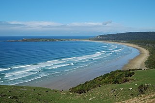
Pounawea is a small settlement in The Catlins, an area of the southern South Island of New Zealand. It is located four kilometres southwest of Owaka, at the mouth of the Catlins River. It is a popular holiday spot with a seasonal population, there are numerous cribs at the settlement.
Tautuku Peninsula is a rocky headland in the Catlins on the south coast of Otago on the South Island of New Zealand. It is located 25 km (15 mi) east of Waikawa, at the western end of Tautuku Bay.
Tahakopa is a small settlement in The Catlins, an area of the southern South Island of New Zealand. It is located 25 kilometres northeast of Waikawa on the Tahakopa River. On 17 February 1915, Tahakopa became the terminus of the Catlins River Branch railway and retained this status until the branch line was closed on 27 February 1971. From the line's opening until 12 August 1956, a railway locomotive depot was based in the village. The old station building and goods shed still stand today.
The Waikawa River flows east then south through the Catlins, an area of the southern South Island of New Zealand. Its total length is 23 kilometres (14 mi), and it flows into the Pacific Ocean at Waikawa. Close to its mouth, it cascades over a small series of cataracts, ironically named Niagara Falls.

Waitahuna is a small rural hamlet in the Otago region of New Zealand's South Island. It is 10 kilometres (6.2 mi) from Lawrence.
Otanomomo is a locality in the South Otago region of New Zealand's South Island. It is situated on the banks of the Clutha River, roughly 6 km south of Balclutha. Nearby settlements include Finegand to the north, Paretai, Puerua, and Romahapa to the south, and Waitepeka to the west.
The Fleming River is a river of the eastern Catlins, New Zealand. A tributary of the Tautuku River, it rises west of Soaker Hill in the Maclennan Range and flows south-eastward through the Catlins Forest Park to join that river at Tautuku.

The Mahitahi River is a river of the southwest of New Zealand's South Island. It flows northwest from the Hooker Range, part of the Southern Alps, reaching the Tasman Sea at Bruce Bay.
The Puerua River is a river in South Otago, New Zealand. A tributary of the Clutha River, it rises east of Brown Dome and flows eastward to join that river near Port Molyneux.
The Waipati River, alternatively known as the Chaslands River is a river in the eastern Catlins, New Zealand. It rises in the Maclennan Range and flows south-eastward into the Waipati Beach north of Chaslands Mistake.
Garrard Glacier is a glacier in the Queen Alexandra Range of Antarctica, draining eastward from the névé between Mount Lockwood and Mount Kirkpatrick and entering Beardmore Glacier south of Bell Bluff. It appears that the British Antarctic Expedition, 1910–13, applied the name "Garrard Glacier" to the feature which had been named Bingley Glacier by Ernest Shackleton in 1908. The area was surveyed by the New Zealand Geological Survey Antarctic Expedition (1961–62), who retained Bingley Glacier on the basis of priority and reapplied the name Garrard Glacier to this previously unnamed feature. The name is for Apsley Cherry-Garrard, a zoologist with the British Antarctic Expedition.
The Burke River, a watercourse that is part of the Nepean River catchment, is located in the Southern Highlands of New South Wales, Australia.
The small settlement of Caberfeidh is located in The Catlins, in the Otago region of New Zealand's South Island. The site of a former railway station on the Catlins Branch Line, it is sited close to a tributary of the Maclennan River, 5 kilometres north of the coast at Tahakopa Bay and 12 kilometres southwest of Owaka.


