The Marlborough Region, commonly known simply as Marlborough, is one of the regions of New Zealand, located in the northeast of the South Island. Marlborough is a unitary authority, both a region and a district, and its council is located at Blenheim. It has a population of 46,600.
The South Island, also officially named Te Waipounamu, is the larger of the two major islands of New Zealand in surface area; the other being the smaller but more populous North Island. It is bordered to the north by Cook Strait, to the west by the Tasman Sea, and to the south and east by the Pacific Ocean. The South Island covers 150,437 square kilometres (58,084 sq mi), making it the world's 12th-largest island. It has a temperate climate.
Ward is a small town in Marlborough, New Zealand, with a population of about 900 residents. It is located on State Highway 1, 82 kilometres (51 mi) north of Kaikoura. The Flaxbourne River flows past to the north and into the Pacific Ocean to the south-east of Ward. A current initiative aims to have the town renamed as Flaxbourne.
For over a decade, Wharanui was the southern terminus of a railway that ran from Picton south through Blenheim. The railway reached Wharanui by 1915. It was intended to continue the line southwards via Kaikoura to a line being built north from Christchurch that had its current terminus in Parnassus, but World War I stopped construction and Wharanui remained the southern terminus of the isolated Blenheim section. Work south from Wharanui did not recommence until 1928, and delays caused by the Great Depression and World War II meant the line was not completed until 1945. Wharanui railway station is still in use today, primarily as the southern base for bank engines used to help heavy trains on the line from Picton.
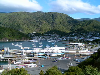
Picton is a town in the Marlborough Region of New Zealand's South Island. The town is located near the head of the Queen Charlotte Sound, 25 km (16 mi) north of Blenheim and 65 km (40 mi) west of Wellington. Waikawa lies just north-east of Picton, and is often considered to be contiguous part of Picton.
Blenheim is the most populous town in the region of Marlborough, in the north east of the South Island of New Zealand. It has an urban population of 31,600. The surrounding area is well known as the centre of New Zealand's wine industry. It enjoys one of New Zealand's sunniest climates, with warm, relatively dry summers and cool, crisp winters.
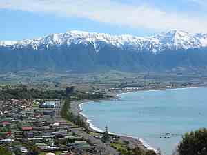
Kaikoura is a town on the east coast of the South Island of New Zealand. It is located on State Highway 1, 180 km north of Christchurch.
A small church is located in Wharanui, called St Oswald's Church. This was slightly damaged in the 2016 earthquake, the future remains uncertain.
Oswald was King of Northumbria from 634 until his death, and is venerated as a saint, of whom there was a particular cult in the Middle Ages.
A geographic coordinate system is a coordinate system that enables every location on Earth to be specified by a set of numbers, letters or symbols. The coordinates are often chosen such that one of the numbers represents a vertical position and two or three of the numbers represent a horizontal position; alternatively, a geographic position may be expressed in a combined three-dimensional Cartesian vector. A common choice of coordinates is latitude, longitude and elevation. To specify a location on a plane requires a map projection.
Althorpe is a small village in North Lincolnshire, England, four miles (6 km) west of Scunthorpe and the same distance south-east of Crowle, on the A18 road. The population details are included in the civil parish of Keadby with Althorpe.
The Main North Line between Picton and Christchurch and the Main South Line between Lyttelton and Invercargill, running down the east coast of the South Island of New Zealand, are sometimes together referred-to collectively as the South Island Main Trunk Railway (SIMT). Construction of a line running the length of the east coast began in the 1860s and was completed all the way from Picton to Invercargill in 1945; the last sections being on the Main North Line south of Picton. But the designation 'South Island Main Trunk' originally referred to only that line between Christchurch and Invercargill.
Picton is a hamlet and civil parish located in the north of North Yorkshire, England. It is situated approximately 4 miles (6 km) south from Yarm, 8 miles (13 km) south from Middlesbrough, and just over 1 mile (1.6 km) west from the A19 road. The name of the village derives from Old English and means "Pica's farm or settlement." Up until the 1850s, the village was spelt as Pickton with the old spelling being cut into the Picton Liberty stone which marked the boundary between the parishes of Picton and Kirklevington.
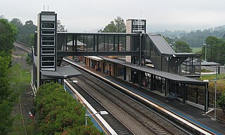
The Picton railway station is a heritage-listed railway station located on the Main South line in the south-western Sydney suburb of Picton in the Wollondilly Shire local government area of New South Wales, Australia. It was built from 1863 to 1919. It is also known as the Picton Railway Station group. The property is owned by RailCorp, an agency of the Government of New South Wales. It was added to the New South Wales State Heritage Register on 2 April 1999. The station opened on 1 July 1869. The station is unusually sited, with southbound journeys actually heading north out of the station before traversing a 225 degree horseshoe curve to again head south, and likewise northbound services heading south before rounding a number of curves to resume their true direction.
Glenomaru is a small settlement in The Catlins, an area of the southern South Island of New Zealand. It is located 10 kilometres north of Owaka on the main road to Balclutha. On 7 July 1891, a branch line railway from the Main South Line in Balclutha was opened to Glenomaru, and the village remained the terminus of the line until it was extended to Tahora on 16 December 1895. This line ultimately terminated in Tahakopa and was known as the Catlins River Branch. It closed on 27 February 1971 and a sawmill now exists on the site of Glenomaru station, though some of the railway's old formation can be seen in the surrounding area and the Hunts Road tunnel is in the vicinity and can be walked.
The Coastal Pacific is a long-distance passenger train that runs between Picton and Christchurch in the South Island of New Zealand. It is operated by The Great Journeys of New Zealand division of KiwiRail. It was called the TranzCoastal from May 2000 until temporarily withdrawn in February 2011. It was the first train to use the new AK class carriages.
The Waiau Branch was a branch line railway in the northern Canterbury region of New Zealand's South Island. Known as the Great Northern Railway for its first few decades of life, the Waiau Branch was seen as part of a main line north but was ultimately superseded by a coastal route. Opened in stages from 1882 to 1919, the line closed in 1978 but a portion has been retained as the Weka Pass Railway.
Culverden is a small town in the northern Canterbury region of New Zealand's South Island. In the 2013 New Zealand census, the town had a usually resident population of 426.
The Main North Line, sometimes referred to as part of the South Island Main Trunk Railway, is a railway line that runs north from Christchurch in New Zealand up the east coast of the South Island through Kaikoura and Blenheim to Picton. It is a major link in New Zealand's national rail network and offers a connection with roll-on roll-off ferries from Picton to Wellington. It was also the longest railway construction project in New Zealand's history, with the first stages built in the 1870s and not completed until 1945.
Hundalee is a rural locality in the Hurunui District of the Canterbury region of New Zealand's South Island. It straddles the Conway River, the traditional boundary between Canterbury and Marlborough and is in the Hundalee Hills.
The Lynx Express was a long-distance passenger train in the South Island of New Zealand that ran the length of the Main North Line between Picton and Christchurch. The service was operated by New Zealand Rail Limited business unit InterCity Rail.
The Picton Express was a passenger express train operated by the New Zealand Railways Department between Christchurch and Picton. It ran from December 1945 until February 1956, and was thus the shortest-lived provincial express in New Zealand.
Colo Vale is a Northern Village of the Southern Highlands of New South Wales, Australia, in Wingecarribee Shire. Colo Vale is approximate 100km south west on the Hume Highway from Sydney. It is situated 2 km north-west of Aylmerton, 5 km from the Hume Highway and 12 km drive to Mittagong. At the 2016 census, Colo Vale had a population of 1,618. The surrounding area is part of the Parish of Colo which includes the villages of Aylmerton, Willow Vale, Alpine and Yerrinbool. Colo Vale has a mixed-business general store and many home-based businesses, including hairdressers, small manufacturing businesses and a large native plant nursery and a Public School on Wattle Street. A large sporting oval is located adjacent to the school with tennis courts, a community hall and a Rural Fire Service station.[2]
The Hookhamsnyvy Creek is a natural watercourse in the northern Canterbury region of New Zealand's South Island.
Marlborough Lines Limited is an electricity distribution company, based in Blenheim, New Zealand.
The 2016 Kaikoura earthquake was a magnitude 7.8 (Mw) earthquake in the South Island of New Zealand that occurred two minutes after midnight on 14 November 2016 NZDT. Ruptures occurred on multiple faults and the earthquake has been described as the "most complex earthquake ever studied".
This page is based on this Wikipedia article Text is available under the CC BY-SA 4.0 license; additional terms may apply. Images, videos and audio are available under their respective licenses.