Mayfield, Blenheim

Last updated

Mayfield
Autumn Scene at Pollard Park (7368025342).jpg
Pollard Park
Mayfield, Blenheim
Coordinates: 41°30′12″S173°57′12″E / 41.503333°S 173.953398°E / -41.503333; 173.953398
CountryNew Zealand
City Blenheim, New Zealand
Local authority Marlborough District Council
Electoral ward
  • Blenheim General Ward
  • Marlborough Māori Ward
Area
[1]
  Land146 ha (361 acres)
Population
 (June 2023) [2]
  Total1,840
Thomsons Ford Grovetown
Springlands
Pfeil oben.svg
Pfeil links.svgMayfieldPfeil rechts.svg
Pfeil unten.svg
Riversdale
Redwoodtown Blenheim Central Islington

Mayfield is a suburb to the north of Blenheim's central district, in the Marlborough region of the South Island of New Zealand. [3] [4] Pollard Park and Lansdowne Park are large parks to the west and north of the suburb, and a racecourse lies to the northwest.

Contents

Demographics

Mayfield covers 1.46 km2 (0.56 sq mi). [1] It had an estimated population of 1,840 as of June 2023, with a population density of 1,260 people per km2.

Historical population
YearPop.±% p.a.
20061,470    
20131,539+0.66%
20181,674+1.70%
Source: [5]

Mayfield had a population of 1,674 at the 2018 New Zealand census, an increase of 135 people (8.8%) since the 2013 census, and an increase of 204 people (13.9%) since the 2006 census. There were 660 households, comprising 852 males and 822 females, giving a sex ratio of 1.04 males per female. The median age was 38.2 years (compared with 37.4 years nationally), with 324 people (19.4%) aged under 15 years, 303 (18.1%) aged 15 to 29, 768 (45.9%) aged 30 to 64, and 279 (16.7%) aged 65 or older.

Ethnicities were 77.1% European/Pākehā, 20.3% Māori, 3.9% Pasifika, 10.4% Asian, and 2.5% other ethnicities. People may identify with more than one ethnicity.

The percentage of people born overseas was 19.4, compared with 27.1% nationally.

Although some people chose not to answer the census's question about religious affiliation, 52.0% had no religion, 31.4% were Christian, 1.3% had Māori religious beliefs, 2.2% were Hindu, 0.2% were Muslim, 0.9% were Buddhist and 3.0% had other religions.

Of those at least 15 years old, 144 (10.7%) people had a bachelor's or higher degree, and 348 (25.8%) people had no formal qualifications. The median income was $29,400, compared with $31,800 nationally. 111 people (8.2%) earned over $70,000 compared to 17.2% nationally. The employment status of those at least 15 was that 696 (51.6%) people were employed full-time, 222 (16.4%) were part-time, and 54 (4.0%) were unemployed. [5]

Education

Mayfield School is a coeducational contributing primary (years 1–6) school with a roll of 92 students as of February 2024. [6] [7]

Related Research Articles

<span class="mw-page-title-main">Rapaura</span> Locality in Marlborough, New Zealand

Rapaura is a locality northwest of Blenheim, New Zealand. The Wairau River flows past to the north. Spring Creek lies to the east.

Ngamatapouri is a small rural locality in the Waitōtara River valley, 47 km north of Waitōtara village, in south Taranaki, New Zealand. Wanganui is about 80 km to the southeast. The road is sealed as far as the school.

<span class="mw-page-title-main">Frankleigh Park</span> Suburb of New Plymouth, New Zealand

Frankleigh Park is a suburb of New Plymouth, in the western North Island of New Zealand. It is located to the south of the city centre. The suburb is built around the site of early settler Henry King's farm, Woodleigh, the father of William Cutfield King.

Rahotu is a community in the west of Taranaki, in the North Island of New Zealand. It is located on State Highway 45, 16 kilometres north of Ōpunake and 11 km south of Warea.

Pukepoto is a town in Northland, New Zealand. It lies south west of Kaitaia and north east of Ahipara. The Herekino Forest lies to the south east.

Panguru is a community in the northern Hokianga harbour, in Northland, New Zealand. The Whakarapa Stream flows from the Panguru Range in the Warawara Forest to the west, through Panguru and into the Hokianga.

Te Rerenga is a locality on the Whangapoua Harbour, Coromandel Peninsula, New Zealand. State Highway 25 runs through it. Coromandel is 12 km to the west. Whitianga lies to the south east. The Waitekuri and Opitonui Rivers flow from the Coromandel Range in the west and south through the area to drain in the Whangapoua Harbour.

Maromaku is a locality in the Northland Region of the North Island of New Zealand. Kawakawa is north, and Towai is southeast. State Highway 1 runs past Maromaku to the north, and the North Auckland Line runs through it.

Karetu is a community in the Northland Region of the North Island of New Zealand. Kawakawa is to the west, and Waikare is northeast. The Karetu River flows from the Russell Forest in the southeast through Karetu, and joins the Kawakawa River shortly before it flows into the Bay of Islands.

Motatau or Mōtatau is a locality in the Northland Region of the North Island of New Zealand. Maromaku is to the east. The Taikirau Stream flows from east through Motatau and then runs northwest to join the Waiharakeke Stream. The North Auckland Line runs through Motatau.

Otaika is a suburb of Whangārei 7 km south of the city in Northland, New Zealand. The Otaika Stream runs from the north west, through the area, and into the Whangārei Harbour. State Highway 1 runs through the locality. The hill Tikorangi lies to the South. Tikorangi is a source of limestone for Portland Cement.

<span class="mw-page-title-main">Waikawa, Marlborough</span> Settlement in Marlborough, New Zealand

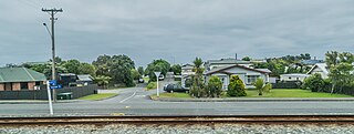
Waikawa is a small settlement to the north east of Picton, Marlborough, New Zealand. Waikawa Bay opens onto Queen Charlotte Sound.

Ohangai is a locality in South Taranaki, New Zealand. It is approximately 10 km east of Hāwera and 6 km north of Mokoia

Rawhitiroa is a locality situated in South Taranaki, New Zealand. It is positioned approximately 6.5 km east of Eltham.

<span class="mw-page-title-main">Ravensbourne, New Zealand</span> Suburb of Dunedin, New Zealand

Ravensbourne is a suburb of the New Zealand city of Dunedin. It is located on Otago Harbour on the steep southeastern slopes of Signal Hill. It lies on the harbour's northern shore, 4.5 kilometres (2.8 mi) east-northeast of the city centre.

<span class="mw-page-title-main">Karoro, New Zealand</span> Suburb of Greymouth, New Zealand

Karoro is a suburb to the south-west of Greymouth on the West Coast of New Zealand.

<span class="mw-page-title-main">Blaketown</span> Suburb of Greymouth, New Zealand

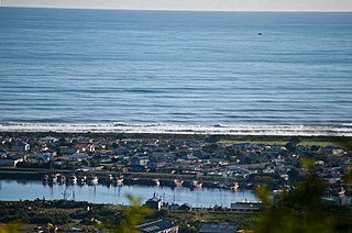
Blaketown is a suburb to the west of Greymouth on the West Coast of New Zealand. The Grey River separates Blaketown from Cobden, and the Blaketown Lagoon separates it from the centre of Greymouth.

<span class="mw-page-title-main">Marybank, New Zealand</span> Suburb of Nelson, New Zealand

Marybank is a suburb of Nelson, New Zealand. It lies on State Highway 6 close to the northern end of Nelson Haven, between Atawhai and Wakapuaka.

<span class="mw-page-title-main">Stepneyville</span> Suburb of Nelson, New Zealand

Stepneyville is a suburb of Nelson, New Zealand.

<span class="mw-page-title-main">Blenheim Central</span> Central Business District of Blenheim, New Zealand

Blenheim Central is the central suburb and central business district of Blenheim, in the Marlborough region of the South Island of New Zealand. The central park, Seymour Square, contains a clock tower and war memorial fountain.

References

  1. 1 2 "ArcGIS Web Application". statsnz.maps.arcgis.com. Retrieved 22 August 2021.
  2. "Population estimate tables - NZ.Stat". Statistics New Zealand . Retrieved 25 October 2023.
  3. Peter Dowling, ed. (2004). Reed New Zealand Atlas. Reed Books. pp. map 61. ISBN   0-7900-0952-8.
  4. Roger Smith, GeographX (2005). The Geographic Atlas of New Zealand. Robbie Burton. pp. map 139. ISBN   1-877333-20-4.
  5. 1 2 "Statistical area 1 dataset for 2018 Census". Statistics New Zealand. March 2020. Mayfield (307700). 2018 Census place summary: Mayfield
  6. "New Zealand Schools Directory". New Zealand Ministry of Education. Retrieved 14 March 2024.
  7. Education Counts: Mayfield School