Related Research Articles
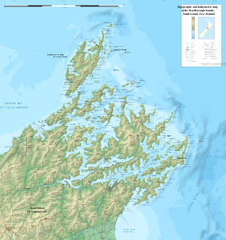
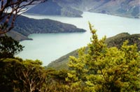
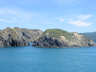
The Marlborough Sounds are an extensive network of sea-drowned valleys at the northern end of the South Island of New Zealand. The Marlborough Sounds were created by a combination of land subsidence and rising sea levels. According to Māori mythology, the sounds are the prows of the many sunken waka of Aoraki.
Port Gore is a bay and natural harbour at the northern end of the Marlborough Sounds in New Zealand. It is close to the northern tip of the South Island, at the western end of Cook Strait. It is directly west of the entrance to Queen Charlotte Sound.
Fairy Bay is east of Mount Stanley, elevation 971 metres (3,186 ft), in Pelorus Sound / Te Hoiere, part of the Marlborough Sounds Maritime Park, at the top of the South Island, New Zealand. The origin of the name is thought to have been the fairy penguin. It has previously been known as Falls River Bay and Sandfly Bay. A neighbouring bay immediately to the south is called Penguin Bay.

Maud Island is one of the larger islands in the Marlborough Sounds on the northeastern tip of the South Island of New Zealand, with a total area of 320 ha.

The Marlborough Province operated as a province of New Zealand from 1 November 1859, when it split away from Nelson Province, until the abolition of provincial government in 1876.

Tōtaranui is a 1 km long beach and the site of a large campsite in the Tasman Region of New Zealand administered by the Department of Conservation (DOC).

Penzance Bay is a popular bay located in Tennyson Inlet, New Zealand, within the Marlborough Sounds. Tennyson Inlet is an arm of Pelorus Sound / Te Hoiere. The bay is immediately north of Tuna Bay, which is accessed by the same road.

The Blenheim Riverside Railway is a 2 ft narrow gauge heritage railway in Blenheim, New Zealand. It runs along the Taylor River, which winds its way through the middle of the town. It is operated by the all-volunteer Blenheim Riverside Railway Society.
West Head is the name of three separate headlands on New Zealand's South Island.
The Opouri River is a river of the Marlborough Region of New Zealand's South Island. It flows generally west from its sources in the Bull Range, a coastal ridge overlooking the Marlborough Sounds, joining with the Rai River 15 kilometres (9 mi) west of Havelock.
The Tunakino River is a river of the Marlborough Region of New Zealand's South Island. It flows south from its origins in a coastal rim of hills at the base of the Marlborough Sounds to reach the Opouri River 5 kilometres (3 mi) east of Rai Valley.
Admiralty Bay is a large indentation in the northern coast of New Zealand's South Island. It lies close to the northernmost mainland point of the Marlborough Sounds, immediately to the south of D'Urville Island.
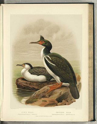
The Marlborough Sounds Important Bird Areas are four distinct sites comprising several small, rocky islets contained within an area with a maximum linear extent of 40 km, in New Zealand. They lie close to Cook Strait in the outer Marlborough Sounds at the northern end of the South Island. The sites are Duffers Reef, Sentinel Rock, White Rocks and the Trio Islands. They have been identified as Important Bird Areas (IBAs) by BirdLife International because they hold the only known colonies, and encompass the entire breeding range, of the vulnerable rough-faced shag.

Fairfield House in 48 Van Diemen Street, Nelson, New Zealand, is registered with Heritage New Zealand as a Category I structure. Originally built in 1849, today's house was constructed as a residence for Arthur Atkinson in 1872. It was at some stage owned by the Nelson College for Girls, who used it as a boarding house. After the 1929 Murchison earthquake, boarders from Nelson College also moved in, as their hostel got damaged. The house was given to Nelson City Council in 1979 and was threatened with demolition. A community group formed that had the objective of saving the house. Alan Stanton moved into the derelict building as a squatter and started restoring it. Today, it is a community centre.
Arrow Rock is a small island in Tasman Bay / Te Tai-o-Aorere, off the coast of Nelson, New Zealand. There is a narrow channel between the rock and Haulashore Island. Situated within Nelson Harbour, Arrow Rock was site of the Fifeshire wreck in 1842, which gave the rock its secondary name. There are a number of spotted shags who live on the rock.
RNZAF Station Waipapakauri was a Royal New Zealand Air Force station located at Waipapakauri, 14 km north of Kaitaia, Northland Region, New Zealand. Originally established in 1933 as a small local aerodrome, it was commandeered as an air force base by the RNZAF at the outbreak of war in 1939.

Tokangawhā / Split Apple Rock is a geological rock formation in Tasman Bay / Te Tai-o-Aorere off the northern coast of the South Island of New Zealand. Made of granite from the cretaceous, it is in the shape of an apple which has been cut in half. The cleft to produce two sides of the 'apple' was a naturally occurring joint. Joints occur commonly in granite and are planes of weakness that rain and waves exploit. The traditional Maori myth for the formation describes two gods breaking apart the rock.
Marlborough District Council is the unitary local authority for the Marlborough District of New Zealand.
Elaine Bay is a bay located in Pelorus Sound / Te Hoiere, within the Marlborough Sounds at the north end of the South Island of New Zealand. Elaine Bay is in the Tawhitinui Reach, which includes other bays such as Tennyson Inlet, Fitzroy Bay and Hallum Cove. The bay is accessed by the Elaine Bay Road, which connects with the Croisilles-French Pass Road at the top of the ridge.
Croisilles Harbour is a natural inlet north of Nelson at the westernmost edge of the Marlborough Sounds on the northern coast of New Zealand's South Island. It has two major arms, Okiwi Bay and Squally Cove.
References
- The New Zealand Guide H. Wise & Co., 1952 pg. 696
41°04′08″S173°56′48″E / 41.06900°S 173.94653°E
| | This Marlborough Region-related geography article is a stub. You can help Wikipedia by expanding it. |