Related Research Articles

Arapaoa Island is the second-largest island in the Marlborough Sounds, at the north-east tip of the South Island of New Zealand. The island has a land area of 75 km2. Queen Charlotte Sound defines its western side, while to the south lies Tory Channel, which is on the sea route between Wellington in the North Island to Picton. Cook Strait's narrowest point is between Arapaoa Island's Perano Head and Cape Terawhiti in the North Island.

Porirua, a city in the Wellington Region of the North Island of New Zealand, is one of the four cities that constitute the Wellington metropolitan area. The name 'Porirua' is a corruption of 'Pari-rua', meaning "the tide sweeping up both reaches". It almost completely surrounds Porirua Harbour at the southern end of the Kāpiti Coast. As of 2023, Porirua has a population of 62,400 people, and is a majority minority city, with 26.5% of its population being primarily Pasifika and 23.0% primarily Māori. Porirua is the only area with city status in New Zealand with a Pasifika plurality.

Palmerston North is a city in the North Island of New Zealand and the seat of the Manawatū-Whanganui region. Located in the eastern Manawatu Plains, the city is near the north bank of the Manawatu River, 35 km (22 mi) from the river's mouth, and 12 km (7 mi) from the end of the Manawatū Gorge, about 140 km (87 mi) north of the capital, Wellington. Palmerston North is the country's eighth-largest urban area, with an urban population of 82,500. The estimated population of Palmerston North city is 91,800.

Taihape is in the Rangitikei District of the North Island of New Zealand. It serves a large rural community. State Highway 1, which runs North to South through the centre of the North Island, passes through the town.

Hanmer Springs is a small town in the Canterbury region of the South Island of New Zealand. The Māori name for Hanmer Springs is Te Whakatakanga o te Ngārahu o te ahi a Tamatea, which means “where the ashes of Tamate’s (sic) fire lay”, referring to Tamatea, the captain of the canoe Tākitimu.

Molesworth Station is a high country cattle station. It is located behind the Inland Kaikōura Mountain range in the South Island's Marlborough District. It is New Zealand's largest farm, at over 1,800 square kilometres and supports the country's biggest herd of cattle. It also hosts government science programs, such as research into bovine tuberculosis and related research into possums. The station helps rabbit population reduction.

Waitaki District is a territorial authority district that is located in the Canterbury and Otago regions of the South Island of New Zealand. It straddles the traditional border between the two regions, the Waitaki River, and its seat is Oamaru.
This is a timeline of environmental history of New Zealand. It includes notable events affecting the natural environment of New Zealand as a result of human activity.

The Clarence River is a major river which flows through the Kaikōura Ranges in the northeast of New Zealand's South Island. At roughly 209 kilometres (130 mi) long, it is the longest river in Canterbury and the eighth longest in New Zealand.

Cass is a small locality in inland Canterbury on New Zealand's South Island, near Arthur's Pass. It is known for its small railway station which was the subject of the 1936 painting Cass by Rita Angus, voted in 2006 New Zealand's favourite work of art. It is also the location of a University of Canterbury field station established in 1914. Cass currently has a single permanent resident.
The following lists events that happened during 1827 in New Zealand.

A station or run, in the context of New Zealand agriculture, is a large farm dedicated to the grazing of sheep and cattle. The use of the word for the farm or farm buildings date back to the mid-nineteenth century. The owner of a station is called a runholder.
The Saxton River is a river in the Marlborough Region of New Zealand's South Island. It flows south from its sources to the east of the Raglan Range, reaching the Acheron River 10 kilometres (6 mi) west of Molesworth Station.
The Tone River is a river of the Marlborough Region of New Zealand's South Island. It flows generally north from its sources in the Inland Kaikoura Range to reach the Awatere River 17 kilometres (11 mi) northeast of Molesworth Station.

The Awatere Fault is an active dextral strike-slip fault in the northeastern part of South Island, New Zealand. It forms part of the Marlborough Fault System, which accommodates the transfer of displacement along the oblique convergent boundary between the Indo-Australian Plate and Pacific Plate, from the transform Alpine Fault to the Hikurangi Trench subduction zone. The 1848 Marlborough earthquake was caused by rupture of the whole of the eastern section of the Awatere Fault.
John Kerr was a 19th-century Member of Parliament from Nelson, New Zealand. As well as Lake Station, Kerr also owned the 70,000 acres (28,000 ha) Tarndale Run and 30,000 acres (12,000 ha) around the Wairau River before entering into a business partnership with Molesworth Station owner Acton Adams. Kerr commissioned cob builder Ned James to build Tarndale homestead in 1874.

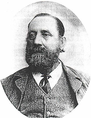
Joseph Ward was a 19th-century Member of Parliament from Marlborough, New Zealand.

New Zealand has a unitary system of government in which the authority of the central government defines sub-national entities. Local government in New Zealand has only the powers conferred upon it by the New Zealand Parliament. Under the Local Government Act 2002, local authorities are responsible for enabling democratic local decision-making and promoting the social, economic, environmental, and cultural well-being of their communities, as well as more specific functions for which they have delegated authority.

Lucy Beatrice Moore was a New Zealand botanist and ecologist.

Lake Tennyson is a glacial high-country lake in Canterbury, New Zealand. The first European settler to see the lake was Frederick Weld in 1853, who also named it. The headwaters of the Waiau Toa / Clarence River are just to the north, and the river flows through Lake Tennyson.
References
- ↑ Orr, Katherine W. "Ward, Joseph". Dictionary of New Zealand Biography . Ministry for Culture and Heritage . Retrieved 19 October 2015.
- ↑ "Wards Pass". Dangerousroads. Retrieved 18 October 2015.
- ↑ Reilly, Helen (2008). Connecting the Country: New Zealand’s National Grid 1886 - 2007. Wellington: Steele Roberts. p. 132. ISBN 978-1-877448-40-9.
| | This Marlborough Region-related geography article is a stub. You can help Wikipedia by expanding it. |