Related Research Articles

Croisilles is a commune in the Calvados department in the Normandy region in northwestern France.
Cabragh House is a late Victorian, timber house at 48 Weka Street in Nelson, New Zealand built circa 1897. It is a historic site for exemplarising late Victorian furnishings and provincial New Zealand vernacular architecture. The neighbouring Amber House, the former site of the Cabragh House School, is pending registration as a New Zealand Historic Place.

The Royal New Zealand Yacht Squadron is a New Zealand yacht club, and the club behind New Zealand's America's Cup campaigns, under the guises of New Zealand Challenge and Team New Zealand. It held the America's Cup from 1995 until 2003, becoming in 2000 the first non-American holder to successfully defend the trophy. After Team New Zealand's victory in the 2017 event, the Royal New Zealand Yacht Squadron are the current holders of the America's Cup. On March 21, 2021, they beat Circolo della Vela Sicilia's Luna Rossa Challenge to again win the 2021 America's Cup.

Penzance Bay is a popular bay located in Tennyson Inlet, New Zealand, within the Marlborough Sounds. Tennyson Inlet is an arm of Pelorus Sound / Te Hoiere. The bay is immediately north of Tuna Bay, which is accessed by the same road.

Whangaroa Harbour, previously spelled Wangaroa Harbour, is an inlet on the northern coast of Northland, New Zealand. Whangaroa Bay and the Pacific Ocean are to the north. The small settlements of Totara North and Saies are on the west side of the harbour, Waitaruke on the south side, and Whangaroa on the east. State Highway 10 runs through Waitaruke. The name comes from the lament "Whaingaroa" or "what a long wait" of a woman whose warrior husband had left for a foray to the south. The harbour was formed when rising sea levels drowned a river valley about 6,000 years ago. Steep outcrops remain from ancient volcanic rocks.
Umawera is a community in Northland, New Zealand. State Highway 1 runs through the community. Mangamuka Bridge is to the northwest, and Rangiahua is to the east. Umawera is part of the Omahuta Forest-Horeke statistical area, which covers the upper Hokianga Harbour. For demographics of this area, see Horeke.
The Kenana River is a river of the North Auckland Peninsula, in New Zealand's North Island. It is located in the north of the peninsula, and flows into Mangonui harbour, an inlet in the south of Doubtless Bay.
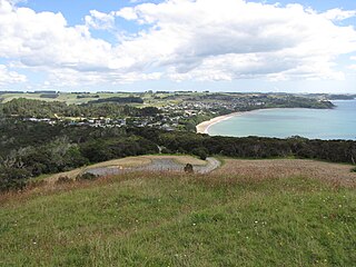
Doubtless Bay is a bay on the east coast of the Northland Region, north-east of Kaitaia, in New Zealand. It extends from Knuckle Point on Karikari Peninsula in the north to Berghan Point at Hihi in the south. There are rocky headlands, backed by many extensive beaches, such as Tokerau Beach, Taipa, Cable Bay, Coopers Beach, and Mangonui Harbour.
Arrow Rock is a small island in Tasman Bay / Te Tai-o-Aorere, off the coast of Nelson, New Zealand. There is a narrow channel between the rock and Haulashore Island. Situated within Nelson Harbour, Arrow Rock was site of the Fifeshire wreck in 1842, which gave the rock its secondary name. There are a number of spotted shags who live on the rock.
Elaine Bay is a bay located in Pelorus Sound / Te Hoiere, within the Marlborough Sounds at the north end of the South Island of New Zealand. Elaine Bay is in the Tawhitinui Reach, which includes other bays such as Tennyson Inlet, Fitzroy Bay and Hallum Cove. The bay is accessed by the Elaine Bay Road, which connects with the Croisilles-French Pass Road at the top of the ridge.
Wakatu is an industrial suburb of Nelson in New Zealand.

Papanui Inlet is the northernmost of two large inlets in the Pacific coast of Otago Peninsula, in the South Island of New Zealand.
Bronte, a locality in the Tasman District of New Zealand, lies between Richmond and Māpua.
Hoopers Inlet is one of two large inlets in the Pacific coast of Otago Peninsula, in the South Island of New Zealand.
Britannia Heights is a major inner suburb of Nelson, New Zealand. It lies on State Highway 6 to the southwest of Nelson city centre, on the shore of Tasman Bay / Te Tai-o-Aorere, between Stepneyville and Tāhunanui.
Tasman Heights is one of the suburbs of Nelson, New Zealand. It lies to the southeast of Nelson city centre, between Wakatu and Moana.

Waimea Inlet is a section of Tasman Bay / Te Tai-o-Aorere, in New Zealand's South Island. It is at the southern end of the bay, and separated from it by the partial barriers of Rabbit Island and Bell Island to the west and Monaco Peninsula and the reclaimed land of Nelson Airport to the east. The southern suburbs of Stoke and the town of Richmond lie close to the shore of Waimea Inlet.
Delaware Bay is an indentation in the New Zealand South Island coast east of Pepin Island, to the north of Nelson. It is part of the larger Tasman Bay / Te Tai-o-Aorere. The bay is named after the Delaware, a newly built brig which sank here on its maiden voyage from Nelson to Napier in 1863, an incident best remembered for the dramatic rescue attempts by a group of local Māori.
Martins Bay is an indentation in the southwest coast of New Zealand's South Island. It lies immediately to the south of Big Bay and some 30 kilometres north of the mouth of Milford Sound at the northern tip of Fiordland. The Hollyford River reaches the Tasman Sea at Martins Bay.

Great Exhibition Bay is a 30-kilometre (19 mi) wide embayment close to the northernmost tip of New Zealand's North Island. It lies on the east coast of the Aupouri Peninsula in the Northland Region. The large natural inlet of Parengarenga Harbour lies at the northern end of the bay.
References
- ↑ Reed, A.W., (1975) Place Names of New Zealand. Wellington: A.H. & A.W. Reed. p.94.
41°03′40″S173°37′50″E / 41.06111°S 173.63056°E
| | This Marlborough Region-related geography article is a stub. You can help Wikipedia by expanding it. |