
Guadalcanal is the principal island in Guadalcanal Province of Solomon Islands, located in the southwestern Pacific Ocean, northeast of Australia. It is the largest island in the Solomons by area and the second-largest by population. The island is mainly covered in dense tropical rainforest and has a mountainous hinterland.

The Auckland Islands are an archipelago of New Zealand, lying 465 km (289 mi) south of the South Island. The main Auckland Island, occupying 460 km2 (180 sq mi), is surrounded by smaller Adams Island, Enderby Island, Disappointment Island, Ewing Island, Rose Island, Dundas Island, and Green Island, with a combined area of 570 km2 (220 sq mi). The islands have no permanent human inhabitants.

Sturge Island is one of the three main islands in the uninhabited Balleny Islands group located in the Southern Ocean. It lies 25 km (16 mi) southeast of Buckle Island and 95 km (59 mi) north-east of Belousov Point on the Antarctic mainland. The island, in Oates Land, also forms part of the Ross Dependency, claimed by New Zealand.

The Manawatāwhi / Three Kings Islands are a group of 13 uninhabited islands about 55 kilometres (34 mi) northwest of Cape Reinga / Te Rerenga Wairua, New Zealand, where the South Pacific Ocean and Tasman Sea converge. They measure 6.85 km2 (2.64 sq mi) in area. The islands are on a submarine plateau, the Three Kings Bank, and are separated from the New Zealand mainland by an 8 km wide, 200 to 300 m deep submarine trough. Therefore, despite relative proximity to the mainland, the islands are listed with the New Zealand Outlying Islands. The islands are an immediate part of New Zealand, but not part of any region or district, but instead Area Outside Territorial Authority, like all the other outlying islands except the Solander Islands.
The Poor Knights Islands are a group of islands off the east coast of the Northland Region of the North Island of New Zealand. They lie 50 kilometres (31 mi) to the northeast of Whangārei, and 22 kilometres (14 mi) offshore halfway between Bream Head and Cape Brett. Uninhabited since the 1820s, they are a nature reserve and popular underwater diving spot, with boat tours typically departing from Tutukaka. The Poor Knights Islands Marine Reserve surrounds the island.
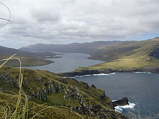
Auckland Island is the main island of the eponymous uninhabited archipelago in the Pacific Ocean. It is part of the New Zealand subantarctic area. It is inscribed in the UNESCO World Heritage list together with the other New Zealand Subantarctic Islands in the region.

The Kermadec Islands are a subtropical island arc in the South Pacific Ocean 800–1,000 km (500–620 mi) northeast of New Zealand's North Island, and a similar distance southwest of Tonga. The islands are part of New Zealand. They are 33.6 km2 (13.0 sq mi) in total area and uninhabited, except for the permanently staffed Raoul Island Station, the northernmost outpost of New Zealand.

The Bounty Islands are a small group of uninhabited granite islets and numerous rocks, with a combined area of circa 50 ha in the South Pacific Ocean. Territorially part of New Zealand, they lie about 670 km (420 mi) east-south-east of New Zealand's South Island, 530 km (330 mi) south-west of the Chatham Islands, and 215 km (134 mi) north of the Antipodes Islands. The group is a World Heritage Site.

Pelorus Sound is the largest of the sounds which make up the Marlborough Sounds at the north of the South Island, New Zealand.

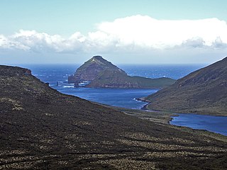
The Antipodes Islands are inhospitable and uninhabited volcanic islands in subantarctic waters to the south of – and territorially part of – New Zealand. The 21 km2 (8.1 sq mi) archipelago lies 860 km (530 mi) to the southeast of Stewart Island/Rakiura, and 730 km (450 mi) to the northeast of Campbell Island. They are very close to being the antipodal point to Normandy in France, meaning that the city farthest away is Cherbourg-en-Cotentin, France.

The Aldermen Islands are a small group of rocky islets to the southeast of Mercury Bay in the North Island of New Zealand. They are located off the coast of the Coromandel Peninsula, 20 kilometres (12 mi) east of the mouth of the Tairua River.

Little Barrier Island, or Hauturu in Māori, lies off the northeastern coast of New Zealand's North Island. Located 80 kilometres (50 mi) to the north of Auckland, the island is separated from the mainland to the west by Jellicoe Channel, and from the larger Great Barrier Island to the east by Cradock Channel. The two aptly named islands shelter the Hauraki Gulf from many of the storms of the Pacific Ocean.

The Hen and Chicken Islands lie to the east of the North Auckland Peninsula off the coast of northern New Zealand. They lie 12 kilometres (7.5 mi) east of Bream Head and 40 kilometres (25 mi) south-east of Whangārei with a total area of 8.44 km2 (3.26 sq mi).
Jacquemart Island, one of the islets surrounding Campbell Island in New Zealand, lies 1 km south of Campbell Island and is the southernmost island of New Zealand.
Welch Island is an island, 1.8 km (1.1 mi) long with a prominent pinnacle rock of 130 m (427 ft), lying north of the Rouse Islands and 2 km (1.2 mi) off the eastern side of Holme Bay in Mac. Robertson Land, Antarctica. It lies 1 km (0.6 mi) south of Welch Rocks.
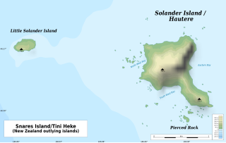
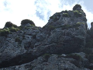
The Solander Islands / Hautere are three uninhabited volcanic islets toward the western end of the Foveaux Strait just beyond New Zealand's South Island. The Māori name Hautere translates into English as "flying wind". The islands lie 38 km (24 mi) south of Prices Point, near where Lake Hakapoua drains through Big River to the ocean due west of Te Waewae Bay, and 64 km (40 mi) northwest of the Putatara (Rugged) Point in the northwest of Stewart Island / Rakiura, or 56 km (35 mi) from Codfish Island / Whenua Hou. The islands measure 1.2 km2 (0.46 sq mi). Administratively, the islands form part of Southland District, making them the only uninhabited outlying island group of New Zealand to be part of a local authority.

The New Zealand outlying islands are nine offshore island groups that are part of New Zealand, with all but Solander Islands lying beyond the 12nm limit of the mainland's territorial waters. Although considered integral parts of New Zealand, seven of the nine island groups are not part of any administrative region or district, but are instead each designated as an Area Outside Territorial Authority. The two exceptions are the Chatham Islands, which are covered by their own special territorial authority, and the Solander Islands, which are part of the Southland Region and Southland District.

The Sugar Loaf Islands are a collection of five small uninhabited islands and several sea stacks near Port Taranaki, New Zealand.
The 1929 Murchison earthquake occurred at 10:17 am on 17 June. It struck the Murchison region of the South Island, with an estimated magnitude of 7.3, and was felt throughout New Zealand. There were 17 deaths, mostly as a result of landslides triggered by the earthquake. The rumbling sound of the earthquake was loud enough to be heard at New Plymouth, more than 250 km (155 mi) away.

Pasifika New Zealanders are a pan-ethnic group of New Zealanders associated with, and descended from, the indigenous peoples of the Pacific Islands outside of New Zealand itself. They form the fourth-largest ethnic grouping in the country, after European descendants, indigenous Māori, and Asian New Zealanders. Over 380,000 people identify as being of Pacific origin, representing 8% of the country's population, with the majority residing in Auckland.


