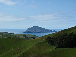
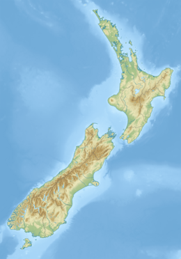
Stephens Island (New Zealand)

Last updated

Stephens Island
Takapourewa ( Māori )
Stephens Island (Takapourewa).jpg
Stephens Island as seen from D'Urville Island
New Zealand (relief map).png
Disc Plain red.svg
Stephens Island
Geography
Location Marlborough Sounds
Coordinates 40°40′S174°00′E / 40.667°S 174.000°E / -40.667; 174.000
Area1.5 km2 (0.58 sq mi)
Highest elevation283 m (928 ft)
Administration
Demographics
Population0

Stephens Island is at the northernmost tip of the Marlborough Sounds in the South Island of New Zealand. It lies two kilometres to the northeast of Cape Stephens, the northernmost point of D'Urville Island. The island is 1.5 square kilometres (0.58 square miles) in size, and rises 283 metres (928 ft) high from the sea. [1]

Contents

Topographic map of Stephens Island Stephens Island.png
Topographic map of Stephens Island

History

The island was owned by the Ngāti Koata iwi but was taken by the government to build a lighthouse in 1891. The Māori called it Takapourewa ("around the tower") [2] [3] but explorer Captain Cook renamed it Stephens Island in 1770 after Sir Philip Stephens, Secretary of the Admiralty. [4] [5]

The island featured in local mythos as the place where a local lighthouse keeper's cat, named Tibbles, was claimed to have caused the extinction of Lyall's wren in 1894. However, this belief was erroneous, [6] an urban legend. While this cat did kill one of the last birds seen, a few more specimens were obtained in the following years, by which time the island also hosted numerous feral cats, and the island was only the last refuge of the bird, which had become extinct on the mainland many centuries earlier due to Polynesian rat predation. [7]

Farming and grazing reduced the island's original vegetation cover by around 90%, before being made a wildlife sanctuary in 1966 and a nature reserve in 1997. In 2012 the Treaty of Waitangi settlement between Ngāti Koata and the New Zealand Government required joint management by Ngāti Koata and the Department of Conservation. [8]

Conservation

Today, the best known resident of Stephens Island is the tuatara. The island is a sanctuary for this rare order of reptile which is now extinct on the mainland, except in tightly controlled reserves including ecological islands.

Stephens Island is internationally important for nature conservation. While most attention has focused on the tuatara, the significant and unique factors include:

Geography

In natural character, Stephens Island is a rugged landmass dominated by maritime influences. Visually the island is connected to the adjacent larger D'Urville Island, and Stephens Island is the largest of the family of islands, islets and rock stacks that characterise this southwestern side of the Cook Strait. Although uninhabited, the island has been extensively modified by land clearance and farming, but retains much of its wild natural character. From sea level the lighthouse is a prominent visual feature, while from the air the cluster of buildings and farmed landscape are obvious.

The surrounding sea is rich with marine life, albeit strongly modified and depleted by fishing, and historically by hunting of whales and seals. The island overlooks one of the great whale migration routes, most notably for humpback whales. Marine mammals such as New Zealand Fur Seals and various dolphin species are seen around the island.

This is an area of strong winds (mean annual wind speed 14 knots or 26 kilometres per hour or 16 miles per hour), strong currents and broken restless seas. The island also harbours strong gradations of weather between the often cloud-covered summit and the wave-lashed shores. There are also distinct differences between the relatively more exposed western and the less exposed eastern shores. Rainfall averages a modest 800 mm (31.5 in).

Geology

Stephens Island is characterised by the Stephens Formation, a geological unit comprising 1100 meters of southeast-dipping sedimentary rocks ranging from mudstone with limestone lenses to volcanogenic sandstone and conglomerate. As the youngest formation within the Maitai Group, these rocks constitute the most northerly exposure of the Nelson Regional Syncline, displaying an overturned orientation on the syncline's eastern limb. Indurated with widespread metamorphic prehnite, pumpellyite, and lawsonite, the formation is subdivided into Queens Beach, Incline, Takapourewa, and Titapua Members, with no discernible top or bottom boundaries. Notably, the oldest rocks, found in the Queens Beach Member, consist of a 150-meter layer of rounded cobble conglomerate enclosing angular blocks of coarse volcanogenic sandstone. Within one such block, measuring 4 meters in length and up to 1.5 meters in thickness, a diverse but moderately preserved marine fossil assemblage dominated by brachiopods and pectinid bivalves of Late Permian age is identified. The contemporaneous formation of the fossiliferous sandstone and conglomerate suggests a Late Permian age, although the potential for a younger (Triassic) age cannot be ruled out. Additionally, Late Quaternary deposits, including loess and windblown sand, are present in localized areas. [9]

Climate

Climate data for Stephens Island (1981–2010)
MonthJanFebMarAprMayJunJulAugSepOctNovDecYear
Mean daily maximum °C (°F)18.8
(65.8)
19.1
(66.4)
18.1
(64.6)
16.0
(60.8)
14.1
(57.4)
12.1
(53.8)
11.2
(52.2)
11.7
(53.1)
12.8
(55.0)
13.9
(57.0)
15.3
(59.5)
17.2
(63.0)
15.0
(59.0)
Daily mean °C (°F)16.0
(60.8)
16.5
(61.7)
15.5
(59.9)
13.7
(56.7)
11.9
(53.4)
10.1
(50.2)
9.2
(48.6)
9.5
(49.1)
10.5
(50.9)
11.4
(52.5)
12.6
(54.7)
14.5
(58.1)
12.6
(54.7)
Mean daily minimum °C (°F)13.3
(55.9)
13.8
(56.8)
12.9
(55.2)
11.4
(52.5)
9.8
(49.6)
8.1
(46.6)
7.1
(44.8)
7.3
(45.1)
8.1
(46.6)
9.0
(48.2)
10.0
(50.0)
11.8
(53.2)
10.2
(50.4)
Average rainfall mm (inches)61
(2.4)
39
(1.5)
63
(2.5)
67
(2.6)
81
(3.2)
74
(2.9)
86
(3.4)
79
(3.1)
65
(2.6)
71
(2.8)
62
(2.4)
61
(2.4)
809
(31.8)
Source: NIWA (rain 1961–1990) [10]

See also

Related Research Articles

<span class="mw-page-title-main">Tuatara</span> Species of reptile

The tuatara is a species of reptile endemic to New Zealand. Despite its close resemblance to lizards, it is part of a distinct lineage, the order Rhynchocephalia. The name tuatara is derived from the Māori language and means "peaks on the back".

<span class="mw-page-title-main">D'Urville Island</span> Landmass off South Island in the South Pacific

D'Urville Island, Māori name Rangitoto ki te Tonga, is the largest island in the Marlborough Sounds, on the northern coast of the South Island of New Zealand. It was named after the French explorer Jules Dumont d'Urville. With an area of approximately 150 square kilometres (58 sq mi), it is the eighth-largest island of New Zealand, and has around 52 permanent residents. The local authority is the Marlborough District Council.

<span class="mw-page-title-main">Auckland Islands</span> Volcanic archipelago in New Zealand

The Auckland Islands are an archipelago of New Zealand, lying 465 km (289 mi) south of the South Island. The main Auckland Island, occupying 460 km2 (180 sq mi), is surrounded by smaller Adams Island, Enderby Island, Disappointment Island, Ewing Island, Rose Island, Dundas Island, and Green Island, with a combined area of 570 km2 (220 sq mi). The islands have no permanent human inhabitants.

<span class="mw-page-title-main">New Zealand storm petrel</span> Species of bird

The New Zealand storm petrel is a small seabird of the family Oceanitidae endemic to New Zealand. Thought to be extinct since 1850, a series of sightings from 2003 to the present indicated the presence of a previously unknown colony. The population of New Zealand storm petrels has been estimated to be less than 2000.

<span class="mw-page-title-main">Auckland Island</span> Island off Southern New Zealand

Auckland Island is the main island of the eponymous uninhabited archipelago in the Pacific Ocean. It is part of the New Zealand subantarctic area. It is inscribed in the UNESCO World Heritage list together with the other New Zealand Subantarctic Islands in the region.

<span class="mw-page-title-main">Fauna of New Zealand</span> Animal species of New Zealand

The animals of New Zealand, part of its biota, have an unusual history because, before the arrival of humans, less than 900 years ago, the country was mostly free of mammals, except those that could swim there or fly there (bats). However, as recently as the Miocene, it was home to the terrestrial Saint Bathans mammal, implying that mammals had been present since the island had broken away from other landmasses. The absence of mammals meant that all of the ecological niches occupied by mammals elsewhere were occupied instead by either insects or birds, leading to an unusually large number of flightless birds, including the kiwi, the weka, the moa, the takahē, and the kākāpō.

<span class="mw-page-title-main">Lyall's wren</span> Extinct species of bird

Lyall's wren or the Stephens Island wren was a small, flightless passerine belonging to the family Acanthisittidae, the New Zealand wrens. Now extinct, it was once found throughout New Zealand, but when it came to the attention of scientists in 1894, its last refuge was Stephens Island in Cook Strait. Often claimed to be a species driven extinct by a single creature, the wren in fact fell victim to the island's numerous feral cats. The wren was described almost simultaneously by both Walter Rothschild and Walter Buller. It became extinct shortly thereafter.

<span class="mw-page-title-main">Moutohora Island</span> Island in the Bay of Plenty, New Zealand

Moutohora Island is a small uninhabited island located off the Bay of Plenty coast of New Zealand's North Island, about 9 kilometres (5.6 mi) north of the town of Whakatāne. The 1.43 km2 (0.55 sq mi) island is a remnant of a complex volcano which has eroded, leaving two peaks. This is still an area of volcanic activity and there are hot springs on the island in Sulphur Valley, McEwans Bay, and Sulphur Bay.

<span class="mw-page-title-main">Little Barrier Island</span> Island in the Hauraki Gulf, New Zealand

Little Barrier Island, or Hauturu in Māori, lies off the northeastern coast of New Zealand's North Island. Located 80 kilometres (50 mi) to the north of Auckland, the island is separated from the mainland to the west by Jellicoe Channel, and from the larger Great Barrier Island to the east by Cradock Channel. The two aptly named islands shelter the Hauraki Gulf from many of the storms of the Pacific Ocean.

<span class="mw-page-title-main">Mana Island (New Zealand)</span> Island in New Zealand

Mana Island is the smaller of two islands that lie off the southwest coast of the North Island of New Zealand. The name of the Island is an abbreviation of the Maori name Te Mana o Kupe, which means "The Mana of Kupe".

<span class="mw-page-title-main">Laughing owl</span> Extinct species of owl

The laughing owl, also known as whēkau, the jackass, or the white-faced owl, is an extinct species of owl that was endemic to New Zealand. Plentiful when European settlers arrived in New Zealand, its scientific description was published in 1845, but it was largely or completely extinct by 1914. The species was traditionally considered to belong to the monotypic genus Sceloglaux Kaup, 1848, although recent genetic studies indicate that it belongs with the boobook owls in the genus Ninox.

<span class="mw-page-title-main">Solander Islands</span> Three islets off the South Island of New Zealand

The Solander Islands / Hautere are three eroded remnants volcanic islets towards the western enterance of the Foveaux Strait just beyond New Zealand's South Island. The islands lie 40 km (25 mi) south of the coastline of Fiordland.

<span class="mw-page-title-main">Grey-faced petrel</span> Species of bird

The grey-faced petrel is a species of petrel endemic to the North Island of New Zealand. In New Zealand it is also known by its Māori name ōi and as a muttonbird.

<span class="mw-page-title-main">Tasman Island</span> Island in Tasmania, Australia

The Tasman Island, part of the Tasman Island Group, is an oval island with an area of 1.2 square kilometres (0.46 sq mi), lying close to the south-eastern coast of Tasmania, Australia. The island is located in the Tasman Sea, situated off the Tasman Peninsula and is contained within the Tasman National Park.

<span class="mw-page-title-main">French Pass</span> Narrow and treacherous stretch of water on the west of New Zealand

French Pass is a narrow and treacherous stretch of water that separates D'Urville Island, at the north end of the South Island of New Zealand, from the mainland coast. At one end is Tasman Bay, and at the other end the outer Pelorus Sound / Te Hoiere leads out to Cook Strait.

Haimona Patete was a New Zealand Māori leader and religious founder. Of Māori descent, he identified with the Ngati Koata and Ngati Kuia iwi. He was born on D'Urville Island, Marlborough, New Zealand in about 1863. He founded a religion based in part upon the teachings of Paora Te Potangaroa

John Te One Hippolite was a New Zealand farm labourer, political activist, nurse. Of Māori descent, he identified with the Ngāti Koata, Ngāti Kuia and Ngāti Toa iwi. He was born in D'Urville Island, Marlborough, New Zealand on 25 August 1929.

<span class="mw-page-title-main">Stephens Island Lighthouse</span> Lighthouse

The Stephens Island / Takapourewa lighthouse is one of New Zealand most powerful lights with a range of 18 nautical miles. Perched 183 metres (600 ft) up, on top of Stephens Island, it guards Cook Strait and Tasman Bay / Te Tai-o-Aorere, at the top of the South Island / Te Wai Pounamu.The light flashes white once every six seconds from a white cast iron tower.

The Wharepapa / Arthur Range is a mountain range partially marking the boundary between the Tasman District and West Coast Region of New Zealand's South Island. The range is at the eastern extent of the Tasman Mountains which make up much of the island's northwest, making it easily visible from across the low-lying Waimea Plains further to the east. The range's location and its many uses make it a significant site for local Māori, including the iwi of Te Ātiawa and Ngāti Rārua. This includes the prominent peaks of Mount Arthur and Pukeone / Mount Campbell, which both hold mana in their own right and have become part of the identity of the aforementioned iwi.

Motunau / Plate Island is a small island in the Bay of Plenty, roughly 12 kilometres (7.5 mi) off New Zealand's North Island at Okurei Point and a similar distance east-south-east from the much larger Mōtītī Island. The island is split into northern and southern portions by a small channel as narrow as 2 metres across, with several small sea stacks surrounding the two main parts of the island. Like many of the other islands in the Bay of Plenty, Motunau is volcanic in origin and lacks any permanent fresh water source, and as a result has not seen permanent settlement by humans.

References

  1. K. Thalia East, Michael R. East and Charles H. Daugherty (1995), "Ecological restoration and habitat relationships of reptiles on Stephens Island, New Zealand" (PDF), New Zealand Journal of Zoology, 22 (3): 250, doi:10.1080/03014223.1995.9518040
  2. Ryan, P. M. (29 June 2009). The Raupo Pocket Dictionary of Modern Maori. Penguin Random House New Zealand Limited. ISBN   9781742288840 via Google Books.
  3. "taka - Māori Dictionary". maoridictionary.co.nz.
  4. Patete, Anthony (1996). "Patete, Haimona". Te Ara – the Encyclopedia of New Zealand. Retrieved 15 March 2018.
  5. Ure, Graham (October 1996). "Island Refuge". New Zealand Geographic. Retrieved 15 March 2018.
  6. Medway, D.G. (2004) The land bird fauna of Stephens Island, New Zealand in the early 1890s, and the cause of its demise. Notornis, 51:201–211.
  7. Galbreath, R.; D. Brown (2004). "The tale of the lighthouse-keeper's cat: discovery and extinction of the Stephens Island wren (Traversia lyalli)" (PDF). Notornis. 51 (4): 193–200.
  8. Salvador, Rodrigo B.; Birmingham, Chris; Kilduff, Linda; Bliss, Tansy; Green, Chris J. (1 January 2020). "First records of the exotic garlic snail Oxychilus alliarius on Takapourewa and a reassessment of its distribution in New Zealand". Tuhinga: Records of the Museum of New Zealand Te Papa Tongarewa. 31: 120–128.
  9. H. J. Campbell , A. C. Coleman , M. R. Johnston & C. A. Landis (1984) Geology of Stephens Island and the age of Stephens formation, New Zealand Journal of Geology and Geophysics, 27:3, 277–289, DOI: 10.1080/00288306.1984.10422297
  10. "CliFlo – National Climate Database : Stephens Island". NIWA. Retrieved 20 May 2024.

Further reading

40°40′S174°00′E / 40.667°S 174.000°E / -40.667; 174.000