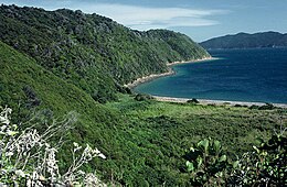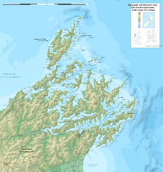
The Marlborough Sounds are an extensive network of sea-drowned valleys at the northern end of the South Island of New Zealand. The Marlborough Sounds were created by a combination of land subsidence and rising sea levels. According to Māori mythology, the sounds are the prows of the many sunken waka of Aoraki.

Fiordland is a geographical region of New Zealand in the south-western corner of the South Island, comprising the westernmost third of Southland. Most of Fiordland is dominated by the steep sides of the snow-capped Southern Alps, deep lakes, and its steep, glacier-carved and now ocean-flooded western valleys. The name "Fiordland" comes from a variant spelling of the Scandinavian word for this type of steep valley, "fjord". The area of Fiordland is dominated by, and very roughly coterminous with, Fiordland National Park, New Zealand's largest National Park.

Kaikōura is a town on the east coast of the South Island of New Zealand. It is located on State Highway 1, 180 km north of Christchurch. The town has an estimated permanent resident population of 2,360.

The Prince Edward Islands are two small uninhabited islands in the sub-Antarctic Indian Ocean that are part of South Africa which are named Marion Island and Prince Edward Island.
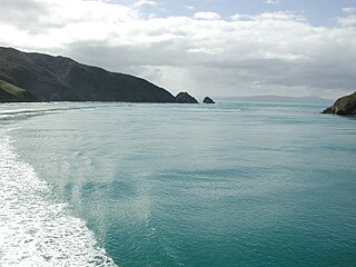
Tory Channel is one of the drowned valleys that form the Marlborough Sounds in New Zealand. Inter-island ferries normally use it as the principal channel between Cook Strait and the Marlborough Sounds.

Farewell Spit is a narrow sand spit at the northern end of the Golden Bay, in the South Island of New Zealand. The spit includes around 25 km (16 mi) of stable land and another 5 km (3.1 mi) of mobile sand spit running eastwards from Cape Farewell, the northern-most point of the South Island. Farewell Spit is the longest sand spit in New Zealand, and is a legally protected Nature Reserve. The area is designated as a Ramsar wetland site and an East Asian–Australasian Flyway Shorebird Network site. Farewell Spit is administered by the New Zealand Department of Conservation as a seabird and wildlife reserve. Apart from a small area at the base of the spit, it is closed to the public except through organised tours. Conservation initiatives are in progress towards eliminating mammalian predators from Farewell Spit, including a proposal for a predator-proof fence.

Stephens Island is at the northernmost tip of the Marlborough Sounds in the South Island of New Zealand. It lies two kilometres to the northeast of Cape Stephens, the northernmost point of D'Urville Island. The island is 1.5 square kilometres in size, and rises 283 metres (928 ft) high from the sea.

Resolution Island or Tau Moana (Māori) is the largest island in the Fiordland region of southwest New Zealand, covering a total of 208 km2 (80 sq mi). It is the country's seventh largest island, and the second largest uninhabited island. Resolution Island is separated from the mainland of the South Island by Tamatea / Dusky Sound, Te Puaitaha / Breaksea Sound, and Acheron Passage. The island is part of the Fiordland National Park.

The Brothers is a group of small islands in Cook Strait, New Zealand, off the east coast of Cape Koamaru, Arapaoa Island. The islands are a restricted-access wildlife sanctuary administered by the Department of Conservation.

Pelorus Sound is the largest of the sounds which make up the Marlborough Sounds at the north of the South Island, New Zealand.
Kenepuru Sound is one of the larger of the Marlborough Sounds in the South Island of New Zealand. The drowned valley is an arm of Pelorus Sound / Te Hoiere, it runs for 25 kilometres (16 mi) from the northeast to southwest, joining Pelorus Sound a quarter of the way down the latter's path to the Cook Strait.

Mana Island is the smaller of two islands that lie off the southwest coast of the North Island of New Zealand. The name of the Island is an abbreviation of the Maori name Te Mana o Kupe, which means "The Mana of Kupe".

Maud Island is one of the larger islands in the Marlborough Sounds on the northeastern tip of the South Island of New Zealand, with a total area of 320 ha.

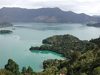
Blumine Island / Ōruawairua is an island in the outer reaches of Queen Charlotte Sound / Tōtaranui, in the Marlborough Sounds at the northern end of New Zealand's South Island.

Meretoto / Ship Cove is a small bay in the Marlborough Region of New Zealand, renowned as the first place of prolonged contact between Māori and Europeans. It is located near the entrance of Queen Charlotte Sound / Tōtaranui, west of nearby Motuara Island and Long Island.
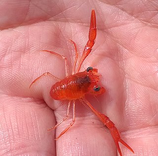
Munida gregaria, commonly known as the gregarious squat lobster, is a species of squat lobster found along the eastern seaboard of the South Island of New Zealand, around the southern coast of Tasmania and in a few locations around the southern parts of South America and Tierra del Fuego.

Motuara Island is a scenic and historical reserve that lies at the entrance to Queen Charlotte Sound / Tōtaranui. It is notable for the actions of James Cook. During HMS Endeavour's stay at nearby Meretoto / Ship Cove, Cook climbed to the summit of Motuara, and formally claimed it and the adjacent lands in the name of and for the use of the sovereign of the British Empire.

Ward Beach is a section of rugged coastline in the Marlborough Region of New Zealand that is known for unusual rock formations. The geological features include the exposed reef platforms that were uplifted by 2 m or more during the 2016 Kaikōura earthquake, and the spherical concretions known as the Ward Beach boulders. Another formation known as the Chancet Rocks is located in a scientific reserve about 1.5 km to the north of the Ward Beach roadend. They contain unusual trace fossils and provide amongst the best on-land evidence of the Cretaceous–Paleogene boundary in marine sediments in the Southern Hemisphere.
Long Island-Kokomohua Marine Reserve is a marine reserve, in the Marlborough Region of New Zealand's South Island. It covers an area of 619 hectares at the entrance to the Queen Charlotte Sound in the Marlborough Sounds. It was the first marine reserve established on the South Island.

Wharariki Ecosanctuary is a wildlife sanctuary within a predator-proof fence at Cape Farewell, New Zealand.