
Arapaoa Island is the second-largest island in the Marlborough Sounds, at the north-east tip of the South Island of New Zealand. The island has a land area of 75 km2. Queen Charlotte Sound defines its western side, while to the south lies Tory Channel, which is on the sea route between Wellington in the North Island to Picton. Cook Strait's narrowest point is between Arapaoa Island's Perano Head and Cape Terawhiti in the North Island.
Transport in New Zealand has always faced many challenges, given the country's mountainous topography and a relatively small population, which is located mostly near its long coastline. Before Europeans arrived, Māori either walked or used watercraft on rivers and along the coasts. European shipping and railways revolutionised the transport of goods and people, before themselves being overtaken by road and air transport, which are now the dominant forms. Bulk freight still continues to be transported by coastal shipping and by rail, and there are attempts to (re)introduce public transport as a major transport mode in the larger population centres.

Cook Strait is a strait that separates the North and South Islands of New Zealand. The strait connects the Tasman Sea on the northwest with the South Pacific Ocean on the southeast. It is 22 kilometres (14 mi) wide at its narrowest point, and is considered one of the most dangerous and unpredictable waters in the world. Regular ferry services run across the strait between Picton in the Marlborough Sounds and Wellington.
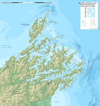
The Marlborough Sounds are an extensive network of sea-drowned valleys at the northern end of the South Island of New Zealand. The Marlborough Sounds were created by a combination of land subsidence and rising sea levels. According to Māori mythology, the sounds are the prows of the many sunken waka of Aoraki.

Marlborough District or the Marlborough Region, commonly known simply as Marlborough, is one of the 16 regions of New Zealand, located on the northeast of the South Island. Marlborough is a unitary authority, both a district and a region. Marlborough District Council is based at Blenheim, the largest town. The unitary region has a population of 52,300.
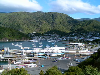
Picton is a town in the Marlborough Region of New Zealand's South Island. The town is located near the head of the Queen Charlotte Sound / Tōtaranui, 25 km (16 mi) north of Blenheim and 65 km (40 mi) west of Wellington. Waikawa lies just north-east of Picton and is considered to be a contiguous part of the Picton urban area.
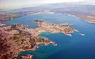
Wellington Harbour, officially called Wellington Harbour / Port Nicholson, is a large natural harbour on the southern tip of New Zealand's North Island. The harbour entrance is from Cook Strait. Central Wellington is located on parts of the western and southern sides of the harbour, and the suburban area of Lower Hutt is to the north and east.
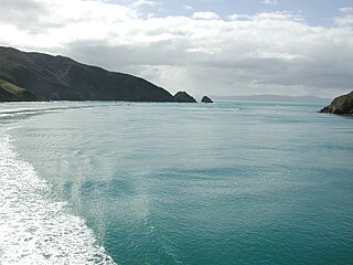
Tory Channel is one of the drowned valleys that form the Marlborough Sounds in New Zealand. Inter-island ferries normally use it as the principal channel between Cook Strait and the Marlborough Sounds.
The HVDC Inter-Island link is a 610 km (380 mi) long, 1200 MW high-voltage direct current (HVDC) transmission system connecting the electricity networks of the North Island and South Island of New Zealand together. It is commonly referred to as the Cook Strait cable in the media and in press releases, although the link is much longer than its Cook Strait section. The link is owned and operated by state-owned transmission company Transpower New Zealand.

Queen Charlotte Sound / Tōtaranui is the easternmost of the main sounds of the Marlborough Sounds, in New Zealand's South Island.

Te Koko-o-Kupe / Cloudy Bay is located at the northeast of New Zealand's South Island, to the south of the Marlborough Sounds and north of Clifford Bay. In August 2014, the name Cloudy Bay, given by Captain Cook in 1770, was officially altered to Te Koko-o-Kupe / Cloudy Bay, with the Māori name recalling the early explorer Kupe scooping up oysters from the bay. The area lends its name to one of the best known New World white wines although the grapes used in production of that wine are grown in the Marlborough wine region further inland.
The cluster of rocks that is Barrett Reef is one of the most hazardous reefs in New Zealand.
StraitNZ, formerly Strait Shipping and Bluebridge, is a New Zealand transport firm that operates roll-on/roll-off freight and passenger shipping across the Cook Strait, between Wellington in the North Island and Picton in the South Island, as well as trucking and logistics services across New Zealand.

Interislander is a road and rail ferry service across New Zealand's Cook Strait, between Wellington in the North Island and Picton in the South Island. It is owned and operated by state-owned rail operator KiwiRail. Three roll-on roll-off (RORO) vessels operate the 50-nautical-mile route, taking about three hours to complete the crossing.

HSC INCAT 046 was a wave-piercing catamaran passenger-vehicle ferry. It operated under various marketing names, including Devil Cat, The Cat, The Lynx, and lastly The T&T Express.
The Lynx Express was a long-distance passenger train in the South Island of New Zealand that ran the length of the Main North Line between Picton and Christchurch. The service was operated by New Zealand Rail Limited business unit InterCity Rail.

MS Kaiarahi is a roll-on/roll-off ferry operated by Interislander on the Wellington to Picton interisland route between the North and South islands of New Zealand.

Matapara / Pickersgill Island is an island in New Zealand's Marlborough Sounds, in the outer reaches of Queen Charlotte Sound / Tōtaranui. The island is separated from Cook Strait by nearby Arapaoa Island, however this offers little protection for Matapara from the prevailing northerly wind.

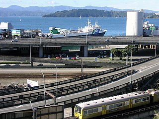
CentrePort Wellington (CentrePort) provides land and sea infrastructure and manages port facilities in Wellington Harbour in New Zealand. The company is the successor to the Wellington Harbour Board, and was formed as one of the outcomes of the 1989 local government reforms. This article is about both the company and the port.

The Classic New Zealand Wine Trail is a 380-kilometre (240 mi) tourist road route in New Zealand that covers both the Hawke's Bay and Wairarapa regions of the North Island, as well as the Marlborough District of the South Island, connected by the Cook Strait ferry crossing. The route traverses the principal New Zealand wine regions of Hawke's Bay, Wairarapa, and Marlborough, which together represent about 80 percent of the country's total production.


