
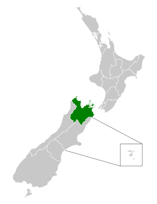
Marlborough District or the Marlborough Region, commonly known simply as Marlborough, is one of the 16 regions of New Zealand, located on the northeast of the South Island. Marlborough is a unitary authority, both a district and a region. Marlborough District Council is based at Blenheim, the largest town. The unitary region has a population of 52,200.

Havelock is a small town in the Marlborough Region of New Zealand, at the head of Pelorus Sound, one of the Marlborough Sounds, and at the mouth of the Pelorus and Kaituna Rivers

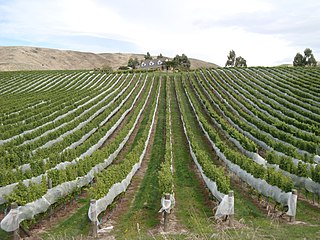
Blenheim is the most populous town in the region of Marlborough, in the north east of the South Island of New Zealand. It has an estimated urban population of 30,500. The surrounding Marlborough wine region is well known as the centre of the New Zealand wine industry. It enjoys one of New Zealand's sunniest climates, with warm, relatively dry summers and cool, crisp winters.

Renwick is a small town in Marlborough, New Zealand, close to the south bank of the Wairau River. It is located on State Highway 6, 12 kilometres (7 mi) west of Blenheim. Havelock is 31 km (19 mi) north. State Highway 63 runs southwest from Renwick through the Wairau River valley.

Seddon is a small town in Marlborough, New Zealand. It is located 25 kilometres (16 mi) south of Blenheim, close to the mouths of the Awatere and Blind Rivers and the Lake Grassmere salt works.

Ward is a small town in Marlborough, New Zealand. It is located on State Highway 1, 82 kilometres (51 mi) north of Kaikōura. The Flaxbourne River flows past to the north and into the Pacific Ocean at Ward Beach to the south-east of Ward. A current initiative aims to have the town renamed as Flaxbourne.

Rapaura is a locality northwest of Blenheim, New Zealand. The Wairau River flows past to the north. Spring Creek lies to the east.

Waikawa is a small settlement to the north east of Picton, Marlborough, New Zealand. Waikawa Bay opens onto Queen Charlotte Sound.

Rai Valley is a rural settlement in Marlborough, New Zealand. It is located on State Highway 6, 68 km (42 mi) northwest of Blenheim and 46 km (29 mi) east of Nelson. The Rai River runs past the locality to join the Pelorus River at the locality of Pelorus Bridge to the south. At the 2018 census, the settlement had a population of 177.

Wairau Valley is the valley of the Wairau River in Marlborough, New Zealand and also the name of the main settlement in the upper valley. State Highway 63 runs through the valley. The valley opens onto the Wairau Plain, where Renwick and Blenheim are sited. The Alpine–Wairau Fault runs along the length of the valley.

Tuamarina is a small town in Marlborough, New Zealand. State Highway 1 runs through the area. The Tuamarina River joins the Wairau River just south of the settlement. Picton is about 18 km to the north, and Blenheim is about 10 km to the south.

Spring Creek is a small town in Marlborough, New Zealand. State Highway 1 runs past the settlement to the west, and the Wairau River flows past to the east. Picton is 22 km to the north, and Blenheim is 6 km to the south.
Grovetown is a small town in Marlborough, New Zealand. State Highway 1 runs past the settlement to the west, and the Wairau River flows past to the northeast. Spring Creek is about 2.5 km to the north, and Blenheim is about 3.5 km to the south. To the east is Grovetown Lagoon, an oxbow loop of the Wairau River. The settlement had a usual resident population of 357 at the 2018 New Zealand census.

Riverlands is a locality in Marlborough, New Zealand. State Highway 1 runs through the settlement, and the Ōpaoa River flows past to the northeast. Blenheim is about 2.5 km to the northwest.
Fairhall is a locality in Marlborough, New Zealand. Blenheim is about 7.5 km to the northeast. The Fairhall River runs past to the west.

Mayfield is a suburb to the north of Blenheim's central district, in the Marlborough region of the South Island of New Zealand. Pollard Park and Lansdowne Park are large parks to the west and north of the suburb, and a racecourse lies to the northwest.
Redwoodtown is a suburb to the south of Blenheim's central business district.

Springlands is a suburb to the west of Blenheim's central district. It is located on and around SH 6, the main road to Renwick. It has a tavern, various takeaways, and a superstore.
The Nelson Marlborough District Health Board was a district health board with the focus on providing healthcare to the Nelson, Tasman and Marlborough districts of New Zealand. In July 2022, it was merged into the national health service Te Whatu Ora.

Blenheim Central is the central suburb and central business district of Blenheim, in the Marlborough region of the South Island of New Zealand. The central park, Seymour Square, contains a clock tower and war memorial fountain.
