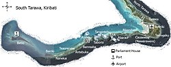
Betio is the name of both an island and a township within the Tarawa Atoll, part of the Republic of Kiribati. Betio is the largest township of Kiribati's capital city, South Tarawa, and it is also the country's primary port. Betio is located at the far southwest corner of the atoll. The island is known for its historical significance during the Battle of Tarawa in World War 2.
Japanese forces attacked the island in December 1941 and occupied it the following year. Allied nationals, including seafarers and civil servants were taken prisoner and who housed on the island. Several escaped in a small open launch boat, towing a lifeboat.[1] They sailed to Nonouti, in the Southern Gilberts, where they were met by the Degei, commanded by Captain G. J. (Jack) Webster in which they returned from Nonouti to Fiji.
Following a US air raid on the island, POWs were massacred in retaliation, by Japanese guards: there was a mass beheading of New Zealand military and civilian coastwatchers.[2][3] News of the massacre was suppressed by Allied authorities at the time to the extent that New Zealand and Fijian governments did not inform the families of the men killed. Despite this, rumours reportedly circulated in New Zealand; these may have influenced the Featherstone incident (25 February 1943), when guards at a POW camp in New Zealand fired on Japanese prisoners,[4][5] killing 48 and wounding 74. However, the immediate cause of the incident was the POWs' refusal to work (as permitted by the Geneva Convention).
The island was liberated by US forces in the Battle of Tarawa, in November 1943.[4] Relics of the Japanese invasion, and the subsequent American assault on the islet in 1943, remain there. After the battle the airstrip was renamed Hawkins Field.
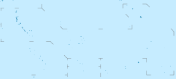
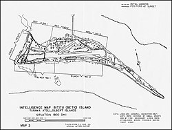
Guns left over from World War IIMap of Betio from World War II.
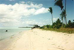
Many signs of the Japanese occupation, battle and subsequent US bases have remained. The site of the former airstrip can be seen in the stunted growth of palms along its length. Many bunkers remain, as well as the remains of military equipment.The partly submerged hulk of a ship, either the Japanese freighter Saidu Maru, or the British steamer Nimanoa, would later be used as a machine gun post by the Japanese against the US forces that re-took Tarawa.[1] Unexploded artillery shells, mortar rounds, anti-aircraft shells and live machine gun bullets left over from the Second World War are littered throughout the island and surrounding reef, as well as the remains of several hundred U.S. and Japanese soldiers. The remains of 30 U.S. soldiers and Marines were discovered in March 2019.[6] following investigative work by History Flight, an American nonprofit which focuses on the repatriation of the remains of US military personnel who have been labeled missing in action.
Post-War History
Japanese-built causeway between Betio and Bairiki islands
A causeway to Bairiki was constructed in the early 1980s, leading to an increase in human contact with the island. Due to changing currents resulting from the construction of the causeway, Bikeman Island, northeast of Betio, has been submerged since the early 1990s.
References
12"Scuttled Ship "Niminoa"". Archived from the original on 30 August 2009.". Tarawa on the Web: The Assault of the Second Marine Division on Betio Island, Tarawa Atoll, 20–23 November 1943.
↑Source: Australian National Archives; Report on Japanese atrocities at Tarawa, Gilbert and Ellice Islands (execution of European prisoners at Betio, Tarawa on or about 15 October 1942), compiled by Major DCI Wernham, District Officer, Gilbert Islands, supplied to Australian government by High Commissioner for the Western Pacific, February 1944.
↑Premier Postal History. "Post Office List". Premier Postal Auctions. Retrieved 5 July 2013.
This page is based on this Wikipedia article Text is available under the CC BY-SA 4.0 license; additional terms may apply. Images, videos and audio are available under their respective licenses.