
The Atlantic Ocean is the second-largest of the world's five oceans, with an area of about 106,460,000 km2 (41,100,000 sq mi). It covers approximately 20% of Earth's surface and about 29% of its water surface area. It is known to separate the "Old World" of Africa, Europe and Asia from the "New World" of the Americas in the European perception of the World.

Kiribati, officially the Republic of Kiribati, is an independent island nation in the central Pacific Ocean. The permanent population is over 119,000 (2020), more than half of whom live on Tarawa atoll. The state comprises 32 atolls and one raised coral island, Banaba. There is a total land area of 811 square kilometres dispersed over 3.5 million km2 (1.4 million sq mi) of ocean.

Kiribati consists of 32 atolls and one island scattered over all four hemispheres in an expanse of ocean equivalent in size to the contiguous United States. The islands lie roughly halfway between Hawaii and Australia in the Micronesian and Polynesian regions of the South Pacific. The three main island groupings are the Gilbert Islands, Phoenix Islands, and Line Islands. On 1 January 1995 Kiribati moved the International Date Line to include its easternmost islands and make it the same day throughout the country.

The Pacific Ocean is the largest and deepest of Earth's five oceanic divisions. It extends from the Arctic Ocean in the north to the Southern Ocean in the south and is bounded by the continents of Asia and Australia in the west and the Americas in the east.

USS Pampanito (SS-383/AGSS-383), a Balao-class submarine, was a United States Navy ship, the third one named for the pompano fish. She completed six war patrols from 1944 to 1945 and served as a Naval Reserve Training ship from 1960 to 1971. She is now a National Historic Landmark, preserved as a memorial and museum ship in the San Francisco Maritime National Park Association located at Fisherman's Wharf.

The Battle of Tarawa was fought on 20–23 November 1943 between the United States and Japan at the Tarawa Atoll in the Gilbert Islands, and was part of Operation Galvanic, the U.S. invasion of the Gilberts. Nearly 6,400 Japanese, Koreans, and Americans died in the fighting, mostly on and around the small island of Betio, in the extreme southwest of Tarawa Atoll.

Tarawa is an atoll and the capital of the Republic of Kiribati, in the central Pacific Ocean. It comprises North Tarawa, which has 6,629 inhabitants and much in common with other more remote islands of the Gilberts group, and South Tarawa, which has 56,388 inhabitants as of 2015, half of the country's total population. The atoll was the site of the Battle of Tarawa during World War II.

South Tarawa is the capital and hub of the Republic of Kiribati and home to more than half of Kiribati's population. The South Tarawa population centre consists of all the small islets from Betio in the west to Bonriki and Tanaea in the north-east, connected by the South Tarawa main road, with a population of 63,439 as of 2020.

Betio is the largest township of Kiribati's capital city, South Tarawa, and the country's main port. The settlement is located on a separate islet at the extreme southwest of the atoll.

USS Ringgold (DD-500), a Fletcher-class destroyer, was the second ship of the United States Navy to be named for Rear Admiral Cadwalader Ringgold (1802–1867). Entering service in 1942 during World War II, the destroyer served in the Pacific theater. Following the war the ship was placed in reserve before being transferred to the West German Navy and renamed Zerstörer 2 in 1959. In 1981 the destroyer was transferred to the Hellenic Navy and was renamed Kimon. Kimon was sold for scrap in 1993.
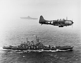
The Gilbert and Marshall Islands campaign were a series of battles fought from November 1943 through February 1944, in the Pacific theatre of World War II between the United States and Japan. They were the first steps of the drive across the central Pacific by the United States Pacific Fleet and Marine Corps. The purpose was to establish airfields and naval bases that would allow air and naval support for upcoming operations across the Central Pacific. Operation Galvanic and Operation Kourbash were the code names for the Gilberts campaign that included the seizures of Tarawa and Makin, during the Battle of Tarawa of 20–23 November and the Battle of Makin of 20–24 November 1943. Operation Flintlock and Operation Catchpole were aimed at capturing Japanese bases at Kwajalein, Eniwetok, and Majuro in the Marshall Islands.

The Pacific Remote Islands Marine National Monument is a group of unorganized, mostly unincorporated United States Pacific Island territories managed by the United States Fish and Wildlife Service of the United States Department of the Interior and the National Oceanic and Atmospheric Administration (NOAA) of the United States Department of Commerce. These remote refuges are "the most widespread collection of marine- and terrestrial-life protected areas on the planet under a single country's jurisdiction". They protect many endemic species including corals, fish, shellfish, marine mammals, seabirds, water birds, land birds, insects, and vegetation not found elsewhere.
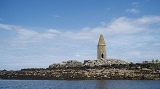
Ynys Dulas is a small island located off the north-east coast of Anglesey, Wales. It marks the most eastern part of the parish of Llaneilian.

Fuday is an uninhabited island of about 232 hectares and is one of ten islands in the Sound of Barra, a Site of Community Importance for conservation in the Outer Hebrides of Scotland. It lies just east of Scurrival Point on Barra and west of Eriskay. Fuday is owned by the Scottish Government. Deserted since 1901, its peak population is recorded only as seven.
SM UC-47 was a German Type UC II minelaying submarine or U-boat in the German Imperial Navy during World War I. The U-boat was ordered on 20 November 1915, laid down on 1 February 1916, and was launched on 30 August 1916. She was commissioned into the German Imperial Navy on 13 October 1916 as SM UC-47. In 13 patrols UC-47 was credited with sinking 58 ships, either by torpedo or by mines laid. UC-47 was rammed and depth charged by British patrol boat P-57, under the command of H.C. Birnie, off Flamborough Head on 18 November 1917. UC-47 went down with all hands.
German submarine U-979 was a Type VIIC U-boat built for Nazi Germany's Kriegsmarine for service during World War II. She was laid down on 10 August 1942 by Blohm & Voss, Hamburg as yard number 179, launched on 15 April 1943 and commissioned on 20 May 1943 under Kapitänleutnant Johannes Meermeier.

German submarine U-974 was a Type VIIC U-boat of Nazi Germany's Kriegsmarine during World War II.
The Japanese occupation of the Gilbert Islands was the period in the history of Kiribati between 1941 and 1945 when Imperial Japanese forces occupied the Gilbert Islands during World War II, in the Pacific War theatre.

Ha-201 was an Imperial Japanese Navy Ha-201-class submarine. Completed and commissioned in May 1945, she served during the final months of World War II. She surrendered at the end of the war in September 1945 and was scuttled in April 1946.

