Protected areas of Tasmania consist of protected areas located within Tasmania and its immediate onshore waters, including Macquarie Island. It includes areas of crown land managed by Tasmanian Government agencies as well as private reserves. As of 2016, 52% of Tasmania's land area has some form of reservation classification, the majority is managed by the Tasmania Parks & Wildlife Service. Marine protected areas cover about 7.9% of state waters.
Waratah-Wynyard Council is a local government body in Tasmania, situated in the north-west of the state. Waratah-Wynyard is classified as a rural local government area and has a population of 13,800, the major towns and localities of the region include Savage River, Sisters Beach, Somerset, Waratah and the principal town of Wynyard.

Wynyard (/ˈwɪnjɚd/) wi-nyuhd) is a rural town located on the North West coast of Tasmania, Australia. Wynyard is situated 17 kilometres (11 mi) west of Burnie. As of the 2021 census, Wynyard has an estimated population of 6,296 The town is a regional hub servicing the surrounding rural areas, the adjacent Burnie Wynyard Airport provides commercial flights to Melbourne and other districts. The main council offices for the Waratah-Wynyard local government area are located in Wynyard.

The electoral division of Murchison is one of the fifteen electorates in the Tasmanian Legislative Council, situated in the western/north-west region of the state. It is the largest electorate in size, covering an area of 19,391 km² and includes the municipalities of Circular Head, King Island, Waratah-Wynyard, West Coast and part of Burnie City.
Guildford is a rural locality in the local government area (LGA) of Waratah–Wynyard in the North-west and west LGA region of Tasmania. The locality is about 81 kilometres (50 mi) south of the town of Wynyard. The 2016 census has a population of nil for the state suburb of Guildford.

Burnie City Council is a local government body in Tasmania, located in the city and surrounds of Burnie in the north-west of the state. The Burnie local government area is classified as urban and has a population of 19,348, which also encompasses Cooee, Hampshire, Natone and Ridgley.
Beddomeia averni is a species of very small freshwater snail that has a gill and an operculum, an aquatic operculate gastropod mollusk in the family Hydrobiidae. This species is endemic to Australia. The Hydrobiidae snail has been categorized into four distinct groups: Beddomeia being one of them. Very little is known about their ecology and habitat. Low funding in Australia for the conservation of threatened species is partly responsible for this; moreover, there are only a few good sources that contribute to its limited data required to have a better understanding. Studies have shown that it is hard to distinguish the species from a morphology point of view. A non-taxonomist may find it arduous to tell differences among different members of the species. Therefore the anatomical study is incorporated to understand and differentiate them. It is found that human-led actions such as agriculture, forestry, mining, etc have caused major degradation in their population. Other factors such as changes in water conditions due to sedimentation, varying temperature, mineral level, salinity can either positively/negatively impact their population
Beddomeia camensis is a species of very small freshwater snail that is endemic to Australia. The invertebrate is 2-4 mm in size, it is a gastropod mollusk and belongs to the Hydrobiidae family, a large family of freshwater snails recognised by their small size and cosmopolitan distribution. Beddomeia camensis is one of the least populated species within its family distributed across only 5 small to medium-sized streams that flow into the Cam River catchment in North-West Tasmania.
Beddomeia capensis is an aquatic operculate gastropod mollusk, a species of very small freshwater snail that has a gill and an operculum, in the family Hydrobiidae. The species is classified as endangered and known to be endemic to five streams within a relatively small area on the island state of Tasmania, Australia. However, recent surveys have only been able to locate Beddomeia capensis in two small streams on Table Cape, with the total length of inhabited stream less than 80 metres (260 ft).

Beddomeia fultoni(B. fultoni) is a species of small freshwater snail belonging to the family Tateidae.

Beddomeia hallae, also known as Buttons Rivulet hydrobiid snail, is a species of small freshwater snail that is endemic to Australia. The species is an aquatic operculate gastropod mollusk in the family Hydrobiidae. Beddomeia hallae belongs to the genus Beddomeia, which is the largest group in the family Hydrobiidae, consisting of 47 species. In the Threatened Species Protection Act 1995, this species is one of the 37 Beddomeia species listed as endangered, however, on the International Union for Conservation of Nature Red List, the species is listed as vulnerable. Found in Tasmania, in the streams of Buttons Rivulet and Castra Rivulet, Beddomeia hallae is sighted in its natural habitat amongst wood, leaves and under stones. Nonetheless, the Beddomeia species including Beddomeia hallae are geographically isolated, existing within restricted ranges.
Beddomeia launcestonensis is a species of very small freshwater snail that has a gill and an operculum, an aquatic operculate gastropod mollusk in the family Hydrobiidae. This species is endemic to Australia.
Beddomeia minima is a population of freshwater snails that are endemic to Australia. It is commonly classified as a hydrobiid snail. This population was listed as Vulnerable on the IUCN Red List in 2011 due to its distribution being restricted to a single location and range of possible threats present in Tasmania. Beddomeia minima is one of a few fresh water snail species belonging to the same genus Beddomeia that survive in Tasmania, Australia, specifically a single location in the Scottsdale area.
Beddomeia waterhouseae, also known as Claytons Rivulet freshwater snail, is a species of freshwater snail in the family Tateidae. This species is endemic to northern Tasmania in Australia. The holotype specimen was found in a very small tributary of Little Clayton's Rivulet and is held at the Australian Museum. B. waterhouseae is small and as an adult has a shell measuring between 1.7 to 3.7 mm in length. The shell shape is ovate-conic to broadly conic and has a thin inner lip and no columellar bulge. This species feeds on algae and detritus on rocks. The female of the species lay single eggs in capsules made of sand grains and attached to the underside of rocks or wood. B. waterhouseae is considered vulnerable by the IUCN as it has a very small range and is sensitive to water quality and so may be threatened by disturbances of its habitat. Other threats include habitat loss. Conservation activities such as assessment of the aquatic ecosystem and vegetal surveys are being undertaken in an attempt to preserve this species.

The Cape Bruny Lighthouse is an inactive lighthouse located at the southern tip of Bruny Island, Tasmania, Australia.
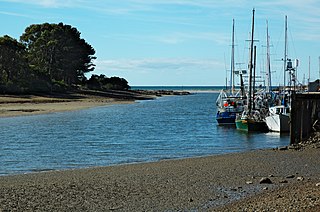
The Inglis River is a river in North West Tasmania, Australia, it extends approximately 61 kilometres (38 mi) from the Campbell Ranges near Takone before discharging into Bass Strait at Wynyard. The Flowerdale River is the largest tributary system on the Inglis River and makes up approximately one-third of the 471-square-kilometre (182 sq mi) Inglis-Flowerdale catchment basin.
The Tasmanian Heritage Register is the statutory heritage register of the Australian state of Tasmania. It is defined as a list of areas currently identified as having historic cultural heritage importance to Tasmania as a whole. The Register is kept by the Tasmanian Heritage Council within the meaning of the Tasmanian Historic Cultural Heritage Act 1995. It encompasses in addition the Heritage Register of the Tasmanian branch of the National Trust of Australia, which was merged into the Tasmanian Heritage Register. The enforcement of the heritage's requirements is managed by Heritage Tasmania.

The Detention Falls, a cascade waterfall on the Detention River, is located at Milabena in North West Tasmania, Australia.
Sisters Creek is a locality and small rural community in the local government areas of Waratah-Wynyard and Circular Head, in the North-west and west region of Tasmania. It is located about 18 kilometres (11 mi) north-west of the town of Wynyard. The Bass Highway passes through from east to west, and the watercourse named Sisters Creek flows through from south to north. The 2016 census determined a population of 134 for the state suburb of Sisters Creek.
Rocky Cape is a locality and small rural community in the local government areas of Circular Head and Waratah-Wynyard, in the North-west and west region of Tasmania. It is located about 30 kilometres (19 mi) north-west of the town of Wynyard. The Bass Highway passes through from south-east to north-west. The Rocky Cape National Park is in the north-east of the locality. The 2016 census determined a population of 206 for the state suburb of Rocky Cape.
 Table Cape Lighthouse in 1948
 Table Cape by dusk
 View from Table Cape lookout


