Shark Island is an island located with in Sydney Harbour, in New South Wales, Australia. The island is 1.5 hectares in area, measuring some 250 metres by 100 metres, and lies off the Sydney suburbs of Point Piper, Rose Bay and Vaucluse, in the eastern section of the harbour between the Harbour Bridge and the harbour entrance. The island was known by the local Aboriginal people as Boambilly, and the current name comes from its shape, which is claimed to resemble a shark.

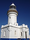
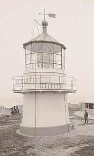
Hornby Lighthouse, also known as South Head Lower Light or South Head Signal Station, is a heritage-listed active lighthouse located on the tip of South Head, New South Wales, Australia, a headland to the north of the suburb Watsons Bay. It marks the southern entrance to Port Jackson and Sydney Harbour, as well as lighting the South Reef, a ledge of submerged rocks. It is the third oldest lighthouse in New South Wales. Designed by Mortimer Lewis and listed on the Register of the National Estate and on the New South Wales State Heritage Register since 2 April 1999, with the following statement of significance:
A dominant Sydney landmark which appears to have been in continuous use since the 1840s as a controlling point for shipping entering and leaving Port Jackson. The building complex, designed by the Colonial Architect Mortimer Lewis in the early 1840s, is an architectural important example of an early Victorian public work associated with port activities.
Grotto Point Light, also known as Port Jackson Entrance Range Front Light, is an active lighthouse located at Grotto Point, a rocky headland at the southernmost tip of Balgowlah Heights, New South Wales, Australia, on the north side of Sydney Harbour. It serves as the front range light, Rosherville Light serving as the rear light, into Port Jackson. Rosherville Light is located almost exactly 1 mile (1.6 km) behind Grotto Point Light.

The Bradleys Head Light is an active heritage-listed lighthouse at Bradleys Head, a headland protruding from the north shore of Sydney Harbour, within Mosman, Mosman Council, Sydney, New South Wales, Australia. It is the sibling of Robertson Point Light. The site is owned and managed as part of the Sydney Harbour National Park by the NSW National Parks and Wildlife Service, an agency of the Government of New South Wales; while the light is managed and operated by Sydney Ports Corporation. It was added to the New South Wales State Heritage Register on 18 April 2000.

Burrewarra Point Light is an active lighthouse located at Burrewarra Point, New South Wales, Australia, which is north of Broulee and 25 kilometres (16 mi) to the south of Batemans Bay.
Cape Baily Light is an active lighthouse located at Cape Baily, a headland at the south side of the entrance to Botany Bay, New South Wales, Australia. The light serves to help north-bound shipping hug the coast to avoid the strong southerly currents further out to sea.
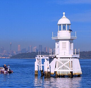
Eastern Channel Pile Light, also known as the East Wedding Cake due to its shape, is an active pile lighthouse located at the Sydney Harbour, New South Wales, Australia, off Laings Point in the Vaucluse suburb of Sydney. It marks the eastern end of the Sow and Pigs Reef.

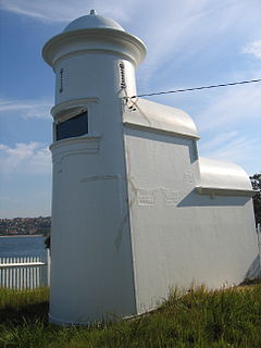
Fort Denison Light, also known as Pinchgut Light, is an active lighthouse located on top of a Martello Tower at Fort Denison, a former penal site and defensive facility occupying a small island in Sydney Harbour, New South Wales, Australia. The island is located downstream from the Harbour Bridge near Potts Point and the Royal Botanic Gardens. The fort is also known as "Pinchgut" lending its name to the light.

Kiama Light, also known as Kiama Harbour Light, is an active lighthouse in Kiama, New South Wales, Australia. The lighthouse is located close to the Kiama Blowhole on Blowhole Point, south of Kiama Harbour.
Nobbys Head Light is an active lighthouse on Nobbys Head, a headland on the south side of the entrance to Newcastle Harbour, New South Wales, Australia. An image of the lighthouse is included in the Coat of Arms of the City of Newcastle.

Robertson Point Light, also known as Cremorne Point Light, is an active lighthouse in Cremorne Point, a suburb on the lower North Shore of Sydney, New South Wales, Australia. It is the sibling of Bradleys Head Light.

Parriwi Head Light, also known as Rosherville Light and Port Jackson Entrance Range Rear Light, is an active lighthouse located just off Parriwi Road, near Rosherville Reserve on the south side of Middle Harbour in Mosman, New South Wales, Australia. It serves as the rear range light, Grotto Point Light serving as the front light, into Port Jackson. Grotto Point Light is located almost exactly 1 mile (1.6 km) in front of Parriwi Head Light.

Vaucluse Bay Range Front Light is an active lighthouse located on the east side of the entrance to Vaucluse Bay in Vaucluse, New South Wales, Australia. It serves as the front range light into Vaucluse Bay. The distance between the lights is 945 metres (3,100 ft).
Vaucluse Bay Range Rear Light is an active lighthouse located on the east side of the entrance to Vaucluse Bay in Vaucluse, New South Wales, Australia. It serves as the rear range light companion to the Vaucluse Bay Range Front Light, into Vaucluse Bay. The distance between the two lights is 945 metres (3,100 ft).
South Solitary Island Light is an active lighthouse on South Solitary Island, an island within the Solitary Islands Marine Park, about 15 kilometres (9.3 mi) northeast of Coffs Harbour, New South Wales, Australia. The lighthouse is located at the summit of the island. It is considered the most isolated lighthouse on the New South Wales coast. It was first in New South Wales to use kerosene over colza oil, and the last to do so before converting to electric power.

Western Channel Pile Light, also known as the West Wedding Cake due to its shape, is an active pile lighthouse located at the Sydney Harbour, New South Wales, Australia, off Georges Head at Mosman. It marks the western end of the Sow and Pigs Reef. It collapsed in December 2006 and was reconstructed and restored to operation in December 2008.

The Wollongong Head Lighthouse, also known as Flagstaff Hill Lighthouse or Flagstaff Point Light, is an active lighthouse located adjacent to the heritage-listed Wollongong Harbour precinct in Wollongong, a coastal city south of Sydney, New South Wales, Australia. It overlooks the Tasman Sea from the top of Flagstaff Point, directly east of the city centre. Wollongong is the only place in the east of Australia to have two lighthouses located in close proximity of each other, the other being Wollongong Breakwater Lighthouse.

Warden Head Light, also known as Ulladulla Lighthouse, is an active lighthouse on Warden Head, a headland south of Ulladulla, New South Wales, Australia, guarding the entrance to the Port of Ulladulla. It is one of only two wrought iron lighthouses in New South Wales, the other being its sibling, Wollongong Breakwater Lighthouse. It is also notable for two relocations: the tower was constructed in 1873 on the Ulladulla Breakwater, and relocated in 1889 to its current location. Its keeper's house was relocated to a different location in the 1920s.

Point Cartwright Light is an active lighthouse located on Point Cartwright, a point near the mouth of the Mooloolah River, in Mooloolaba, Queensland, Australia. It marks the entrance to the North West Channel, a deep water channel into Moreton Bay and the Port of Brisbane, and provides guidance into the Mooloolaba Harbour.