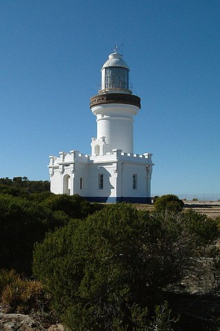
The Macquarie Lighthouse, also known as South Head Upper Light, is the first, and is the longest serving, lighthouse site in Australia. It is located on Dunbar Head, on Old South Head Road, Vaucluse in the Municipality of Woollahra local government area of New South Wales, Australia. The lighthouse is situated approximately 2 kilometres (1 mi) south of South Head near the entrance to Sydney Harbour. There has been a navigational aid in this vicinity since 1791 and a lighthouse near the present site since 1818. The current heritage-listed lighthouse was completed in 1883. The lighthouse and associated buildings were designed by James Barnet and built from 1881 to 1883.

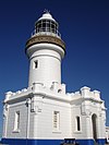
Hornby Lighthouse, also known as South Head Lower Light or South Head Signal Station, is a heritage-listed active lighthouse located on the tip of South Head, New South Wales, Australia, a headland to the north of the suburb Watsons Bay. It marks the southern entrance to Port Jackson, as well as lighting the South Reef, a ledge of submerged rocks. It is the third oldest lighthouse in New South Wales. Designed by Mortimer Lewis and listed on the Register of the National Estate and on the New South Wales State Heritage Register since 2 April 1999, with the following statement of significance:
A dominant Sydney landmark which appears to have been in continuous use since the 1840s as a controlling point for shipping entering and leaving Port Jackson. The building complex, designed by the Colonial Architect Mortimer Lewis in the early 1840s, is an architectural important example of an early Victorian public work associated with port activities.
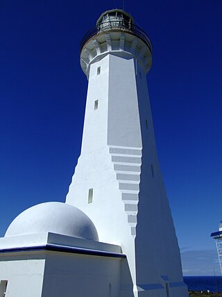
The Green Cape Lighthouse is a heritage-listed lighthouse located at the tip of Green Cape, a headland forming the northern boundary of Disaster Bay, in southern New South Wales, Australia. It is the southernmost lighthouse in New South Wales and Australia's first lighthouse built in concrete. At 29 metres (95 ft) it is also the tallest lighthouse in New South Wales. It marks Green Cape on the northerly shore-hugging sailing course.

The Sea Girt Light is a decommissioned lighthouse marking the inlet leading to the Wreck Pond in Sea Girt, New Jersey, United States. It is located on a stretch of the New Jersey shore between the Barnegat and Navesink lighthouses. It hosted the first radio beacon mounted in a shore installation in the United States.

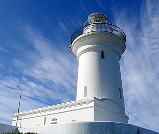
Tacking Point Lighthouse is Australia's thirteenth oldest lighthouse. It was built on a rocky headland about 8 kilometres south of Port Macquarie in 1879 by Shepherd and Joseph William Mortley, to a design by the New South Wales Colonial Architect, James Barnet. It is operated by the Australian Maritime Safety Authority and is classified by the National Trust of Australia (NSW).

Richmond River Light, also known as Ballina Head Light and Ballina Light, is an active lighthouse located at Ballina Head, a headland in Ballina, New South Wales, Australia. The headland is at the northern side of the entrance to the Richmond River. It used to serve to guide ships into the river port and is used also serves as a leading light into the river, together with a steamer's masthead lantern with a 200 mm lens which is raised on a wooden structure 30 metres (98 ft) from it.

Crookhaven Heads Light is an active lighthouse located at Crookhaven Heads, a headland on the south side of the entrance to the Shoalhaven River, north of Culburra Beach, New South Wales, Australia. Together with a movable light flashing yellow every 2s it serves as a range light into the channel. The lighthouse is in a severely deteriorated condition, and considered by some the most endangered lighthouse in New South Wales, suffering from repeated vandalization.

Fingal Head Light is an active lighthouse located at Fingal Head, New South Wales, Australia, a headland about 5 kilometres (3.1 mi) south of Point Danger, which marks the Queensland border.
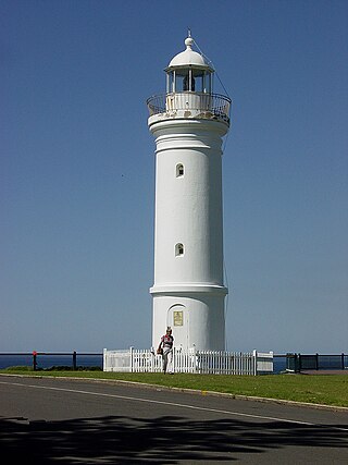
Kiama Light, also known as Kiama Harbour Light, is an active lighthouse in Kiama, New South Wales, Australia. The lighthouse is located close to the Kiama Blowhole on Blowhole Point, south of Kiama Harbour.

Norah Head Light is an active lighthouse located at Norah Head, a headland on the Central Coast, New South Wales, Australia, close to Toukley. It is the last lighthouse of the James Barnet style to be built, and the last staffed lighthouse constructed in New South Wales.
Point Perpendicular Light is a lighthouse located on Point Perpendicular, a point at the southern tip of the Beecroft Peninsula, in New South Wales, Australia. It marks the northern entrance to Jervis Bay. The historic lighthouse was active from 1889 to 1993 and is still present, though its future is unclear. It is believed to be the first lighthouse in New South Wales which was built of precast concrete blocks. The light was replaced in 1993 with a skeletal tower which is active.

The Point Stephens Light is a heritage-listed active lighthouse located on Point Stephens, a point on an unnamed headland at the east of Fingal Bay, 4.25 km (2.64 mi) south of the entrance of Port Stephens, New South Wales, Australia. The light serves to assist vessels entering Port Stephens. It is considered an endangered lighthouse due to remote location and old age.
South Solitary Island Light is an active lighthouse on South Solitary Island, an island within the Solitary Islands Marine Park, about 15 kilometres (9.3 mi) northeast of Coffs Harbour, New South Wales, Australia. The lighthouse is located at the summit of the island. It is considered the most isolated lighthouse on the New South Wales coast. It was first in New South Wales to use kerosene over colza oil, and the last to do so before converting to electric power.

Sugarloaf Point Light, also known as Seal Rocks Lighthouse, is an active lighthouse located on Sugarloaf Point, a point about 3 kilometres (1.9 mi) southeast of Seal Rocks, Mid-Coast Council, New South Wales, Australia. It guards Seal Rocks, a treacherous rock formation to the south. It is the first lighthouse designed by James Barnet, and built from 1874 to 1875 by John McLeod. It is also one of only two towers in Australia with an external stairway. It is also known as Sugarloaf Point Lightstation Group, Seal Rocks Lightstation Complex and Sugarloaf Point Lighthouse. The property is owned by National Parks and Wildlife Service. It was added to the Commonwealth Heritage List on 22 June 2004; on the New South Wales State Heritage Register on 22 February 2019; and on the Register of the National Estate on 10 April 1989.

Warden Head Light, also known as Ulladulla Lighthouse, is an active lighthouse on Warden Head, a headland south of Ulladulla, New South Wales, Australia, guarding the entrance to the Port of Ulladulla. It is one of only two wrought iron lighthouses in New South Wales, the other being its sibling, Wollongong Breakwater Lighthouse. It is also notable for two relocations: the tower was constructed in 1873 on the Ulladulla Breakwater, and relocated in 1889 to its current location. Its keeper's house was relocated to a different location in the 1920s.

Clarence River Light, also known as Yamba Light or Clarence Head Light, is an active lighthouse located on Pilot Hill, a hill in Wooli Park, Yamba, New South Wales, Australia, south of the entrance of Clarence River. The current lighthouse was built in 1955, replacing a previous lighthouse built in 1880. It serves as the rear range light for two different ranges.

Booby Island Light is an active heritage-listed lighthouse located on Booby Island in the Shire of Torres, near the tip of Cape York Peninsula, west of Prince of Wales Island, within the Endeavour Strait, Queensland, Australia. It marks the western entrance to the navigation channel through the Torres Strait. It was the last of the major lights to be constructed along the Queensland coast.

Point Danger Light, also known as the Captain Cook Memorial Light, is an active lighthouse located on Point Danger, a headland between Coolangatta and Tweed Heads, marking the border between Queensland and New South Wales, Australia. It lays claim to be the first lighthouse in the world to experiment with laser as a light source.

Cape Bowling Green Light is an active lighthouse on Cape Bowling Green, a long headland ending in a long low sandspit, about 30 kilometres (19 mi) from Ayr, Queensland, Australia. The lighthouse is at the end of the headland, near the base of the sandspit. The first lighthouse at the location, established in 1874, was moved multiple times. It was prefabricated in Brisbane, shipped to the location, moved twice due to coastal erosion and finally transferred for display at the Australian National Maritime Museum at Darling Harbour in Sydney.