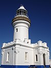
The Macquarie Lighthouse, also known as South Head Upper Light, is the first, and is the longest serving, lighthouse site in Australia. It is located on Dunbar Head, on the Old South Head Road, Vaucluse in the Municipality of Woollahra local government area of New South Wales, Australia. The lighthouse is situated approximately 2 kilometres (1 mi) south of South Head near the entrance to Sydney Harbour. There has been a navigational aid in this vicinity since 1791 and a lighthouse near the present site since 1818. The current heritage-listed lighthouse was completed in 1883. The lighthouse and associated buildings were designed by James Barnet and built from 1881 to 1883.

Shark Island is an island located with in Sydney Harbour, in New South Wales, Australia. The island is 1.5 hectares in area, measuring some 250 metres by 100 metres, and lies off the Sydney suburbs of Point Piper, Rose Bay and Vaucluse, in the eastern section of the harbour between the Harbour Bridge and the harbour entrance. The island was known by the local Aboriginal people as Boambilly, and the current name comes from its shape, which is claimed to resemble a shark.
Grotto Point Light, also known as Port Jackson Entrance Range Front Light, is an active lighthouse located at Grotto Point, a rocky headland at the southernmost tip of Balgowlah Heights, New South Wales, Australia, on the north side of Sydney Harbour. It serves as the front range light, Rosherville Light serving as the rear light, into Port Jackson. Rosherville Light is located almost exactly 1 mile (1.6 km) behind Grotto Point Light.

Burrewarra Point Light is an active lighthouse located at Burrewarra Point, New South Wales, Australia, which is north of Broulee and 25 kilometres (16 mi) to the south of Batemans Bay.
Cape Baily Light is an active lighthouse located at Cape Baily, a headland at the south side of the entrance to Botany Bay, New South Wales, Australia. The light serves to help north-bound shipping hug the coast to avoid the strong southerly currents further out to sea.

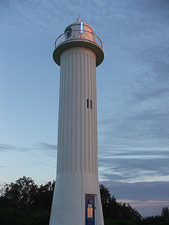
Crowdy Head Light is an active lighthouse located at Crowdy Head, a headland between Forster and Port Macquarie, New South Wales, Australia. It is registered with the Register of the National Estate.
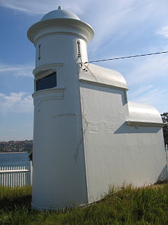
Eastern Channel Pile Light, also known as the East Wedding Cake due to its shape, is an active pile lighthouse located at the Sydney Harbour, New South Wales, Australia, off Laings Point in the Vaucluse suburb of Sydney. It marks the eastern end of the Sow and Pigs Reef.

Kiama Light, also known as Kiama Harbour Light, is an active lighthouse in Kiama, New South Wales, Australia. The lighthouse is located close to the Kiama Blowhole on Blowhole Point, south of Kiama Harbour.

Parriwi Head Light, also known as Rosherville Light and Port Jackson Entrance Range Rear Light, is an active lighthouse located just off Parriwi Road, near Rosherville Reserve on the south side of Middle Harbour in Mosman, New South Wales, Australia. It serves as the rear range light, Grotto Point Light serving as the front light, into Port Jackson. Grotto Point Light is located almost exactly 1 mile (1.6 km) in front of Parriwi Head Light.

Vaucluse Bay Range Front Light is an active lighthouse located on the east side of the entrance to Vaucluse Bay in Vaucluse, New South Wales, Australia. It serves as the front range light into Vaucluse Bay. The distance between the lights is 945 metres (3,100 ft).

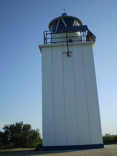
Point Perpendicular Light is a lighthouse located on Point Perpendicular, a point at the southern tip of the Beecroft Peninsula, in New South Wales, Australia. It marks and the northern entrance to Jervis Bay. The historic lighthouse was active from 1889 to 1993 and is still present, though its future is unclear. It is believed to be the first lighthouse in New South Wales which was built of precast concrete blocks. The light was replaced in 1993 with a skeletal tower which is active.

The Point Stephens Light is a heritage-listed active lighthouse located on Point Stephens, a point on an unnamed headland at the east of Fingal Bay, 4.25 km (2.64 mi) south of the entrance of Port Stephens, New South Wales, Australia. The light serves to assist vessels entering Port Stephens. It is considered an endangered lighthouse due to remote location and old age.

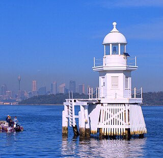
Shark Island Light is an active pile lighthouse located just north of Shark Island, an island in Sydney Harbour, New South Wales, Australia. Its light is only visible on in the fairway of the harbour, between Shark Point and Point Piper.

Western Channel Pile Light, also known as the West Wedding Cake due to its shape, is an active pile lighthouse located at the Sydney Harbour, New South Wales, Australia, off Georges Head at Mosman. It marks the western end of the Sow and Pigs Reef. It collapsed in December 2006 and was reconstructed and restored to operation in December 2008.
Clarence River Light, also known as Yamba Light or Clarence Head Light, is an active lighthouse located on Pilot Hill, a hill in Wooli Park, Yamba, New South Wales, Australia, south of the entrance of Clarence River. The current lighthouse was built in 1955, replacing a previous lighthouse built in 1880. It serves as the rear range light for two different ranges.

Bulwer Island Light, also known as Bulwer Island Range Rear Light, is an inactive lighthouse that used to be located on Bulwer Island, in the city of Brisbane, Queensland, Australia. In 1983 it was moved to the Queensland Maritime Museum in Brisbane.

Sea Hill Lighthouse, also known as Sea Hill Point Light or Little Sea Hill Light, is a lighthouse on the northwest point of Curtis Island, Gladstone Region, Queensland, Australia. Its purpose was to mark the east side of the entrance to Keppel Bay, on passage to Fitzroy River and Port Alma. The first lighthouse at the locations was constructed in 1873 or 1876, moved in the 1920s, and is now on display at the Gladstone Maritime Museum. A second lighthouse was constructed in 1895 and its state is unclear.

Goods Island Light is an active lighthouse located on the highest point of Goods Island (Palilag), an island in the Torres Strait, belonging to Queensland, Australia. It serves as the rear light of the Goods Island Range, pointing out the entrance to Normanby Sound.

Cape Moreton Light, also listed as North Point Range Rear Light, is a heritage-listed active lighthouse located on Cape Moreton, a rocky headland located at the north eastern tip of Moreton Island, a large sand island on the eastern side of Moreton Bay, on the coast of South East Queensland, Australia. It marks the northern entrance to Moreton Bay and Brisbane and also serves as the rear light for the North Point Range. With its two distinctive red bands, it also serves as a daymark. It is the oldest lighthouse in Queensland, and the only one to be built by the New South Wales Government before the separation of Queensland, which took place in 1859. It is also the only lighthouse in Queensland to be built of stone.