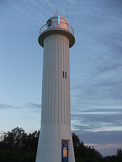
The Green Cape Lighthouse is a heritage-listed lighthouse located at the tip of Green Cape, a headland forming the northern boundary of Disaster Bay, in southern New South Wales, Australia. It is the southernmost lighthouse in New South Wales and Australia's first lighthouse built in concrete. At 29 metres (95 ft) it is also the second tallest lighthouse in New South Wales. It marks Green Cape on the northerly shore-hugging sailing course.
Grotto Point Light, also known as Port Jackson Entrance Range Front Light, is an active lighthouse located at Grotto Point, a rocky headland at the southernmost tip of Balgowlah Heights, New South Wales, Australia, on the north side of Sydney Harbour. It serves as the front range light, Rosherville Light serving as the rear light, into Port Jackson. Rosherville Light is located almost exactly 1 mile (1.6 km) behind Grotto Point Light.

Burrewarra Point Light is an active lighthouse located at Burrewarra Point, New South Wales, Australia, which is north of Broulee and 25 kilometres (16 mi) to the south of Batemans Bay.

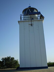
Richmond River Light, also known as Ballina Head Light and Ballina Light, is an active lighthouse located at Ballina Head, a headland in Ballina, New South Wales, Australia. The headland is at the northern side of the entrance to the Richmond River. It used to serve to guide ships into the river port and is used also serves as a leading light into the river, together with a steamer's masthead lantern with a 200 mm lens which is raised on a wooden structure 30 metres (98 ft) from it.

Crookhaven Heads Light is an active lighthouse located at Crookhaven Heads, a headland on the south side of the entrance to the Shoalhaven River, north of Culburra Beach, New South Wales, Australia. Together with a movable light flashing yellow every 2s it serves as a range light into the channel. The lighthouse is in a severely deteriorated condition, and considered by some the most endangered lighthouse in New South Wales, suffering from repeated vandalization.

Crowdy Head Light is an active lighthouse located at Crowdy Head, a headland between Forster and Port Macquarie, New South Wales, Australia. It is registered with the Register of the National Estate.

Fort Denison Light, also known as Pinchgut Light, is an active lighthouse located on top of a Martello Tower at Fort Denison, a former penal site and defensive facility occupying a small island in Sydney Harbour, New South Wales, Australia. The island is located downstream from the Harbour Bridge near Potts Point and the Royal Botanic Gardens. The fort is also known as "Pinchgut" lending its name to the light.

Kiama Light, also known as Kiama Harbour Light, is an active lighthouse in Kiama, New South Wales, Australia. The lighthouse is located close to the Kiama Blowhole on Blowhole Point, south of Kiama Harbour.
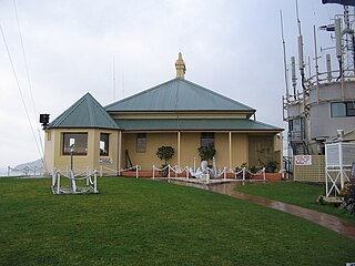
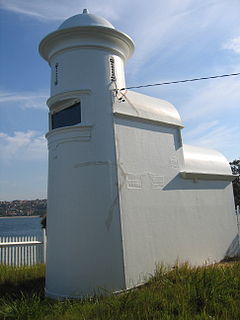
Nelson Head Light, also known as Nelson Head Inner Light, is an inactive, unusual lighthouse on Nelson Head, a headland northeast of the town of Nelson Bay, New South Wales, Australia, near Halifax Park, on the southern shore of Port Stephens. The light guided ships into the port. Unlike other lighthouses, the Nelson Head Light has no tower, but was shown through the window of the lantern room, and later mounted outside.
Nobbys Head Light is an active lighthouse on Nobbys Head, a headland on the south side of the entrance to Newcastle Harbour, New South Wales, Australia. An image of the lighthouse is included in the Coat of Arms of the City of Newcastle.

Parriwi Head Light, also known as Rosherville Light and Port Jackson Entrance Range Rear Light, is an active lighthouse located just off Parriwi Road, near Rosherville Reserve on the south side of Middle Harbour in Mosman, New South Wales, Australia. It serves as the rear range light, Grotto Point Light serving as the front light, into Port Jackson. Grotto Point Light is located almost exactly 1 mile (1.6 km) in front of Parriwi Head Light.

Vaucluse Bay Range Front Light is an active lighthouse located on the east side of the entrance to Vaucluse Bay in Vaucluse, New South Wales, Australia. It serves as the front range light into Vaucluse Bay. The distance between the lights is 945 metres (3,100 ft).
Vaucluse Bay Range Rear Light is an active lighthouse located on the east side of the entrance to Vaucluse Bay in Vaucluse, New South Wales, Australia. It serves as the rear range light companion to the Vaucluse Bay Range Front Light, into Vaucluse Bay. The distance between the two lights is 945 metres (3,100 ft).

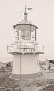
Point Perpendicular Light is a lighthouse located on Point Perpendicular, a point at the southern tip of the Beecroft Peninsula, in New South Wales, Australia. It marks and the northern entrance to Jervis Bay. The historic lighthouse was active from 1889 to 1993 and is still present, though its future is unclear. It is believed to be the first lighthouse in New South Wales which was built of precast concrete blocks. The light was replaced in 1993 with a skeletal tower which is active.

The Point Stephens Light is a heritage-listed active lighthouse located on Point Stephens, a point on an unnamed headland at the east of Fingal Bay, 4.25 km (2.64 mi) south of the entrance of Port Stephens, New South Wales, Australia. The light serves to assist vessels entering Port Stephens. It is considered an endangered lighthouse due to remote location and old age.

Shark Island Light is an active pile lighthouse located just north of Shark Island, an island in Sydney Harbour, New South Wales, Australia. Its light is only visible on in the fairway of the harbour, between Shark Point and Point Piper.

Warden Head Light, also known as Ulladulla Lighthouse, is an active lighthouse on Warden Head, a headland south of Ulladulla, New South Wales, Australia, guarding the entrance to the Port of Ulladulla. It is one of only two wrought iron lighthouses in New South Wales, the other being its sibling, Wollongong Breakwater Lighthouse. It is also notable for two relocations: the tower was constructed in 1873 on the Ulladulla Breakwater, and relocated in 1889 to its current location. Its keeper's house was relocated to a different location in the 1920s.
Clarence River Light, also known as Yamba Light or Clarence Head Light, is an active lighthouse located on Pilot Hill, a hill in Wooli Park, Yamba, New South Wales, Australia, south of the entrance of Clarence River. The current lighthouse was built in 1955, replacing a previous lighthouse built in 1880. It serves as the rear range light for two different ranges.

Point Cartwright Light is an active lighthouse located on Point Cartwright, a point near the mouth of the Mooloolah River, in Mooloolaba, Queensland, Australia. It marks the entrance to the North West Channel, a deep water channel into Moreton Bay and the Port of Brisbane, and provides guidance into the Mooloolaba Harbour.