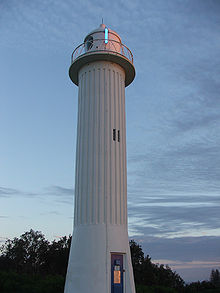
Richmond River Light, also known as Ballina Head Light and Ballina Light, is an active lighthouse located at Ballina Head, a headland in Ballina, New South Wales, Australia. The headland is at the northern side of the entrance to the Richmond River. It used to serve to guide ships into the river port and is used also serves as a leading light into the river, together with a steamer's masthead lantern with a 200 mm lens which is raised on a wooden structure 30 metres (98 ft) from it.

Crowdy Head Light is an active lighthouse located at Crowdy Head, a headland between Forster and Port Macquarie, New South Wales, Australia. It is registered with the Register of the National Estate.
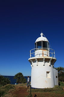
Fingal Head Light is an active lighthouse located at Fingal Head, New South Wales, Australia, a headland about 5 kilometres (3.1 mi) south of Point Danger, which marks the Queensland border.

Fort Denison Light, also known as Pinchgut Light, is an active lighthouse located on top of a Martello Tower at Fort Denison, a former penal site and defensive facility occupying a small island in Sydney Harbour, New South Wales, Australia. The island is located downstream from the Harbour Bridge near Potts Point and the Royal Botanic Gardens. The fort is also known as "Pinchgut" lending its name to the light.

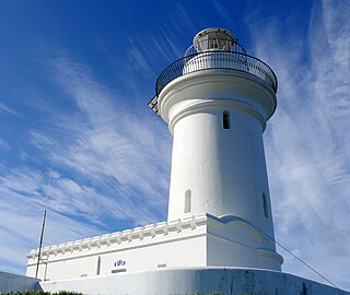
Kiama Light, also known as Kiama Harbour Light, is an active lighthouse in Kiama, New South Wales, Australia. The lighthouse is located close to the Kiama Blowhole on Blowhole Point, south of Kiama Harbour.
Nelson Head Light, also known as Nelson Head Inner Light, is an inactive, unusual lighthouse on Nelson Head, a headland northeast of the town of Nelson Bay, New South Wales, Australia, near Halifax Park, on the southern shore of Port Stephens. The light guided ships into the port. Unlike other lighthouses, the Nelson Head Light has no tower, but was shown through the window of the lantern room, and later mounted outside.

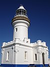
Norah Head Light is an active lighthouse located at Norah Head, a headland on the Central Coast, New South Wales, Australia, close to Toukley. It is the last lighthouse of the James Barnet style to be built, and the last staffed lighthouse constructed in New South Wales.

North Solitary Island Light is an active lighthouse on North Solitary Island, a large island off the coast of New South Wales, Australia. The light is located on the summit of the island which is on the northern section of the island.
South Solitary Island Light is an active lighthouse on South Solitary Island, an island within the Solitary Islands Marine Park, about 15 kilometres (9.3 mi) northeast of Coffs Harbour, New South Wales, Australia. The lighthouse is located at the summit of the island. It is considered the most isolated lighthouse on the New South Wales coast. It was first in New South Wales to use kerosene over colza oil, and the last to do so before converting to electric power.

Western Channel Pile Light, also known as the West Wedding Cake due to its shape, is an active pile lighthouse located at the Sydney Harbour, New South Wales, Australia, off Georges Head at Mosman. It marks the western end of the Sow and Pigs Reef. It collapsed in December 2006 and was reconstructed and restored to operation in December 2008.
East Vernon Light is an active lighthouse in the Northern Territory of Australia located in the Clarence Strait on the southern coast of East Vernon Island. The lighthouse guards the northeastern approach to Darwin.

Emery Point Light is an active lighthouse located at Larrakeyah Barracks, the main base for the Australian Defence Force in Northern Territory, Australia, at the entrance to Port Darwin. It was the second lighthouse to be built in Port Darwin. It was the only navigational aid to remain functional in the path of Cyclone Tracy.

Point Charles Light, known officially as the Charles Point Lighthouse, is an active lighthouse located on a headland at the northern end of the Cox Peninsula, 21 kilometres (13 mi) northwest of Port Darwin, Northern Territory, Australia. Established in 1893, it is the oldest lighthouse in the Northern Territory.

Sandy Cape Light is a heritage-listed active lighthouse located on Sandy Cape, the most northern point on K'gari, Queensland, Australia. It stands about 6 kilometres (3.7 mi) southwest of the northeastern tip of the island. It is the tallest lighthouse in Queensland. Built in 1870, it is the second major lighthouse to be built in Queensland after its formation in 1859. It is one of the first lighthouses in Australia to be constructed using bolted prefabricated segments of cast iron, and one of only two such lighthouses in Queensland, the other being its sibling, Bustard Head Light.

Cape Capricorn Light is an active heritage-listed lighthouse located on Cape Capricorn, a coastal headland on the northeast point of Curtis Island, in Gladstone Region, Central Queensland, Australia. The lighthouse, constructed in 1964, is the third at this site, following a timber frame lighthouse constructed in 1875 and a concrete lighthouse constructed around 1937. It was added to the Queensland Heritage Register on 31 August 2001.

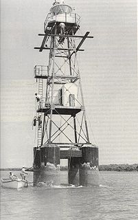
Cape Bowling Green Light is an active lighthouse located on Cape Bowling Green, a lengthy headland ending with a long low sandspit, about 30 kilometres (19 mi) from Ayr, Queensland, Australia. The lighthouse is at the end of the headland, near the base of the sandspit. The first lighthouse at the location, established in 1874, was moved multiple times. It was prefabricated in Brisbane, shipped to the location, moved twice due to coastal erosion and finally transferred for display at the Australian National Maritime Museum at Darling Harbour in Sydney.

Cape Moreton Light, also listed as North Point Range Rear Light, is a heritage-listed active lighthouse located on Cape Moreton, a rocky headland located at the north eastern tip of Moreton Island, a large sand island on the eastern side of Moreton Bay, on the coast of South East Queensland, Australia. It marks the northern entrance to Moreton Bay and Brisbane and also serves as the rear light for the North Point Range. With its two distinctive red bands, it also serves as a daymark. It is the oldest lighthouse in Queensland, and the only one to be built by the New South Wales Government before the separation of Queensland, which took place in 1859. It is also the only lighthouse in Queensland to be built of stone.

Dent Island Light is an active lighthouse on Dent Island, a small island off the coast of Queensland, Australia, part of the Whitsunday Group of the Whitsunday Islands. Located on the southwest tip of the island, the light guides ships navigating the Whitsunday Passage, between Whitsunday Island and the islands to the west, and marks the Dent Island Passage.

Pine Islet Light, also known as Percy Isles Light, is an active lighthouse located at Pine Islet, a small islet belonging to the Percy Isles group of the Northumberland Islands, about 130 kilometres (81 mi) southeast of Mackay, Queensland, Australia. The original lighthouse, established 1885, was active for a hundred years, until it was deactivated in 1985, by then the last kerosene powered lighthouse in Australia. It was relocated to the Mackay Marina in 1985 and restored to full working condition, making it the last fully functional kerosene operated lighthouse in the world. At the original location now stands a modern fiberglass tower.