Richmond River Light

Last updated

Richmond River Light
Richmond River Lighthouse.jpg
Richmond River Light, 2006
Richmond River Light
Location Ballina, New South Wales
Australia
Coordinates 28°52′1.31″S153°35′30.49″E / 28.8670306°S 153.5918028°E / -28.8670306; 153.5918028
Tower
Constructed1866
Constructionstone tower [1]
Automated1920 [2]
Height25 feet (7.6 m) [3]
Shapecylindrical tower with balcony and lantern
Markingswhite tower and lantern
Power sourcemains electricity  OOjs UI icon edit-ltr-progressive.svg
OperatorNSW Maritime
Light
First lit1880 [4]
Focal height115 feet (35 m)
Lens4th order catadioptric (original), 2nd order Chance Brothers Fresnel lens [5] (current)
Intensity28,000  cd
Range14 nautical miles (26 km; 16 mi) [6]
Characteristic Fl (4) W  16s.

Richmond River Light, also known as Ballina Head Light and Ballina Light, is an active lighthouse located at Ballina Head, a headland in Ballina, New South Wales, Australia. The headland is at the northern side of the entrance to the Richmond River. It used to serve to guide ships into the river port and is used also serves as a leading light into the river, together with a steamer's masthead lantern with a 200 mm lens which is raised on a wooden structure 30 metres (98 ft) from it. [7]

Contents

The nearby beach, Lighthouse Beach, one of Ballina's main beaches, is named for it. [8]

History

A historic view of Richmond River Light. Ballina Lighthouse historic cropped.JPG
A historic view of Richmond River Light.

The station was established with a temporary light that was installed in 1866 from plans by James Barnet, at the same time of the installation of the Clarence River Light. [9] [7]

The current lighthouse is one of five lighthouses of similar design designed and built by James Barnet in 1878–80, the other four being Fingal Head Light, Clarence River Light (now demolished), Tacking Point Lighthouse and Crowdy Head Light. A tender was called in 1878, it was built in 1879 and lit in 1880. [9]

The apparatus was a fixed light 4th order catadioptric apparatus of less than 1000 cd and was visible for 12 nautical miles (22 km; 14 mi). [10] It was powered by colza oil. [9] As the light was operated in conjunction with a nearby pilot station, only one light keeper was required. [7]

Demolition of the porch and annexe, November 1940 Richmond River Light - during demolition of annexe, November 1940.jpg
Demolition of the porch and annexe, November 1940

In 1920 the light was converted to acetylene gas and automated. [9] In November 1940, the annexe and the porch connected to the lighthouse were demolished. [11]

The light was electrified in the 1960s. The current light source is a 28,000  cd, 1,000  Watt 120  Volt tungsten-halogen lamp, and the power source is the Mains with a Battery standby. [9] It shows a light characteristic of four white flashes every 16 s (Fl.(4)W. 16s) [12]

Structure

The lighthouse in 1930 Richmond River Light, 1930.jpg
The lighthouse in 1930

The tower is very similar in design to the other four lighthouses. [7] It is circular, 6 feet (1.8 m) in diameter (internally), with walls tapering from 19 inches (480 mm) at the bottom to 14 inches (360 mm) at the top. [7] The tower is constructed of stone, [1] and cement rendered, and painted white. [7] On top of the tower there is an oversailing bluestone platform, supported at by twelve bluestone corbels, at about 12 feet (3.7 m) above the ground. The platform can be reached by an iron stair inside the tower. Around the perimeter of the platform is a metal handrail. The platform is topped by the simple metal dome which houses the optical apparatus. [7]

Originally the lighthouse had a porch, rectangular annexe for the duty room and oil store. These were all demolished in November 1940. [11] A one-story keeper's house is still present at the premises. [13]

A sign near the entry of the lighthouse regarding historical significance including entry on the Register of the National Estate. Richmond River Light, sign near entry regarding historical significance.jpg
A sign near the entry of the lighthouse regarding historical significance including entry on the Register of the National Estate.

Site operation

Richmond River Lighthouse is listed on the Register of National Estate held by the Australian Heritage Commission (Commonwealth Government) in 1983; this listing is defunct as this list was closed in 2007. [14] However, it is also listed under the North Coast Regional Environmental Plan 1988 and the Ballina Local Environmental Plan 1987. [15]

The light is currently operated by Transport for NSW [16] and the site is managed by the New South Wales Department of Lands. [13]

Inforrnamtion about the lighthouse on interpretive signage around Shaws Bay, East Ballina. This is a part of the sign series "Historic Ballina Waterfront". A friendly light in the night, interpretive signage around Shaws Bay, East Ballina.jpg
Inforrnamtion about the lighthouse on interpretive signage around Shaws Bay, East Ballina. This is a part of the sign series "Historic Ballina Waterfront".

Visiting

The site is open to the public and accessible, but the tower is closed. [13]

See also

Notes

  1. 1 2 According to Rowlett and "Masonry" in Lighthouses of Australia Inc. RNE208 says "brick tower", perhaps referring to "stone bricks", the form, rather than the material.
  2. According to Lighthouses of Australia Inc. RNE208 says 1926.
  3. According to most sources. A table at Searle lists 64 feet (20 m), most likely a mistake as the text lists 25 ft. NSW Maritime says 7 m.
  4. According to all sources. Though NSW Maritime says 1879 in one column, it says 1880 in the text.
  5. According to Rowlett and the body text of Lighthouses of Australia Inc. A table on Lighthouses of Australia Inc states a 4th order lens, maybe referring to the original lens.
  6. According to the List of Lights. According to Lighthouses of Australia Inc and NSW Maritime it is 17 nm.
  7. 1 2 3 4 5 6 7 RNE208.
  8. "Lighthouse Beach | Discover Ballina". www.discoverballina.com.au. Retrieved 6 November 2023.
  9. 1 2 3 4 5 Lighthouses of Australia Inc.
  10. According to Lighthouses of Australia Inc. RNE208 says 19 km.
  11. 1 2 Though RNE208 says the demolition occurred when the light was converted to electricity, which Lighthouses of Australia Inc puts in the 1960s, Demolition has a picture of the demolition itself, taking place in November 1940
  12. List of Lights
  13. 1 2 3 Rowlett.
  14. Australian Heritage Database (6 November 2023). "Richmond River Lighthouse, Harbourview St, Ballina, NSW, Australia". Department of Climate Change, Energy, the Environment and Water.
  15. Ballina Shire Council (2007). "Conceptual master plan: Richmond River Lighthouse" (PDF). Retrieved 6 November 2023.
  16. According to NSW Maritime, though Rowlett says New South Wales Maritime Authority.

Related Research Articles

<span class="mw-page-title-main">Hornby Lighthouse</span> Lighthouse in New South Wales, Australia

Hornby Lighthouse, also known as South Head Lower Light or South Head Signal Station, is a heritage-listed active lighthouse located on the tip of South Head, New South Wales, Australia, a headland to the north of the suburb Watsons Bay. It marks the southern entrance to Port Jackson, as well as lighting the South Reef, a ledge of submerged rocks. It is the third oldest lighthouse in New South Wales. Designed by Mortimer Lewis and listed on the Register of the National Estate and on the New South Wales State Heritage Register since 2 April 1999, with the following statement of significance:

A dominant Sydney landmark which appears to have been in continuous use since the 1840s as a controlling point for shipping entering and leaving Port Jackson. The building complex, designed by the Colonial Architect Mortimer Lewis in the early 1840s, is an architectural important example of an early Victorian public work associated with port activities.

<span class="mw-page-title-main">Tacking Point Lighthouse</span> Lighthouse in New South Wales, Australia

Tacking Point Lighthouse is Australia's thirteenth oldest lighthouse. It was built on a rocky headland about 8 kilometres south of Port Macquarie in 1879 by Shepherd and Joseph William Mortley, to a design by the New South Wales Colonial Architect, James Barnet. It is operated by the Australian Maritime Safety Authority and is classified by the National Trust of Australia (NSW).

<span class="mw-page-title-main">Smoky Cape Lighthouse</span> Lighthouse in New South Wales, Australia

Smoky Cape Lighthouse is a heritage-listed active lighthouse located on Smoky Cape, a headland in Arakoon east of the town of South West Rocks, Kempsey Shire, New South Wales, Australia, and within the Hat Head National Park. It directs boats towards the entrance to the Macleay River, which is located just to the north of the lighthouse.

<span class="mw-page-title-main">Burrewarra Point Light</span> Lighthouse in New South Wales, Australia

Burrewarra Point Light is an active lighthouse located at Burrewarra Point, New South Wales, Australia, which is north of Broulee and 25 kilometres (16 mi) to the south of Batemans Bay.

<span class="mw-page-title-main">Crookhaven Heads Light</span> Lighthouse in New South Wales, Australia

Crookhaven Heads Light is an active lighthouse located at Crookhaven Heads, a headland on the south side of the entrance to the Shoalhaven River, north of Culburra Beach, New South Wales, Australia. Together with a movable light flashing yellow every 2s it serves as a range light into the channel. The lighthouse is in a severely deteriorated condition, and considered by some the most endangered lighthouse in New South Wales, suffering from repeated vandalization.

<span class="mw-page-title-main">Crowdy Head Light</span> Lighthouse in New South Wales, Australia

Crowdy Head Light is an active lighthouse located at Crowdy Head, a headland between Forster and Port Macquarie, New South Wales, Australia. It is registered with the Register of the National Estate.

<span class="mw-page-title-main">Fingal Head Light</span> Lighthouse in New South Wales, Australia

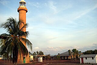
Fingal Head Light is an active lighthouse located at Fingal Head, New South Wales, Australia, a headland about 5 kilometres (3.1 mi) south of Point Danger, which marks the Queensland border.

<span class="mw-page-title-main">Kiama Light</span> Lighthouse in New South Wales, Australia

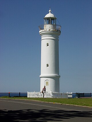
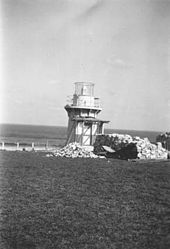
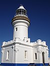
Kiama Light, also known as Kiama Harbour Light, is an active lighthouse in Kiama, New South Wales, Australia. The lighthouse is located close to the Kiama Blowhole on Blowhole Point, south of Kiama Harbour.

<span class="mw-page-title-main">Norah Head Light</span> Lighthouse in New South Wales, Australia

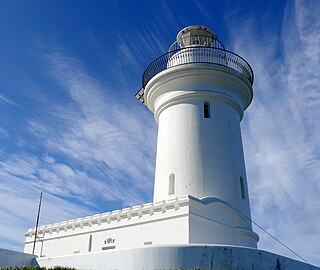
Norah Head Light is an active lighthouse located at Norah Head, a headland on the Central Coast, New South Wales, Australia, close to Toukley. It is the last lighthouse of the James Barnet style to be built, and the last staffed lighthouse constructed in New South Wales.

<span class="mw-page-title-main">South Solitary Island Light</span> Lighthouse near Coffs Harbour in New South Wales, Australia

South Solitary Island Light is an active lighthouse on South Solitary Island, an island within the Solitary Islands Marine Park, about 15 kilometres (9.3 mi) northeast of Coffs Harbour, New South Wales, Australia. The lighthouse is located at the summit of the island. It is considered the most isolated lighthouse on the New South Wales coast. It was first in New South Wales to use kerosene over colza oil, and the last to do so before converting to electric power.

<span class="mw-page-title-main">Warden Head Light</span> Lighthouse in New South Wales, Australia

Warden Head Light, also known as Ulladulla Lighthouse, is an active lighthouse on Warden Head, a headland south of Ulladulla, New South Wales, Australia, guarding the entrance to the Port of Ulladulla. It is one of only two wrought iron lighthouses in New South Wales, the other being its sibling, Wollongong Breakwater Lighthouse. It is also notable for two relocations: the tower was constructed in 1873 on the Ulladulla Breakwater, and relocated in 1889 to its current location. Its keeper's house was relocated to a different location in the 1920s.

<span class="mw-page-title-main">Clarence River Light</span> Lighthouse in New South Wales, Australia

Clarence River Light, also known as Yamba Light or Clarence Head Light, is an active lighthouse located on Pilot Hill, a hill in Wooli Park, Yamba, New South Wales, Australia, south of the entrance of Clarence River. The current lighthouse was built in 1955, replacing a previous lighthouse built in 1880. It serves as the rear range light for two different ranges.

<span class="mw-page-title-main">Cape Don Light</span> Lighthouse in Northern Territory, Australia

Cape Don Light is an active lighthouse located on Cape Don, at the tip of the Cobourg Peninsula, Northern Territory, Australia, in Garig Gunak Barlu National Park, marking the entrance to the Dundas Strait. It is Australia's northernmost traditional lighthouse. The station served on the important route to Darwin, between the peninsula and Melville Island. The tower was constructed in 1915–1917, during the "Golden Age of Australian Lighthouses" (1913–1920), and the tower was manned until 1983. During the entire period that the tower was manned it also maintained meteorological records which were well placed to assist in cyclone development tracking. The complex consists of the lighthouse, three residences and ancillary buildings.

<span class="mw-page-title-main">Booby Island Light</span> Lighthouse

Booby Island Light is an active heritage-listed lighthouse located on Booby Island in the Shire of Torres, near the tip of Cape York Peninsula, west of Prince of Wales Island, within the Endeavour Strait, Queensland, Australia. It marks the western entrance to the navigation channel through the Torres Strait. It was the last of the major lights to be constructed along the Queensland coast.

<span class="mw-page-title-main">Sandy Cape Light</span> Lighthouse

Sandy Cape Light is a heritage-listed active lighthouse located on Sandy Cape, the most northern point on K'gari, Queensland, Australia. It stands about 6 kilometres (3.7 mi) southwest of the northeastern tip of the island. It is the tallest lighthouse in Queensland. Built in 1870, it is the second major lighthouse to be built in Queensland after its formation in 1859. It is one of the first lighthouses in Australia to be constructed using bolted prefabricated segments of cast iron, and one of only two such lighthouses in Queensland, the other being its sibling, Bustard Head Light.

<span class="mw-page-title-main">Point Danger Light</span> Lighthouse in New South Wales, Australia

Point Danger Light, also known as the Captain Cook Memorial Light, is an active lighthouse located on Point Danger, a headland between Coolangatta and Tweed Heads, marking the border between Queensland and New South Wales, Australia. It lays claim to be the first lighthouse in the world to experiment with laser as a light source.

<span class="mw-page-title-main">Cape Bowling Green Light</span> Lighthouse in Queensland, Australia

Cape Bowling Green Light is an active lighthouse on Cape Bowling Green, a long headland ending in a long low sandspit, about 30 kilometres (19 mi) from Ayr, Queensland, Australia. The lighthouse is at the end of the headland, near the base of the sandspit. The first lighthouse at the location, established in 1874, was moved multiple times. It was prefabricated in Brisbane, shipped to the location, moved twice due to coastal erosion and finally transferred for display at the Australian National Maritime Museum at Darling Harbour in Sydney.

<span class="mw-page-title-main">Cleveland Point Light</span> Lighthouse in Australia

Cleveland Point Light, also known as Point Cleveland Light, is a lighthouse located on the north-eastern tip of Cleveland Point, at Cleveland, Redland City, Queensland, Australia. It overlooks Moreton Bay to the east and Raby Bay to the west. The old lighthouse was established in 1864-1865 as a wooden hexagonal tower. It is one of only two surviving lighthouses of this form, the other being Old Burnett Heads Light. A newer light, constructed of a concrete post, replaced it in 1976, and the old lighthouse was relocated a short distance away, where it stands today. The newer light was removed in 2009.

<span class="mw-page-title-main">Dent Island Light</span> Lighthouse

Dent Island Light is an active lighthouse on Dent Island, a small island off the coast of Queensland, Australia, part of the Whitsunday Group of the Whitsunday Islands. Located on the southwest tip of the island, the light guides ships navigating the Whitsunday Passage, between Whitsunday Island and the islands to the west, and marks the Dent Island Passage.

<span class="mw-page-title-main">Double Island Point Light</span> Lighthouse

Double Island Point Light is an active lighthouse located at the summit of Double Island Point, a coastal headland within the Cooloola section of the Great Sandy National Park. It is located at the southern end of Wide Bay, 70 kilometres (43 mi) north of Noosa Heads, Queensland, Australia.

References

Commons-logo.svg Media related to Ballina Lighthouse at Wikimedia Commons