Point Perpendicular Light

Last updated

Point Perpendicular Light (original)
Point Perpendicular Lighthouse.jpg
Point Perpendicular Lighthouse
Point Perpendicular Light
Location Point Perpendicular
New South Wales
Australia
Coordinates 35°05′38″S150°48′16″E / 35.09393°S 150.80458°E / -35.09393; 150.80458 Coordinates: 35°05′38″S150°48′16″E / 35.09393°S 150.80458°E / -35.09393; 150.80458
Tower
Constructed1899
Foundationsolid rock, covered flat concrete base
Constructionconcrete blocks
Automated1993
Height304 feet (93 m)
Shapecylindrical tower with balcony and lantern
Markingswhite tower, black gallery rail
Power sourcediesel  OOjs UI icon edit-ltr-progressive.svg
OperatorAustralian Maritime Safety Authority
Heritagelisted on the Commonwealth Heritage List  OOjs UI icon edit-ltr-progressive.svg
Light
Deactivated1993
Focal height70 feet (21 m)
Lens1st order Fresnel lens
Light sourcediesel generator
Intensity1,200,000 cd
Range26 nautical miles (48 km)
Characteristic Gr (3) W 20s

Point Perpendicular Light is a lighthouse located on Point Perpendicular, a point at the southern tip of the Beecroft Peninsula, in New South Wales, Australia. It marks and the northern entrance to Jervis Bay. The historic lighthouse was active from 1889 to 1993 and is still present, though its future is unclear. It is believed to be the first lighthouse in New South Wales which was built of precast concrete blocks. The light was replaced in 1993 with a skeletal tower which is active.

Contents

History

Point Perpendicular lighthouse, 1917 Point Perpendicular Lighthouse 1917.jpg
Point Perpendicular lighthouse, 1917
Plans for the lighthouse and keeper's quarters. New Lighthouse and Keepers' Quarters Point Perpendicular, Jervis Bay, 1917.jpg
Plans for the lighthouse and keeper's quarters.

Point Perpendicular Lighthouse was built to replace Cape St George Lighthouse which was inadequately located on the southern entrance to Jervis Bay, a fact which was apparent since its construction in 1860. Suggested places for replacing the light were on Bowen Island or Crocodile Head. Point Perpendicular was chosen in September 1883 by Colonial Architect James Barnet and Captain Francis Hixson of the Marine Board.

The plans for the lighthouse were signed on 18 March 1897. [1] The lighthouse was designed by James Barnet's successor, Charles Assinder Harding, who also later designed Cape Byron Light and Norah Head Light, in a style similar to Barnet's.

Tenders were called on 15 April 1897, and by September 1897 construction has started. Most of the materials were landed at Bindijine Wharf, about 8.0 kilometres (5 mi) northwest, which was constructed in 1898. Horse and cart were then used to transport them to the site.

The light was first lit on 1 May 1899. The original light source was a vaporized kerosene lamp with an intensity of 100,000 cd and a visible range of around 33 kilometres (21 mi). The apparatus installed was a massive Chance Bros. 920 millimetres (36 in) three faceted 1st order Fresnel lens, weighing 33 tonnes (32 long tons; 36 short tons), and the original light characteristic was a white flash every 20 seconds (Fl W 20s). The lens is still installed in the lighthouse.

In 1909 the light source was first upgraded, to an intensity of 222,000 cd. It was further upgraded in 1923, to an intensity of 316,000 cd.

In 1964 the light was electrified, 2 diesel engines serving as the power source.

Point Perpendicular Light (active)
Point Perpendicular skeletal.jpg
Skeletal tower that replaced Point Perpendicular Lighthouse
Point Perpendicular Light
Location Point Perpendicular
New South Wales
Australia
Coordinates 35°05′39″S150°48′16″E / 35.09423°S 150.80456°E / -35.09423; 150.80456
Tower
Constructed1993
Constructionskeletal tower
Automated1993  OOjs UI icon edit-ltr-progressive.svg
Height62 feet (19 m)
Shapesquare tower with platform and light
Markingswhite tower
Power sourcediesel  OOjs UI icon edit-ltr-progressive.svg
Operator Australian Maritime Safety Authority   OOjs UI icon edit-ltr-progressive.svg
Heritagelisted on the Commonwealth Heritage List  OOjs UI icon edit-ltr-progressive.svg
Light
Deactivated1993  OOjs UI icon edit-ltr-progressive.svg
Focal height311 feet (95 m)
Intensity1,200,000 candela  OOjs UI icon edit-ltr-progressive.svg
Range19 nautical miles (35 km)
Characteristic Fl W 10s.

On 5 July 1993 the light was shut down and replaced with a fully automated, solar powered lamp on top of a lattice skeletal tower. At that time the light was a 120 V, 1000 W quartz halogen lamp, visible to a range of 26 nautical miles (48 km; 30 mi) and the light characteristic was a group of three white flashes every twenty seconds (Gr(3) W 20s).

The future of the lighthouse is unclear. Though it was agreed upon that access to the historic lighthouse would continue, the Department of Defence, the agency governing the site, originally fenced it and access was limited. It is unclear what the exact restrictions are at this point. The structures on the location were put on sale, and the outcome of this is also unclear.

Light keepers

The first keepers were William Parker as head keeper, with William Simpson and Arthur Bailey as assistant keepers. William Parker was previously the light keeper of Cape St George Lighthouse, and Arthur Bailey was the son of Edward Bailey, the late keeper of Cape St George Lighthouse.

The last keeper was John Hampson.

Re-lightings

The light was relit twice to celebrate important occasions.

The first occasion was the lighthouse centenary, which was on 1 May 1999, though celebrations were postponed until October 1999 to be incorporated in the Currarong Seafare Festival. Celebrations included a ball and an art and photography competition on 15 October 1999. This was followed by on-site celebrations on 16 October, including tours, a naval display, a market day, children's activities and finally, the lighthouse was lit. The light remained lit between 6pm (which was the time of dusk, the light was set to switch itself automatically) and 11pm. The new light was shut down for the period. [2]

The light was re-lit once more on 20–21 August 2005 for the International Lighthouse & Lightship Weekend 2005. [3]

Structures

A view of the lighthouse and the keeper's residence, close to their construction Point Perpendicular Lighthouse and Keeper's quarters c1899.jpg
A view of the lighthouse and the keeper's residence, close to their construction

The tower is made from concrete blocks which were made on the ground, lifted into position, and then cement-rendered inside and outside, a technique which eases building as it does not require formworks or scaffolding. The block varied in size and shape, but were mostly 12 inches (300 mm) high.

The tower is circular, with an internal diameter of 11 feet 9 inches (3.58 m). It is 44 feet (13 m) to the balcony, divided into three stories by concrete floors paved with black and white tiles, staircases 3 feet (0.91 m) wide leading from one floor to the next, with a handrail of 2 inches (51 mm) heavy brass tubing. On top of the tower is a bluestone gallery and balcony with black railings.

The tower is painted white with a blue trim on the bottom.

Above the main door there is a glass window displaying a Waratah, the state flower of New South Wales, and the construction date.

The tower is attached to a one-storey lighthouse keeper's house made from the same concrete blocks, painted likewise white with a blue trim on the bottom.

The keepers' residences are located about 70 feet (21 m) south of the lighthouse. Originally each had an underground water tank of 6,500 imperial gallons (30,000 l; 7,800 US gal), kept filled by rain from the roofs.

Also present is a structure originally serving as a two-stall stable and coach house, which was later used to house the generators.

Site operation and visiting

The light is operated by Australian Maritime Safety Authority. The site is operated by the Department of Defence, and used for gunnery practice about 100 days a year, in which access is limited.

See also

Notes

  1. "DTD Point Perpendicular Lighthouse". dtd.com.au. Retrieved 6 September 2010.
  2. Deborah Taylor (November 1999). "Pt Perpendicular Expedition Report: (Part 1 of 2)". Lighthouses of Australia Inc Bulletin.
  3. "International Lighthouse Weekend 2005". justimagine.com.au. Retrieved 6 September 2010.

Related Research Articles

<span class="mw-page-title-main">Macquarie Lighthouse</span> Lighthouse in New South Wales, Australia

The Macquarie Lighthouse, also known as South Head Upper Light, is the first, and is the longest serving, lighthouse site in Australia. It is located on Dunbar Head, on Old South Head Road, Vaucluse in the Municipality of Woollahra local government area of New South Wales, Australia. The lighthouse is situated approximately 2 kilometres (1 mi) south of South Head near the entrance to Sydney Harbour. There has been a navigational aid in this vicinity since 1791 and a lighthouse near the present site since 1818. The current heritage-listed lighthouse was completed in 1883. The lighthouse and associated buildings were designed by James Barnet and built from 1881 to 1883.

<span class="mw-page-title-main">Cape St George Lighthouse</span> Lighthouse

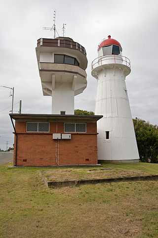
Cape St George Lighthouse was a lighthouse that stood near Jervis Bay Village, Jervis Bay Territory, Australia. It was located about 3 kilometres (1.9 mi) south of the southern entrance to Jervis Bay. Constructed in 1860 it was active until 1889. The tower was destroyed between 1917–1922 to avoid confusion in daylight. The ruins remain and are listed on the Commonwealth Heritage List.

<span class="mw-page-title-main">Green Cape Lighthouse</span> Lighthouse in New South Wales, Australia

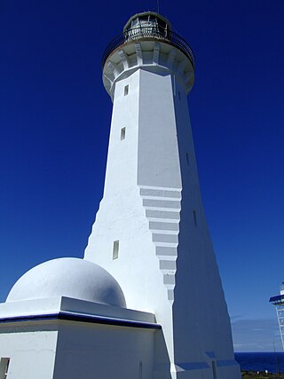
The Green Cape Lighthouse is a heritage-listed lighthouse located at the tip of Green Cape, a headland forming the northern boundary of Disaster Bay, in southern New South Wales, Australia. It is the southernmost lighthouse in New South Wales and Australia's first lighthouse built in concrete. At 29 metres (95 ft) it is also the tallest lighthouse in New South Wales. It marks Green Cape on the northerly shore-hugging sailing course.

<span class="mw-page-title-main">Smoky Cape Lighthouse</span> Lighthouse in New South Wales, Australia

Smoky Cape Lighthouse is a heritage-listed active lighthouse located on Smoky Cape, a headland in Arakoon east of the town of South West Rocks, Kempsey Shire, New South Wales, Australia, and within the Hat Head National Park. It directs boats towards the entrance to the Macleay River, which is located just to the north of the lighthouse.

<span class="mw-page-title-main">Cape Byron Light</span> Lighthouse in New South Wales, Australia

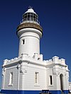
Cape Byron Light, also called Cape Byron Lightstation, is an active heritage-listed lighthouse and now interpretative centre, interpretative space, maritime museum, administration office, retail building, accommodation, tourist attraction and visitor attraction located at Lighthouse Road, Byron Bay, Cape Byron, Byron Shire, New South Wales, Australia. It was designed by Charles Harding and Cecil W. Darley and built from 1899 to 1901 by Messrs Mitchell & King. It is also known as Cape Byron Lightstation, Byron Bay Lighthouse, Cape Byron Headlan and Cape Byron Headland Reserve. The property is owned by NSW National Parks & Wildlife Service.

<span class="mw-page-title-main">Crowdy Head Light</span> Lighthouse in New South Wales, Australia

Crowdy Head Light is an active lighthouse located at Crowdy Head, a headland between Forster and Port Macquarie, New South Wales, Australia. It is registered with the Register of the National Estate.

<span class="mw-page-title-main">Fingal Head Light</span> Lighthouse in New South Wales, Australia

Fingal Head Light is an active lighthouse located at Fingal Head, New South Wales, Australia, a headland about 5 kilometres (3.1 mi) south of Point Danger, which marks the Queensland border.

<span class="mw-page-title-main">Kiama Light</span> Lighthouse in New South Wales, Australia

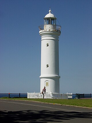
Kiama Light, also known as Kiama Harbour Light, is an active lighthouse in Kiama, New South Wales, Australia. The lighthouse is located close to the Kiama Blowhole on Blowhole Point, south of Kiama Harbour.

<span class="mw-page-title-main">Norah Head Light</span> Lighthouse in New South Wales, Australia

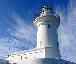
Norah Head Light is an active lighthouse located at Norah Head, a headland on the Central Coast, New South Wales, Australia, close to Toukley. It is the last lighthouse of the James Barnet style to be built, and the last staffed lighthouse constructed in New South Wales.

<span class="mw-page-title-main">Barrenjoey Head Lighthouse</span> Lighthouse in New South Wales, Australia

The Barrenjoey Head Lighthouse is a heritage-listed lighthouse at Barrenjoey Headland, Palm Beach, Northern Beaches Council, New South Wales, Australia. It was designed by James Barnet, the New South Wales Colonial Architect and built by Isaac Banks. It is also known as Barrenjoey Head Lightstation. The property is owned by Office of Environment and Heritage, an agency of the Government of New South Wales. The lightstation was added to the New South Wales State Heritage Register on 2 April 1999.

<span class="mw-page-title-main">Point Stephens Light</span> Lighthouse in New South Wales, Australia

The Point Stephens Light is a heritage-listed active lighthouse located on Point Stephens, a point on an unnamed headland at the east of Fingal Bay, 4.25 km (2.64 mi) south of the entrance of Port Stephens, New South Wales, Australia. The light serves to assist vessels entering Port Stephens. It is considered an endangered lighthouse due to remote location and old age.

<span class="mw-page-title-main">South Solitary Island Light</span> Lighthouse near Coffs Harbour in New South Wales, Australia

South Solitary Island Light is an active lighthouse on South Solitary Island, an island within the Solitary Islands Marine Park, about 15 kilometres (9.3 mi) northeast of Coffs Harbour, New South Wales, Australia. The lighthouse is located at the summit of the island. It is considered the most isolated lighthouse on the New South Wales coast. It was first in New South Wales to use kerosene over colza oil, and the last to do so before converting to electric power.

<span class="mw-page-title-main">Sugarloaf Point Light</span> Lighthouse in New South Wales, Australia

Sugarloaf Point Light, also known as Seal Rocks Lighthouse, is an active lighthouse located on Sugarloaf Point, a point about 3 kilometres (1.9 mi) southeast of Seal Rocks, Mid-Coast Council, New South Wales, Australia. It guards Seal Rocks, a treacherous rock formation to the south. It is the first lighthouse designed by James Barnet, and built from 1874 to 1875 by John McLeod. It is also one of only two towers in Australia with an external stairway. It is also known as Sugarloaf Point Lightstation Group, Seal Rocks Lightstation Complex and Sugarloaf Point Lighthouse. The property is owned by National Parks and Wildlife Service. It was added to the Commonwealth Heritage List on 22 June 2004; on the New South Wales State Heritage Register on 22 February 2019; and on the Register of the National Estate on 10 April 1989.

<span class="mw-page-title-main">Warden Head Light</span> Lighthouse in New South Wales, Australia

Warden Head Light, also known as Ulladulla Lighthouse, is an active lighthouse on Warden Head, a headland south of Ulladulla, New South Wales, Australia, guarding the entrance to the Port of Ulladulla. It is one of only two wrought iron lighthouses in New South Wales, the other being its sibling, Wollongong Breakwater Lighthouse. It is also notable for two relocations: the tower was constructed in 1873 on the Ulladulla Breakwater, and relocated in 1889 to its current location. Its keeper's house was relocated to a different location in the 1920s.

<span class="mw-page-title-main">Booby Island Light</span> Lighthouse

Booby Island Light is an active heritage-listed lighthouse located on Booby Island in the Shire of Torres, near the tip of Cape York Peninsula, west of Prince of Wales Island, within the Endeavour Strait, Queensland, Australia. It marks the western entrance to the navigation channel through the Torres Strait. It was the last of the major lights to be constructed along the Queensland coast.

<span class="mw-page-title-main">Cape Moreton Light</span> Lighthouse in Queensland, Australia

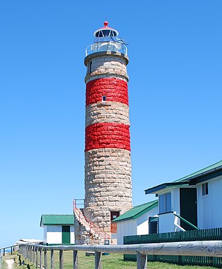
Cape Moreton Light, also listed as North Point Range Rear Light, is a heritage-listed active lighthouse located on Cape Moreton, a rocky headland located at the north eastern tip of Moreton Island, a large sand island on the eastern side of Moreton Bay, on the coast of South East Queensland, Australia. It marks the northern entrance to Moreton Bay and Brisbane and also serves as the rear light for the North Point Range. With its two distinctive red bands, it also serves as a daymark. It is the oldest lighthouse in Queensland, and the only one to be built by the New South Wales Government before the separation of Queensland, which took place in 1859. It is also the only lighthouse in Queensland to be built of stone.

<span class="mw-page-title-main">Double Island Point Light</span> Lighthouse

Double Island Point Light is an active lighthouse located at the summit of Double Island Point, a coastal headland within the Cooloola section of the Great Sandy National Park. It is located at the southern end of Wide Bay, 70 kilometres (43 mi) north of Noosa Heads, Queensland, Australia.

<span class="mw-page-title-main">Needles Lighthouse</span> Lighthouse

The Needles Lighthouse is an active 19th century lighthouse on the outermost of the chalk rocks at The Needles on the Isle of Wight in the United Kingdom, near sea level. Designed by James Walker, for Trinity House at a cost of £20,000. It was completed in 1859 from granite blocks, stands 33.25 metres (109.1 ft) high and is a circular tower with straight sides. It replaced an earlier light tower on top of a cliff overhanging Scratchell's Bay, which was first lit on 29 September 1786.

<span class="mw-page-title-main">Norah Head Lightstation Precinct</span> Lighthouse in New South Wales, Australia

Norah Head Lightstation Precinct is a heritage-listed former lighthouse precinct located at Bush Street, Norah Head in the Central Coast local government area of New South Wales, Australia. The Norah Head lighthouse and associated buildings were designed by Cecil W. Darley and built in 1903. The precinct was added to the New South Wales State Heritage Register on 13 April 2007.

References

Commons-logo.svg Media related to Point Perpendicular Lighthouse at Wikimedia Commons