Palm Beach is a suburb in the Northern Beaches region of Sydney, in the state of New South Wales, Australia. Palm Beach is located 41 kilometres (25 mi) north of the Sydney central business district, in the local government area of Northern Beaches Council. Palm Beach sits on a peninsula at the end of Barrenjoey Road, between Pittwater and Broken Bay. The population of Palm Beach was 1,593 as at the 2016 census.

Tweed Heads is a town in New South Wales. It is located on the Tweed River in north-eastern New South Wales, Australia, in Tweed Shire, next to the border with Queensland and adjacent to its "twin town" of Coolangatta, which is a suburb of the Gold Coast. It is often referred to as a town where people can change time zones – even celebrate New Year twice within an hour – simply by crossing the street, due to its proximity to the Queensland border, and the fact that New South Wales observes daylight saving whereas Queensland does not.

Coolangatta is a coastal suburb in the City of Gold Coast, Queensland, Australia. It is the Gold Coast's southernmost suburb and it borders New South Wales. In the 2016 census, Coolangatta had a population of 5,948 people.

Little Bay is a suburb in south-eastern Sydney, in the state of New South Wales, Australia. Little Bay is located 14 kilometres south-east of the Sydney central business district and is part of the local government area of the City of Randwick.

Tamarama is a beachside suburb, eastern suburb of Sydney, in the state of New South Wales, Australia. Tamarama is 6 kilometres east of the Sydney central business district, in the local government area of Waverley Council.

Fingal Bay is the easternmost suburb of the Port Stephens local government area in the Hunter Region of New South Wales, Australia. The only population centre is the township of the same name, which itself is named after the adjacent, small, semi-circular bay. At the 2021 census, the population of the town was 1,635.
Nelson Bay is a significant township of the Port Stephens local government area in the Hunter Region of New South Wales, Australia. It is located on a bay of the same name on the southern shore of Port Stephens about 60 kilometres (37 mi) by road north-east of Newcastle, its nearest rail link. At the 2021 census, Nelson Bay had a population of 6,141.

Forster is a coastal town in the Mid North Coast region of New South Wales, Australia, in the Mid-Coast Council LGA, about 308 km north-north-east of Sydney. It is immediately adjacent to its twin, Tuncurry, which is the smaller of the two towns. Forster is known for its stunning waters and Manning Valley beauty.

Bilinga is a southern coastal suburb in the City of Gold Coast, Queensland, Australia. In the 2016 census, Bilinga had a population of 1,804 people. It is on the border with New South Wales.

The Westpac Lifesaver Rescue Helicopter Service is a helicopter surf lifesaving service that operates in Australia.

Surf Life Saving Australia (SLSA) is an Australian not-for-profit community organisation that promotes water safety and provides surf rescue services.

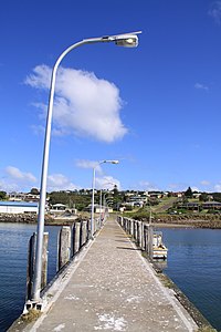
One Mile is a suburb of the Port Stephens local government area in the Hunter Region of New South Wales, Australia. The Worimi people are the traditional owners of the Port Stephens area. The suburb is semi-rural with a small urban settlement, several eco-resorts and back-packer accommodations to the west of Gan Gan Road. On the beach side there is a residential land-lease community and three tourist parks. The parks, two of which have licensed restaurants, are positioned to provide quick access to the suburb's two beaches. Since late 2017 Port Stephens Koala Hospital has been operating in the grounds of Treescape resort.
Jones Beach, also known as Boyds Beach, is a beach on the south-eastern coast of Australia, facing the Tasman Sea. The beach is east of the settlement of Kiama Downs and about 2 kilometres (1.2 mi) south by east of the settlement of Minnamurra in the Illawarra and South Coast regions of New South Wales.

Bar Beach is an inner city suburb of Newcastle, New South Wales, Australia, located 1.6 km (1.0 mi) southwest of Newcastle's central business district. The suburb is named for the beach that extends along its eastern border.
Harrington is a small village located on the northern entrance of the Manning River in New South Wales, Australia. It was established in 1853 and proclaimed a village on 26 September 1896. It is 15 km north-east of Taree on the Mid North Coast, and 335 kilometres (208 mi) north east of the state capital, Sydney. At the 2021 census, Harrington had a population of 3,381. It was named after the Earl of Harrington by the explorer, John Oxley.

Tacking Point Lighthouse is Australia's thirteenth oldest lighthouse. It was built on a rocky headland about 8 kilometres south of Port Macquarie in 1879 by Shepherd and Joseph William Mortley, to a design by the New South Wales Colonial Architect, James Barnet. It is operated by the Australian Maritime Safety Authority and is classified by the National Trust of Australia (NSW).
The club was founded in 1903 and the movement has since spread to other parts of New South Wales and the rest of the country. The club rests on indigenous land and whilst there is no clear evidence for the name or names of the Eora people who lived in what is now the Waverley area, most sources agree on the Cadigal, but some sources name the Biddigal and Birrabirragal bands as well.

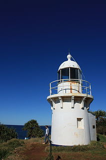
Crowdy Head Light is an active lighthouse located at Crowdy Head, a headland between Forster and Port Macquarie, New South Wales, Australia. It is registered with the Register of the National Estate.
Fingal Head Light is an active lighthouse located at Fingal Head, New South Wales, Australia, a headland about 5 kilometres (3.1 mi) south of Point Danger, which marks the Queensland border.
The Bondi Surf Bathers' Life Saving Club is Australia's oldest Surf Life Saving Club, founded in 1907. The club was officially established on 21 February 1907 at the Royal Hotel in Bondi Beach, Sydney, New South Wales. The clubs aim is to ensure "No Lives Lost" at Bondi Beach and is a volunteer organisation that patrols Bondi Beach from October to April every year.