Mid-Coast Council

Last updated

MidCoast Council
New South Wales
Mid-Coast LGA NSW.png
MidCoast Council in New South Wales
Coordinates 32°00′S151°58′E / 32.000°S 151.967°E / -32.000; 151.967 Coordinates: 32°00′S151°58′E / 32.000°S 151.967°E / -32.000; 151.967
Population
  • 90,504 (2016) [1]
  • 93,288 (2018 est.) [2]
 • Density9.0027/km2 (23.3168/sq mi)
Established12 May 2016 (2016-05-12) [1]
Area10,053 km2 (3,881.5 sq mi) [1]
MayorClaire Pontin
Region Mid North Coast
State electorate(s)
Federal division(s) Lyne
Mid Coast Council Logo.jpg
Website MidCoast Council
LGAs around MidCoast Council:
Walcha
Port Macquarie-Hastings
Port Macquarie-Hastings Port Macquarie-Hastings
Dungog MidCoast Council Tasman Sea
Port Stephens Port Stephens Tasman Sea

MidCoast Council is a local government area (LGA) located in the Mid North Coast region of New South Wales, Australia. The council was formed on 12 May 2016 through a merger of the Gloucester Shire, Great Lakes and City of Greater Taree councils. [1]

Contents

The council comprises an area of 10,053 square kilometres (3,881 sq mi) and occupies the southern portion of the Mid North Coast of New South Wales stretching 190 km (118 mi) between the coastal towns of Hawks Nest and Tea Gardens and northwards to Crowdy Bay National Park. The council region includes the three great lakes, the coastal towns of Seal Rocks, Forster, Taree, and onto Crowdy Head north of Harrington. The LGA extends inland to the Barrington Tops National Park west of Gloucester, plus Stroud, Bulahdelah and Wingham. It includes the Manning River and valley adjoining the Three Brothers mountains. At the time of its establishment the council had an estimated population of 90,504. [1]

The Mayor of the MidCoast Council is Councillor Claire Pontin, who was elected on 12 January 2022. [1]

Towns and localities

The following towns and localities are located within Mid–Coast Council:

Heritage listings

MidCoast Council has a number of heritage-listed sites, including:

Demographics

The population for the predecessor councils was estimated in 2015 as: [4]

Council

MidCoast Council is composed of eleven councillors elected proportionally in a single ward. All councillors were elected to a fixed three-year term of office on 4 December 2021. The positions of Mayor and Deputy Mayor are chosen by councillors.

PartyCouncillors
  Independents 2
  Liberal 2
 Peter Epov Group2
 Alan Tickle Group1
 Bell Team Independents1
  Labor 1
  The Greens 1
 Your Local Independents1
Total11

The current Council, elected in 2021, in order of election, is: [5] [6] [7]

CouncillorPartyNotes
 Dheera Smith The Greens
 Paul SandilandsYour Local Independents
 Jeremy MillerIndependent
 Peter HowardPeter Epov Group
 Peter EpovPeter Epov Group
 Troy Fowler Liberal Party of Australia
 Kathryn BellBell Team Independents
 Claire Pontin Australian Labor Party Mayor
 David West Liberal Party of Australia
 Katheryn SmithIndependent
 Alan TickleAlan Tickle GroupDeputy Mayor

Related Research Articles

<span class="mw-page-title-main">Taree</span> Town in New South Wales, Australia

Taree is a town on the Mid North Coast, New South Wales, Australia. Taree and nearby Cundletown were settled in 1831 by William Wynter. Since then Taree has grown to a population of 26,381, and is the centre of a significant agricultural district. It is 16 km from the Tasman Sea coast, and 317 km north of Sydney. Taree can be reached by train via the North Coast Railway, and by the Pacific Highway. Taree railway station is on the North Coast line of the NSW TrainLink network. It is serviced by six NSW TrainLink trains daily: three heading to Sydney, another three heading North to Grafton, Casino or Brisbane. Taree is within the local government area of Mid-Coast Council, the state electorate of Myall Lakes and the Federal electorate of Lyne.

<span class="mw-page-title-main">Myall Lakes</span> Lakes in New South Wales, Australia

Myall Lakes, a series of fresh water lakes protected under the Ramsar Convention, are located within the Mid-Coast Council local government area in the Mid North Coast region of New South Wales, Australia.

<span class="mw-page-title-main">Port Stephens (New South Wales)</span> Estuarine lake in New South Wales, Australia

Port Stephens, an open youthful tide-dominated drowned-valley estuary, is a large natural harbour of approximately 134 square kilometres (52 sq mi) located in the Hunter Region of New South Wales, Australia.

<span class="mw-page-title-main">Mid North Coast</span> Region in New South Wales, Australia

The Mid North Coast is a country region in the north-east of the state of New South Wales, Australia. The region covers the mid northern coast of the state, beginning from Port Stephens 160 km (99 mi) north of Sydney, and extending as far north as Woolgoolga, 562 km (349 mi) north of Sydney, a distance of roughly 400 km (250 mi).

<span class="mw-page-title-main">Manning River</span> River in New South Wales, Australia

Manning River, an open and trained mature wave dominated barrier estuary, is located in the Northern Tablelands and Mid North Coast districts of New South Wales, Australia. It is the only double delta river in the southern hemisphere in which there are two permanent entrances to the river, one at Old Bar and another at Harrington, and is famously one of only two rivers in the world to have permanent multiple entrances with the other being the Nile river in Egypt.

<span class="mw-page-title-main">Bucketts Way</span>

(The) Bucketts Way is a 151-kilometre (94 mi) rural road that links Gloucester to Taree and Raymond Terrace, in New South Wales, Australia. A former alignment of Pacific Highway, it was later named after the Bucketts Mountains, a prominent mountain range near Gloucester. The entire route is designated as Tourist Route 2.

<span class="mw-page-title-main">St Andrew's Presbyterian Church, Wingham</span> Church in New South Wales, Australia

St Andrew's Presbyterian Church is a Presbyterian church at 32 Moon Street, Wingham, New South Wales. The church is the main centre of the Wingham and Upper Manning Parish. The other centre is St Thomas' Presbyterian Church, Krambach.

<span class="mw-page-title-main">Electoral district of Myall Lakes</span> State electoral district of New South Wales, Australia

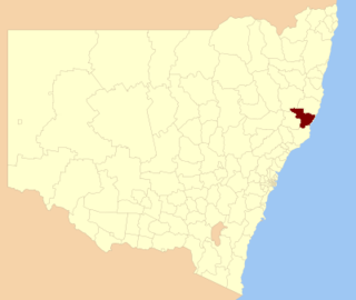
Myall Lakes is an electoral district of the Legislative Assembly in the Australian state of New South Wales. It is represented by Stephen Bromhead of The Nationals.

<span class="mw-page-title-main">City of Greater Taree</span> Local government area in New South Wales, Australia

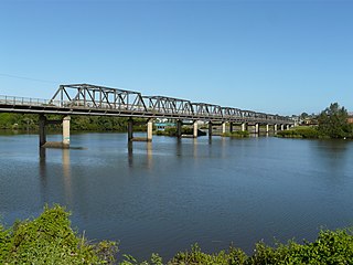
The Greater Taree City Council (GTCC) was a local government area on the Mid North Coast of New South Wales, Australia, until 12 May 2016 when it was amalgamated to form part of the Mid-Coast Council. It was originally formed in 1981 from the Manning Shire, and the Taree and Wingham Municipal Councils. The council was centred on Taree, located adjacent to the Manning River, the Pacific Highway and the North Coast railway line.

<span class="mw-page-title-main">Great Lakes Council</span> Local government area in New South Wales, Australia

Great Lakes Council was a local government area in the Mid North Coast region of New South Wales, Australia. The area is situated adjacent to the shores of Port Stephens, Myall Lakes and Wallis Lake and the Pacific Highway and the Lakes Way. On 12 May 2016 the council was dissolved and the area included in the Mid-Coast Council, along with the City of Greater Taree and Gloucester Shire.

<span class="mw-page-title-main">Bulahdelah, New South Wales</span> Town in New South Wales, Australia

Bulahdelah is a town and locality in the Hunter/Mid North Coast region of New South Wales, Australia in the Mid-Coast Council local government area. At the 2016 census, the locality had a population of 1,424. The main population centre, where 69% of the area's population lived in 2006, is the town of Bulahdelah.

<span class="mw-page-title-main">Myall River</span> River in New South Wales, Australia

Myall River, an open semi-mature brackish freshwater barrier estuary of the Mid-Coast Council system, is located in the Mid North Coast region of New South Wales, Australia.

<span class="mw-page-title-main">Gloucester Shire</span> Former local government area in New South Wales, Australia

Gloucester Shire was a local government area in the Mid North Coast and Upper Hunter regions of New South Wales, Australia. The Shire was situated adjacent to the Bucketts Way and the North Coast railway line.

The Worimi people are Aboriginal Australians from the eastern Port Stephens and Great Lakes regions of coastal New South Wales, Australia. Before contact with settlers, their people extended from Port Stephens in the south to Forster/Tuncurry in the north and as far west as Gloucester.

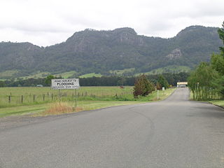
Monkerai is a large rural area in the hills in the land between Dungog and Gloucester in Mid-Coast Council, in the Hunter Region, New South Wales, Australia.

The Crawford River, a perennial river of the Mid-Coast Council system, is located in the Mid North Coast region of New South Wales, Australia.

Mammy Johnsons River, a mostly perennial river of the Mid-Coast Council system, is located in the Mid North Coast and Upper Hunter regions of New South Wales, Australia.

The Branch River, a watercourse of the Mid-Coast Council system, is located in the Mid North Coast and Upper Hunter regions of New South Wales, Australia.

Wards River, a mostly perennial river of the Mid-Coast Council system, is located in the Mid North Coast and Upper Hunter regions of New South Wales, Australia.

<span class="mw-page-title-main">Wingham Memorial Town Hall</span> Historic site in New South Wales, Australia

Wingham Memorial Town Hall is a heritage-listed town hall at 52 Farquhar Street, Wingham, Mid-Coast Council, New South Wales, Australia. It was designed by James T. Chambers and built from 1922 to 1924. It is also known as Wingham Town Hall and Wingham Council Chambers. The property is owned by Mid-Coast Council. It was added to the New South Wales State Heritage Register on 8 April 2016.

References

  1. 1 2 3 4 5 6 "Mid-Coast Council". Stronger Councils. Government of New South Wales. 12 May 2016. Retrieved 24 May 2016.
  2. "3218.0 – Regional Population Growth, Australia, 2017-18". Australian Bureau of Statistics. 27 March 2019. Retrieved 27 March 2019. Estimated resident population (ERP) at 30 June 2018.
  3. "High Conservation Value Old Growth forest". New South Wales State Heritage Register . Department of Planning and Environment. H01487. Retrieved 18 May 2018. CC-BY icon.svg Text is licensed by State of New South Wales (Department of Planning and Environment) under CC-BY 4.0 licence .
  4. "Regional Population Growth, Australia. Population Estimates by Local Government Area (ASGS 2015), 2005 to 2015 Table 1. Estimated Resident Population, Local Government Areas, New South Wales". 30 March 2016. Retrieved 21 May 2016.
  5. "Mid-Coast Council - Summary of First Preference Votes for each Candidate". Local Government Election 2017. Electoral Commission of New South Wales. 18 September 2017. Retrieved 19 November 2021.
  6. "Mid-Coast - 2017 NSW Local Government Elections - ABC News (Australian Broadcasting Corporation)". ABC News. Retrieved 19 November 2021.
  7. "20211129-LG-Groups-of-Candidates.pdf" (PDF).