City of Dubbo

Last updated

City of Dubbo
New South Wales
Dubbo LGA NSW.png
Location in New South Wales
Coordinates 32°15′S148°36′E / 32.250°S 148.600°E / -32.250; 148.600
Population41,211 (2011 census) [1]
 • Density12.0324/km2 (31.164/sq mi)
Established1872
Abolished12 May 2016 (2016-05-12)
Area3,425 km2 (1,322.4 sq mi)
Council seat Dubbo
Region Orana
State electorate(s) Dubbo
Federal division(s) Parkes
Website City of Dubbo
LGAs around City of Dubbo:
Narromine Gilgandra Warrumbungle
Narromine City of Dubbo Wellington
Parkes Parkes Wellington

The City of Dubbo was a local government area in the Orana region of New South Wales, Australia. The former area is located adjacent to the Mitchell, Newell, and the Golden highways, the Main Western railway line, and the Macquarie River.

Contents

A 2015 review of local government boundaries recommended that the City of Dubbo merge with the Wellington Council to form a new council with an area of 7,536 square kilometres (2,910 sq mi) and support a population of approximately 51,000. [2] Following an independent review, on 12 May 2016 the Minister for Local Government announced the dissolution of the Dubbo City Council and the Wellington Council, together with the establishment of the Western Plains Regional Council with immediate effect. [3]

The last mayor of the City of Dubbo was Clr. Mathew Dickerson, an independent politician.

The last deputy mayor of the City of Dubbo was Clr. Ben Shields, an unaligned politician. Clr. Ben Shields was elected in 1st position at the 2012 and 2008 Dubbo City Council elections.

The largest population centre in the former area is the regional city of Dubbo. The local government area also included the villages of Eumungerie, Mogriguy, Brocklehurst, Wongarbon, Toongi, and Rawsonville. [4]

History

The Dubbo local government area came into being on 19 February 1872, when the Municipal District of Dubbo was approved by the Colonial Secretary. The first six aldermen were elected into office on 22 April 1872 with 82 votes being cast for a wide field of candidates. [5] James Samuels was elected mayor at the first council meeting and remained mayor for 3 years. [6]

Talbragar Shire was amalgamated with the Dubbo City Council on 1 April 1980. At that time the area of the city was 3,321 square kilometres (1,282 sq mi); and with a population estimated at 29,000. [5]

Council

Current composition and election method

Prior to its dissolution, the Dubbo City Council was composed of eleven councillors elected proportionally as a single ward. All Councillors were elected for a fixed four-year term of office. The mayor was elected by the councillors at the first meeting of the council. The most recent election was held on 8 September 2012, and the makeup of the former council was as follows: [7]

PartyCouncillors
  Independents and Unaligned11
Total11

The last Council, elected in 2012 and dissolved in 2016, in order of election, was: [7]

CouncillorPartyNotes
 Ben ShieldsUnalignedDeputy Mayor [8]
 Mathew Dickerson Independent Mayor [8]
 John WalkomUnaligned
 Bill KellyIndependent
 Greg MohrUnalignedElected on Ben Shields ticket
 Allan SmithIndependent
 Kevin ParkerUnaligned
 Tina ReynoldsIndependent
 Greg MathewsUnaligned
 Lyn GriffithsIndependent
 Rod TowneyIndependent

The former Dubbo City Council staffed around 350 permanent employees, and was responsible for the city and surrounding areas. The Civic Administration Building of the former council is located on the corner of Darling and Church Streets and now has a "One Stop Shop" for all customers of the former council.

Industry

As a regional centre, the City of Dubbo provided services far beyond its own population base. It served 130,000 people, and one third of the geographic area of New South Wales. [4] The main industry sectors represented in the City of Dubbo were retail, health, manufacturing, transport, tourism, education, construction, business services, agriculture, and government services. [4]

Sister cities

The City of Dubbo had four sister cities: [9]

Related Research Articles

<span class="mw-page-title-main">City of Queanbeyan</span> Former local government area in New South Wales, Australia

Queanbeyan City was a local government area located in south eastern New South Wales, Australia. The former area is located adjacent to Canberra and the Australian Capital Territory, the Queanbeyan River, the Molonglo River, the Kings Highway and the Sydney-Canberra railway.

<span class="mw-page-title-main">Jerilderie Shire</span> Former local government area in New South Wales, Australia

Jerilderie Shire was a local government area in the Riverina region of southern New South Wales, Australia. The Shire was located adjacent to the Newell Highway. The Shire was declared in 1918 after the amalgamation of the former Municipality of Jerilderie and Wunnamurra Shire. It was dissolved in 2016 after its amalgamation with Murrumbidgee Shire to create Murrumbidgee Council

<span class="mw-page-title-main">Murrumbidgee Shire</span> Former local government area in New South Wales, Australia

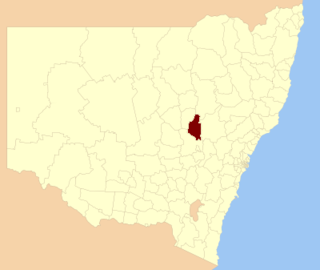
Murrumbidgee Shire was a local government area in the Riverina region of south western New South Wales, Australia. The Shire was located adjacent to the Murrumbidgee River and the Newell Highway.

<span class="mw-page-title-main">City of Ryde</span> Local government area in New South Wales, Australia

The City of Ryde is a local government area in the Northern Sydney region, in New South Wales, Australia. It was first established as the Municipal District of Ryde in 1870, became a municipality in 1906 and was proclaimed as the City of Ryde in 1992.

<span class="mw-page-title-main">Palerang Council</span> Former local government area in New South Wales, Australia

The Palerang Council was a local government area located in the Southern Tablelands region of New South Wales, Australia. On 12 May 2016 the Minister for Local Government announced dissolution of the Palerang Council with immediate effect. Together with Queanbeyan City the combined council areas were merged to establish the Queanbeyan-Palerang Regional Council. Both councils had opposed the amalgamation. Elections for the new Council area were held in September 2017. The former mayor of Queanbeyan City Council was appointed by the New South Wales Government as administrator until that date.

<span class="mw-page-title-main">Cooma-Monaro Shire</span> Former local government area in New South Wales, Australia

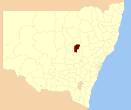
Cooma-Monaro Shire was a local government area located in the Monaro region of southern New South Wales, Australia. The area was named after the former Cooma Municipality and the former Monaro Shire, that were amalgamated to create it. The Municipality of Cooma was established in 1879, and the Monaro Shire was one of several shires established in 1906. The Monaro Shire and Cooma Municipal Council amalgamated in 1981. On 11 February 2004, Cooma-Monaro Shire absorbed a small part of the former Yarrowlumla Shire, near Michelago.

<span class="mw-page-title-main">Murray Shire</span> Former local government area in New South Wales, Australia

Murray Shire was a local government area in the Riverina region of south western New South Wales, Australia. It included the towns of Moama and Mathoura. It was abolished on 12 May 2016 and its area merged with the Wakool Shire to establish the Murray River Council.

<span class="mw-page-title-main">Mid-Western Regional Council</span> Local government area in New South Wales, Australia

The Mid-Western Regional Council is a local government area in the Central West region of New South Wales, Australia. The area is located adjacent to the Castlereagh Highway that passes through the middle of the area in an approximate southeast–northwest direction.

<span class="mw-page-title-main">Wakool Shire</span> Former local government area in New South Wales, Australia

Wakool Shire was a local government area in the Riverina region of New South Wales, Australia. The Shire was located between the Murray River and the Murrumbidgee River and adjacent to the Sturt Highway. Towns in the Shire are Barham, Moulamein, Tooleybuc, Wakool and Koraleigh.

<span class="mw-page-title-main">Armidale Dumaresq Shire</span> Former local government area in New South Wales, Australia

The Armidale Dumaresq Council was a local government area in the New England and Northern Tablelands regions of New South Wales, Australia. This area was formed in 2000 from the merger of the original City of Armidale with the surrounding Dumaresq Shire and abolished on 12 May 2016, where the council, together with Guyra Shire, was subsumed into the Armidale Regional Council with immediate effect.

<span class="mw-page-title-main">Bathurst Regional Council</span> Local government area in New South Wales, Australia

Bathurst Regional Council is a local government area in the Central West region of New South Wales, Australia. The area is located adjacent to the Great Western Highway, Mid-Western Highway, Mitchell Highway and the Main Western railway line. At the 2016 census, the Bathurst Region had a population of 41,300.

<span class="mw-page-title-main">Blayney Shire</span> Local government area in New South Wales, Australia

Blayney Shire is a local government area in the Central West region of New South Wales, Australia. The Shire is located adjacent to the Mid-Western Highway and the Main Western railway line, and is centred on the town of Blayney.

<span class="mw-page-title-main">Bombala Shire</span> Former local government area in New South Wales, Australia

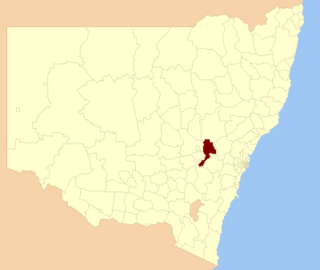
The Bombala Shire was a local government area in the Monaro region of south-eastern New South Wales, Australia. The Shire includes the town of Bombala, the villages of Delegate, Cathcart, Bibbenluke and the localities of Ando, Bungarby, Craigie, Mila, Rockton and Creewah. Bombala Shire was formed on 1 October 1977 by the amalgamation of the Municipality of Bombala and Bibbenluke Shire.

<span class="mw-page-title-main">City of Griffith</span> Local government area in New South Wales, Australia

The City of Griffith is a local government area in the Riverina region of south-western New South Wales, Australia. The area comprises 1,640 square kilometres (630 sq mi) and is located in the Murrumbidgee Irrigation Area and on Kidman Way.

<span class="mw-page-title-main">Tumut Shire</span> Former local government area in New South Wales, Australia

Tumut Shire was a local government area in the South West Slopes region of New South Wales, Australia.

<span class="mw-page-title-main">Urana Shire</span> Former local government area in New South Wales, Australia

Urana Shire was a local government area in the Riverina region of New South Wales, Australia. The Newell Highway crosses its north-west corner. The Shire included the town of Urana and the small towns of Boree Creek, Morundah, Oaklands and Rand.

<span class="mw-page-title-main">Wellington Council</span> Former local government area in New South Wales, Australia

Wellington Council was a local government area in the Orana region of New South Wales, Australia. The former area is located adjacent to the Macquarie River and the Mitchell Highway.

The 2010 Wellington Region local elections were part of the 2010 New Zealand local elections, to elect members to sub-national councils and boards. These elections covered one regional council, eight territorial authority councils, three district health boards, and various community boards and licensing trusts.

<span class="mw-page-title-main">Dubbo Regional Council</span> Local government area in New South Wales, Australia

The Dubbo Regional Council is a local government area located in the Central West and Orana regions of New South Wales, Australia. The council was formed on 12 May 2016 through a merger of the City of Dubbo and Wellington Council as part of a widespread council amalgamation program. It was initially named Western Plains Regional Council for almost four months, and its name was changed to Dubbo Regional Council on 7 September 2016.

<span class="mw-page-title-main">Cootamundra–Gundagai Regional Council</span> Local government area in New South Wales, Australia

Cootamundra–Gundagai Regional Council (CGRC) is a local government area located in the South West Slopes and Riverina regions of New South Wales, Australia. The council was formed on 12 May 2016 through a merger of the Cootamundra and Gundagai shires. Originally named Gundagai Council, the name was changed to Cootamundra–Gundagai Regional Council on 7 September 2016.

References

  1. Australian Bureau of Statistics (31 October 2012). "Dubbo (C)". 2011 Census QuickStats. Retrieved 24 October 2012. OOjs UI icon edit-ltr-progressive.svg
  2. "Merger proposal: Dubbo City Council, Wellington Council" (PDF). Government of New South Wales. January 2016. p. 7. Archived from the original (PDF) on 10 March 2016. Retrieved 4 March 2016.
  3. "Western Plains Regional Council". Stronger Councils. Government of New South Wales. 12 May 2016. Archived from the original on 11 June 2016. Retrieved 17 May 2016.
  4. 1 2 3 "Annual report: 2004–2005" (PDF). Dubbo City Council. 2005. Archived from the original (PDF) on 28 September 2007. Retrieved 11 November 2006.
  5. 1 2 "History of Dubbo City Council". Dubbo City Council. Archived from the original on 19 August 2006. Retrieved 11 November 2006.
  6. "The Old Brigade". Dubbo Dispatch and Wellington Independent. 1920.
  7. 1 2 "Dubbo City Council: Summary of First Preference Votes for each Candidate". Local Government Elections 2012. Electoral Commission of New South Wales. 16 September 2012. Retrieved 24 October 2012.
  8. 1 2 van de Wetering, Jodie (25 September 2012). "Check your new council details". ABC Western Plains. Australia. Retrieved 24 October 2012.
  9. Dubbo Sister Cities Archived 11 July 2009 at the Wayback Machine

Commons-logo.svg Media related to City of Dubbo at Wikimedia Commons