
Yass Valley Council is a local government area in the Southern Tablelands region of New South Wales, Australia. The area is located adjacent to the Hume and Barton Highways and the Main Southern railway line.

Upper Lachlan Shire is a local government area in the Southern Tablelands region of New South Wales, Australia. The Shire was formed in February 2004 from Crookwell Shire and parts of Mulwaree, Gunning and Yass Shires.

The City of Hawkesbury is a local government area of New South Wales, Australia, located on the northern and north-western fringe of the Greater Sydney area, about 50 kilometres (31 mi) north-west of the Sydney central business district. Hawkesbury City is named after the Hawkesbury River. Major suburbs in the City of Hawkesbury are Windsor, Richmond and Pitt Town.
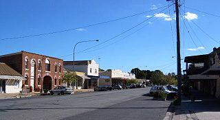
Gunning is a small town on the Old Hume Highway, between Goulburn and Yass in the Southern Tablelands of New South Wales, Australia, about 260 km south-west of Sydney and 75 km north of the national capital, Canberra. Nearby towns and cities are Cullerin, Gundaroo, Dalton, Yass, Murrumbateman and Goulburn.
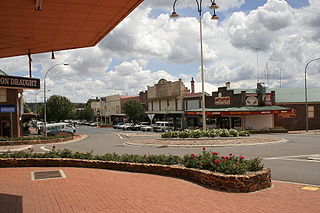
Crookwell is a small town located in the Southern Tablelands of New South Wales, Australia, in the Upper Lachlan Shire. At the 2016 census, Crookwell had a population of 2,641. The town is at a relatively high altitude of 887 metres and there are several snowfalls during the cooler months. The nearest major centre is the city of Goulburn which is about a half-hour drive to the south-east of the town. Crookwell is easily accessible to the state capital of Sydney and also the federal capital of Canberra.

The Division of Hume is an Australian electoral division in the state of New South Wales.

Burrinjuck was an electoral district of the Legislative Assembly in the Australian state of New South Wales from 1950 to 2015.

The Palerang Council was a local government area located in the Southern Tablelands region of New South Wales, Australia. On 12 May 2016 the Minister for Local Government announced dissolution of the Palerang Council with immediate effect. Together with Queanbeyan City the combined council areas were merged to establish the Queanbeyan-Palerang Regional Council. Both councils had opposed the amalgamation. Elections for the new Council area were held in September 2017. The former mayor of Queanbeyan City Council was appointed by the New South Wales Government as administrator until that date.

Goulburn-Oberon Road is a New South Wales country road linking Goulburn near Hume Highway to Oberon. This name is not widely known to most drivers, as the entire allocation is still best known as by the names of its constituent parts: Taralga Road and Abercrombie Road.
Yarrowlumla Shire was a local government area in New South Wales, which surrounded the Australian Capital Territory until February 2004, when it was divided between Palerang Council, Yass Valley Council, Queanbeyan City Council, Tumut Shire and a small part going to the Cooma-Monaro Shire. It had a population of 9,654 and an area of 2,971 square kilometres (1,147 sq mi) in 1999. The council was based in the municipality of Queanbeyan, outside its own territory as was common for rural shires at the time. Most of the area which became the ACT was in Yarrowlumla Shire before it was transferred to the Commonwealth in 1909. This included Yarralumla homestead, which it was named after, although using an alternative spelling.
Bevendale is a rural town located in the Southern Tablelands in New South Wales, Australia. It is 25 km (16 mi) north of Dalton and is located in the Upper Lachlan Shire. The Hume Highway passes through the south of Bevendale.
Tallaganda Shire, was a local government area in New South Wales centered on Braidwood, New South Wales It lasted from colonial times until February 2004, when the local government organisation was absorbed into newly created Palerang Council.

Wollogorang is a locality in the Upper Lachlan Shire and Goulburn Mulwaree Council, New South Wales, Australia. A small part of the locality is in Queanbeyan–Palerang Regional Council. It is located about 35 km southwest of Goulburn and 61 km northeast of Canberra. It lies on both sides of the Federal Highway and on the southern side of the Hume Highway. They intersect nearby to the northeast in the locality of Yarra. At the 2021 census, it had a population of 49.
Culcairn Shire was a local government area in the eastern Riverina region of New South Wales, Australia.
Holbrook Shire was a local government area in the eastern Riverina region of New South Wales, Australia.
Hume Shire was a local government area in the eastern Riverina region of New South Wales, Australia.
Upper Hunter Shire was a local government area in the Hunter region of New South Wales, Australia.
Mulwaree Shire was a local government area in the Southern Tablelands region of New South Wales, Australia.

Crookwell Shire was a local government area in the Southern Tablelands region of New South Wales, Australia.

