Related Research Articles

This is a list of local government areas (LGAs) in New South Wales, sorted by region. As of January 2023 there were 128 local government areas in New South Wales, there are 33 local government areas in Greater Sydney and 95 local government areas and 12 regions in Regional NSW. All councils are listed below in alphabetical order by region. There is also the Unincorporated Far West Region which is not part of any local government area, in the sparsely inhabited Far West, and Lord Howe Island, which is also unincorporated but self-governed by the Lord Howe Island Board.
The City of Botany Bay was a local government area in the eastern region of Sydney, in the state of New South Wales, Australia. The area encompassed the suburbs to the north of Botany Bay, such as Botany. First proclaimed in 1888 as the "Borough of Botany", the council became the "Municipality of Botany" from 1906 to 1996, when it was proclaimed a city as the "City of Botany Bay".

Pittwater Council was a local government area on the Northern Beaches of Sydney, in the state of New South Wales, Australia. It covered a region adjacent to the Tasman Sea about 30 kilometres (19 mi) north of the Sydney central business district. The area is named after Pittwater, the body of water adjacent to much of the area governed. First proclaimed in 1906 as the A Riding of Warringah Shire, the area was proclaimed as the Municipality of Pittwater on 1 May 1992. On 12 May 2016, the Minister for Local Government announced that Pittwater Council would be subsumed into the newly formed Northern Beaches Council. The last mayor of Pittwater Council was Councillor Jacqui Townsend, an independent politician.

The Inner West of Sydney is an area directly west of the Sydney central business district, New South Wales, Australia. The suburbs that make up the Inner West are predominantly located along the southern shore of Port Jackson, stretching south to the shores of the Cooks River. The western boundary of the Inner West is approximately the A3 arterial road, which divides the Inner West from the Greater Western Sydney region. The Inner West is much larger than the Inner West Council local government area. The Inner West roughly corresponds with the Parish of Petersham and Parish of Concord, two cadastral divisions used for land titles.
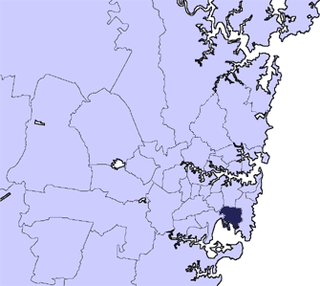
The City of Canada Bay is a local government area in the Inner West of Sydney, New South Wales, Australia. The city was formed on 1 December 2000, following the merger of Concord and Drummoyne councils. The city covers an area of 19.82 square kilometres (7.65 sq mi) and as at the 2016 census had a resident population of 88,015. The city is ultimately named after Canada Bay, a bay on the Parramatta River.

Marrickville Council was a local government area located in the Inner West region of Sydney, Australia. It was originally created on 1 November 1861 as the "Municipality of Marrickville". On 12 May 2016, Marrickville Council was forcibly merged with Ashfield and Leichhardt councils into the newly formed Inner West Council.
Mosman Council is a local government area on the Lower North Shore of Sydney, New South Wales, Australia.

North Sydney Council is a local government area on the Lower North Shore of Sydney, New South Wales, Australia, established on 29 July 1890 through the amalgamation of three boroughs.

North Strathfield is a suburb in the inner-west of Sydney, in the state of New South Wales, Australia. North Strathfield is located 15 kilometres west of the Sydney central business district, in the local government area of the City of Canada Bay. Strathfield and Strathfield South are separate suburbs, to the south.
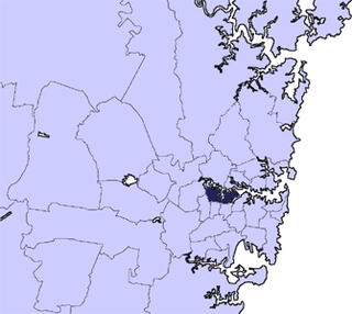
Concord is a suburb in the inner West of Sydney, in the state of New South Wales, Australia. It is 10 kilometres (6.2 mi) west of the Sydney central business district, in the local government area of the City of Canada Bay. Concord West is a separate suburb, to the north-west.

Breakfast Point is a suburb in the West of Sydney, in the state of New South Wales, Australia. Breakfast Point is located 16 kilometres west of the Sydney central business district. It is in the local government area of the City of Canada Bay. People from Breakfast Point are colloquially called Breakfastpointers.

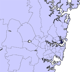
Concord West is a suburb on the periphery of Sydney's inner-west, in the state of New South Wales, Australia. Concord West is located 16 km west of the Sydney central business district, in the local government area of the City of Canada Bay. Concord is a separate suburb, to the east.

Bayview Park ferry wharf is a commuter wharf located in the Sydney suburb of Concord, New South Wales, on Hen and Chicken Bay. It is situated adjacent the namesake Bayview Park reserve, and upon the site of the historical Burwood ferry wharf, where Canadian exiles from the 19th century Lower Canada Rebellion landed in Sydney. Bayview Park was originally serviced by a Matilda Cruises route, before being included on Sydney Ferries' Parramatta River service in 2006, after a brief one-year service by Palm Beach Ferries. Services to the wharf were decommissioned by Sydney Ferries in October 2013, alongside Balmain West after patronage declined to a weekly average of 28 passengers. No operators currently service the wharf, although the structure still remains, with plans to return private ferry services to the wharf as part of a redevelopment project for a factory in eastern Concord.

The local government areas (LGA) of New South Wales are the third tier of government in the Australian state. Under the Local Government Act 1993 (NSW) they can manage their own affairs to the extent permitted by the legislation. They may be designated as cities or otherwise as areas, though the latter units may choose to use titles that had distinctions under older forms of the act. The smallest local government by area in the state is the Municipality of Hunter's Hill 5.7 km2 (2.2 sq mi) and the largest by area is Central Darling Shire Council 53,492 km2 (20,653 sq mi). There are 129 local government areas in the state as of December 2022.
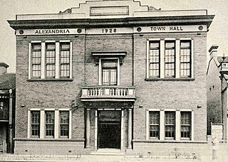
The Municipality of Alexandria was a local government area of Sydney, New South Wales, Australia. Originally part of the municipalities of Redfern from 1859 and Waterloo from 1860, the Borough of Alexandria was proclaimed on 27 August 1868. With an area of 4.2 square kilometres, it included the modern suburbs of Alexandria, Beaconsfield and parts of Eveleigh, St Peters and Erskineville. After a minor boundary change with the Municipality of Erskineville in 1908, the council was amalgamated with the City of Sydney, along with most of its neighbours, with the passing of the Local Government (Areas) Act 1948, although the former council area was later transferred in 1968–1982 and 1989–2004 to the South Sydney councils.

The Municipality of Darlington was a local government area of Sydney, New South Wales, Australia. The municipality was proclaimed in 1864 and, with an area of 0.2 square kilometres, was the smallest municipal council in Sydney. It included the entire suburb of Darlington, excepting a small block between Golden Grove and Forbes streets, which was administered by the Municipality of Redfern in Golden Grove Ward. The council was amalgamated, along with most of its neighbours, with the City of Sydney to the north with the passing of the Local Government (Areas) Act 1948. From 1968 to 1982 and from 1989 to 2004, the area was part of the South Sydney councils.

The Central Coast Council is a local government area in the Central Coast region of New South Wales, Australia. The area is adjacent to the Pacific Highway, Central Coast Highway and the Northern NSW railway line as well as the Pacific Ocean. It has over 40 beaches and over 90km of coastline. The Central Coast Council was formed on 12 May 2016 following the merger of the Gosford City and Wyong Shire councils.

Bayside Council is a southern local government area in New South Wales, Australia. It is located in Sydney, around part of Botany Bay, 7 kilometres (4.3 mi) to 12 kilometres (7.5 mi) south of the CBD. It includes suburbs of Southern Sydney and the St George area separated by the Cooks River as well as a small portion in the Eastern suburbs, south-east of the CBD. It comprises an area of 50 square kilometres (19 sq mi) and as at the 2016 census had a population of 156,058.

The Municipality of The Glebe was a local government area of Sydney, New South Wales, Australia. The municipality was proclaimed on 1 August 1859 and, with an area of 2 square kilometres, included the modern suburbs of Glebe and Forest Lodge. The council was amalgamated with the City of Sydney to the east with the passing of the Local Government (Areas) Act 1948, although parts of the former council area were transferred in 1967 to the Municipality of Leichhardt to the west.

The Municipality of Bexley was a local government area in the St George region of Sydney, New South Wales, Australia. The municipality was proclaimed as the Borough of Bexley on 28 June 1900 when it formally separated from the Municipal District of Hurstville, and included the modern suburbs of Bexley, Bexley North and Kingsgrove, with parts of Carlton, Bardwell Park, Bardwell Valley, Rockdale and Kogarah. From 1 January 1949, the council was amalgamated into the Municipality of Rockdale, with the passing of the Local Government (Areas) Act 1948.
References
- ↑ Spearritt, Peter (2000). Sydney's Century: A History. Sydney: UNSW Press. pp. 272–273. ISBN 9780868405131 . Retrieved 3 November 2017.
- ↑ "181 Municipal District of Concord (1883-1906) Municipality of Concord (1906-1993) Concord Council (1993-2000)". State Records Archives Investigator. State Archives and Records Authority of New South Wales. Retrieved 18 October 2017.
- ↑ "Mayors of Concord". Canada Bay Heritage Society. Retrieved 18 October 2017.
| | This article related to the geography of Sydney is a stub. You can help Wikipedia by expanding it. |