
Yass Valley Council is a local government area in the Southern Tablelands region of New South Wales, Australia. The area is located adjacent to the Hume and Barton Highways and the Main Southern railway line.

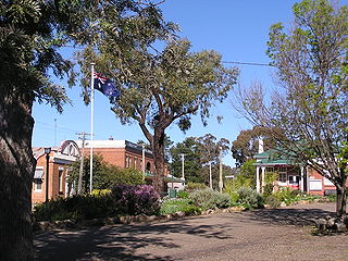
Yass is a town in the Southern Tablelands of New South Wales, Australia in Yass Valley Council. The name appears to have been derived from an Aboriginal word, "Yarrh", said to mean 'running water'.

Upper Lachlan Shire is a local government area in the Southern Tablelands region of New South Wales, Australia. The Shire was formed in February 2004 from Crookwell Shire and parts of Mulwaree, Gunning and Yass Shires.
Binalong (Bine-a-long) is a village in the Southern Tablelands of New South Wales, Australia, 37 km north-west of Yass in Yass Valley Shire. At the 2016 census, Binalong and the surrounding area had a population of 543.

Burrinjuck was an electoral district of the Legislative Assembly in the Australian state of New South Wales from 1950 to 2015.

Baralaba is a rural town and locality in the Shire of Banana in central Queensland, Australia. In the 2016 census, Baralaba had a population of 314 people.

Young Shire was a local government area in the South West Slopes region of New South Wales, Australia. The Shire was located adjacent to the Olympic Highway.

Tumut Shire was a local government area in the South West Slopes region of New South Wales, Australia.
Woolgarlo is a locality on the foreshores of the Yass River arm of Lake Burrinjuck, in the far eastern part of the Riverina in the Yass Valley Shire of New South Wales, Australia. At the 2016 census, it had a population of 26.
Cavan is a rural community situated on the south bank of the Murrumbidgee River in the Yass Valley Shire. At the 2016 census, it had a population of 47. It is situated by road, about 40 kilometres southwest of Yass and 43 northwest of Canberra. It was named after the town of Cavan in Ireland. It is reportedly owned by Rupert Murdoch.

Goodradigbee River, a perennial stream that is part of the Murrumbidgee catchment within the Murray-Darling basin, is located in the Snowy Mountains district of New South Wales, Australia.
Yass Municipality was a Local Government Area of New South Wales from 1873 until 1980, when it was merged with Goodradigbee Shire to create Yass Shire.

Brindabella is a locality in south-east New South Wales, Australia, mainly in the area of Snowy Valleys Council and partly in Yass Valley Council. It is reached by the Brindabella Road from the Australian Capital Territory over the Brindabella Ranges. It is significant as the early home of Miles Franklin, who wrote a well known book called Childhood at Brindabella. It had a population of 22 at the 2016 census, who live in the Brindabella Valley. The locality also includes a large unpopulated area consisting of parts of the Brindabella National Park, the Kosciuszko National Park and the Bimberi Nature Reserve and of state forests.

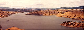
The Taemas Bridge is a two-lane road bridge that carries the Wee Jasper Road across the Murrumbidgee River, at the settlement of Taemas, near Wee Jasper in the Yass Valley Council local government area of New South Wales, Australia. The bridge crosses on the river just before it enters Lake Burrinjuck, which has been created by the Burrinjuck Dam. The bridge is a key part of the road between Yass and Wee Jasper, and from there, to Tumut. The bridge is located approximately 26 kilometres (16 mi) from Yass and 22 kilometres (14 mi) from Wee Jasper. The property is owned by Transport for NSW. Under the Heritage Act, 1977 (NSW) s 170, the bridge was added to the New South Wales State agency heritage register on 18 August 2005.

Cootamundra–Gundagai Regional Council (CGRC) is a local government area located in the South West Slopes and Riverina regions of New South Wales, Australia. The council was formed on 12 May 2016 through a merger of the Cootamundra and Gundagai shires. Originally named Gundagai Council, the name was changed to Cootamundra–Gundagai Regional Council on 7 September 2016.

Jerrawa is a locality in the Upper Lachlan Shire, New South Wales, Australia. It lies on the north side of the Hume Highway about 30 km to the east of Yass and was served by Jerrawa railway station on the Main Southern line between Sydney and Melbourne between 1876 and 1975. At the 2016 census, it had a population of 73.

Yass Town railway station is a heritage-listed former railway station and now museum at Yass Town Tramway, Yass, Yass Valley Shire, New South Wales, Australia. It is also known as the Yass Railway Museum. The property was added to the New South Wales State Heritage Register on 2 April 1999.
Mulwaree Shire was a local government area in the Southern Tablelands region of New South Wales, Australia.

Crookwell Shire was a local government area in the Southern Tablelands region of New South Wales, Australia.
