Related Research Articles

The City of Shoalhaven is a local government area in the south-eastern coastal region of New South Wales, Australia. The area is about 200 kilometres (120 mi) south of Sydney. The Princes Highway passes through the area, and the South Coast railway line traverses the northern section, terminating at Bomaderry. At the 2021 census, the population was 108,531.

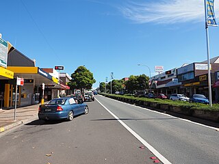
Milton is a village in the South Coast region of New South Wales, Australia, within the City of Shoalhaven. It was founded in 1860, named after the property of post master George Knight and became an important regional centre during the 19th Century. Today, Milton remains one of the two main commercial centres of the Milton-Ulladulla district, with a population at the 2016 census of 1,663. It is a popular stopping place for travellers on the Princes Highway which runs through the centre of town. In recent years, Milton has undergone a resurgence largely influenced by the local tourism industry and an influx of residents to the district seeking a seachange. Several new housing estates are being developed on the fringes of the village and new boutique stores, cafes and bed and breakfast type businesses have located in the town.
Ulladulla is a coastal town in New South Wales, Australia in the City of Shoalhaven local government area. It is on the Princes Highway about 230 kilometres (140 mi) south of Sydney, halfway between Batemans Bay to the south and Nowra to the north. Ulladulla has close links with the nearby historic settlement of Milton and many services are shared between these towns.
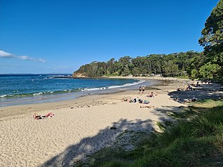
Mollymook is a town located on the South Coast of New South Wales, Australia approximately three hours' drive south of Sydney within the City of Shoalhaven local government area. At the 2016 census, Mollymook had a population of 1,083 while the adjacent locality of Mollymook Beach was home to a further 2,447 people. Geographically, Mollymook is considered part of the Milton-Ulladulla district, a coastal corridor of urban development stretching from Burrill Lake, south of Ulladulla to Mollymook's northern neighbour, Narrawallee and the historic town of Milton a few kilometres inland.

South Coast is an electoral district of the Legislative Assembly in the Australian state of New South Wales. It incorporates almost all of the City of Shoalhaven to the south of the Shoalhaven River, notably Nowra, Ulladulla and Milton.

The Illawarra Steam Navigation Company was a shipping company that serviced the south coast of New South Wales, Australia from 1858 to the early 1950s. It was formed through the amalgamation of the General Steam Navigation Company, the Kiama Steam Navigation Company and the Shoalhaven Steam Navigation Company, each of whom serviced parts of the south coast with their respective vessels. After merging, the new company held a near monopoly in regard to shipping on the south coast, and their fleet visited every significant port between Sydney and the border of Victoria. The company transported both passengers and a range of produce, including livestock, and hence it became known as the 'Pig and Whistle Line': it was said that ships would wait an hour for a pig but not a minute for a passenger.

Kioloa is a small hamlet located on the South Coast of New South Wales, Australia and is within the City of Shoalhaven local government area. It is pronounced by locals as 'Ky-ola'. At the 2016 census, Kioloa had a population of 257.
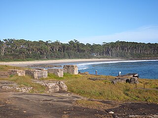
Bawley Point is a small coastal hamlet in New South Wales, Australia, in the Shoalhaven with a population of 698 people at the 2016 census. It is located 30 minutes south of Ulladulla, New South Wales, and 30 minutes north of Batemans Bay on the South Coast of NSW. The town's name is believed to be derived from an Aboriginal word meaning "Brown snake".

Tabourie Lake, formerly Toubouree Lake is a small village in the suburb of Lake Tabourie, in the South Coast region of New South Wales, Australia and is within the City of Shoalhaven local government area. The village takes its name from the lagoon formed at the entry of Tabourie Creek into the ocean. Crampton Island lies immediately off shore with access available by foot at low tide. Lake Tabourie is located within Meroo National Park and the bush surrounding the lake is made up of ecologically unique Bangalay Sand Forest. A caravan and camping park is located between the beach and lake. The village boasts a small museum, opened in 1965 with a collection of local historical exhibits, including fauna, Aboriginal artifacts, and historical furnishings and machinery. The museum and collection was given to the Shoalhaven City Council by its founder Jack Nicholson in 1983.

Burrill Lake is a small village on the Princes Highway in the South Coast region of New South Wales, Australia. It is a seaside suburb of the Milton-Ulladulla district, a part of the City of Shoalhaven local government area and surrounds the lake of the same name. In 2021, Burrill Lake had a population of 1,782. The name of the town is derived from an Aboriginal word meaning 'wallaby'.

Termeil is a small village in the Shoalhaven area of New South Wales, Australia. Termeil is a predominantly rural hamlet at the junction of Bawley Point Road, providing access to the beachside communities of Bawley Point and Kioloa and the Princes Highway. At the 2011 census the population was 252. Ulladulla Bus Lines route 741 serves Termeil twice per day on weekdays.

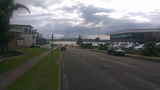
Kings Point is a village in the South Coast region of New South Wales, Australia. The village forms part of the Milton Ulladulla urban area in the southern Shoalhaven. Kings Point is predominantly a residential suburb on the shores of Burrill Lake. A small light industrial area to the east separates the village from Ulladulla. At the 2016 census, Kings Point had a population of 553. The lakeside location makes Kings Point popular for fishing and water sports - the Ulladulla Water Ski Club and public boat ramp facilities allow locals and visitors to take full advantage.
Bendalong (Bendy) is a small town situated on the South Coast of New South Wales. It is located in the region of Ulladulla, in the City of Shoalhaven. At the 2016 census, it had a population of 95.
Milton Ulladulla Hospital is a local public hospital located in the town of Milton, New South Wales. The hospital services the Milton Ulladulla district in the Shoalhaven. It is located on the Princes Highway at Milton and is approximately 7 km (4.3 mi) by road from Ulladulla. MUH is operated by the Illawarra Shoalhaven Local Health District. In summer months, tourism brings a large influx of population to the region, requiring operational flexibility.
Clyde Shire was a local government area in the South Coast region of New South Wales, Australia.
Cambewarra Shire was a local government area in the South Coast region of New South Wales, Australia.
A by-election was held for the New South Wales Legislative Assembly electorate of Shoalhaven on 21 August 1871 because Thomas Garrett resigned to accept appointment as a police magistrate at Berrima.
The Municipality of Nowra was a municipality of New South Wales that existed from 1871 to 1948.
Croobyar is a rural suburb of the Milton-Ulladulla district within the City of Shoalhaven on the New South Wales South Coast in Australia. It is located immediately west of Milton and in 2021 the population was 174. The main industry in Croobyar is dairy farming.

Yatte Yattah is a historically significant suburb on the South Coast of New South Wales. It is located on the Princes Highway about 4km north of Milton and 2km south of Conjola Lake. At the 2021 Census, the population was 189. Settled in 1827, Yatte Yattah was a pioneer town in the decades preceding the establishment of nearby Milton and Ulladulla. Selected at the time for its highly fertile soils and lucrative red cedar, the first settlers in Yatte Yattah used convicts to procure timber, build roads and dig extensive drains along Narrawallee Creek. In 1827 a local aboriginal man helped Thomas Kendall cut a track from his land grant in Yatte Yattah to a natural bay in the south. Kendall turned the bay into a boat harbour so he could ship cedar and produce from Yatte Yattah to Sydney and Illawarra. Eventually this makeshift port would become known as Ulladulla Harbour. During this boom period Yatte Yattah had a functioning school, church and post office. Today, Yatte Yattah is characterised by picturesque farming estates and private rural retreats. There are views of Pigeon House Mountain and the Budawang Ranges. There are many surfing beaches near Yatte Yattah and with incereasing popularity the highway is known to become congested during peak holiday season.
References
- ↑ "Municipality of Ulladulla". State Records Authority of New South Wales. Government of New South Wales.
| | This Shoalhaven geography article is a stub. You can help Wikipedia by expanding it. |