The Shire of Beaudesert was a local government area located in South East Queensland, Australia, stretching from the New South Wales border, along the Gold Coast hinterland to the urban fringes of the cities of Brisbane and Ipswich. The Shire covered an area of 2,854.3 square kilometres (1,102.1 sq mi), and existed from 1879 until its abolition on 15 March 2008, following which it was split between Logan City and the new Scenic Rim Region.

The Shire of Erina was a local government area covering the majority of the Central Coast region of New South Wales, Australia. The shire was proclaimed on 7 March 1906 as a result of the passing of the Local Government (Shires) Act 1905 and covered most of the Central Coast region with the exception of the Town of Gosford, which had been incorporated in 1886.
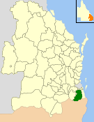
The Coonabarabran Shire was a local government area in the Orana region of New South Wales, Australia. The Shire was proclaimed on 7 March 1906 with the enactment of the Local Government (Shires) Act 1905 and was centred on the town of Coonabarabran, but also covered a wide area extending to smaller towns, such as Baradine and Binnaway. On 25 August 2004, the Shire voluntarily amalgamated with the adjoining Coolah Shire to form the Warrumbungle Shire.

The Shire of Nerang was a local government area in South East Queensland, Australia. The shire existed as a local government entity from 1879 until 1949.

The Shire of Tinana is a former local government area in the Wide Bay–Burnett area of Queensland, Australia. It is centred on Tinana, on the southern bank of the Mary River, with the Borough of Maryborough on the northern bank. It existed from 1880 to 1917.

The Shire of Highfields is a former local government area on the Darling Downs in Queensland, Australia. It existed between 1879 and 1949.

Local Government (Shires) Act 1905 was a landmark New South Wales statute notable for the compulsory incorporation of local government areas for around 40% of the area of New South Wales. The Act created 134 rural shires, many surrounding a small urban area separately and voluntarily incorporated under the Municipalities Act 1858 and the following Municipalities Act 1867 and Municipalities Act 1897 As well as the compulsory incorporation of rural areas, the Local Government (Shires) Act repealed the Municipalities Act - bringing local government under one legislative framework.
Hume Shire was a local government area in the eastern Riverina region of New South Wales, Australia.
Gundurimba Shire was a local government area in the Northern Rivers region of New South Wales, Australia.
Terania Shire was a local government area in the Northern Rivers region of New South Wales, Australia.
Upper Hunter Shire was a local government area in the Hunter region of New South Wales, Australia.
Copmanhurst Shire was a local government area in the Northern Rivers region of New South Wales, Australia.
Tomki Shire was a local government area in the Northern Rivers region of New South Wales, Australia.
Woodburn Shire was a local government area in the Northern Rivers region of New South Wales, Australia.
Orara Shire was a local government area in the Northern Rivers region of New South Wales, Australia.
Dorrigo Shire was a local government area in the Mid North Coast region of New South Wales, Australia.
Mulwaree Shire was a local government area in the Southern Tablelands region of New South Wales, Australia.
Cobbora Shire was a local government area in the Orana region of New South Wales, Australia.
Nepean Shire was a local government area in Sydney in New South Wales, Australia.
Kearsley Shire was a local government area in the Hunter region of New South Wales, Australia.