Related Research Articles
Jerilderie is a small, rural town in the southern Riverina region of New South Wales, Australia. It is part of the Murrumbidgee Local Government Area. At the 2021 census, Jerilderie had a population of 922 people.

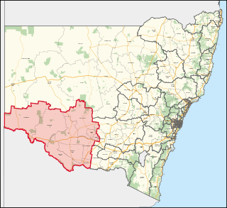
Balranald is a town within the local government area of Balranald Shire, in the Riverina district of New South Wales, Australia.

The City of Gosford was a local government area that was located in the Central Coast region in the state of New South Wales, Australia. The incorporation of Gosford dates back to 1886 when the Town of Gosford was proclaimed as the Borough of Gosford, becoming the Municipality of Gosford from 1906. In 1908, the Gosford Municipality merged into Erina Shire which covered the remaining Central Coast area outside of Gosford, but regained its independence in 1936. From 1 January 1947, local government in the Central Coast region was reorganised, creating Gosford Shire and Wyong Shire, and the final boundaries of Gosford City Council date from this period. From 1 January 1980, Gosford Shire was granted city status, becoming the City of Gosford. On 12 May 2016 the Minister for Local Government amalgamated the City of Gosford and Wyong Shire Councils. The Central Coast Council was established on the same day, covering the combined areas.

The Riverina is an agricultural region of south-western New South Wales, Australia. The Riverina is distinguished from other Australian regions by the combination of flat plains, warm to hot climate and an ample supply of water for irrigation. This combination has allowed the Riverina to develop into one of the most productive and agriculturally diverse areas of Australia.

Jerilderie Shire was a local government area in the Riverina region of southern New South Wales, Australia. The Shire was located adjacent to the Newell Highway. The Shire was declared in 1918 after the amalgamation of the former Municipality of Jerilderie and Wunnamurra Shire. It was dissolved in 2016 after its amalgamation with Murrumbidgee Shire to create Murrumbidgee Council

Leeton is a town located in the Riverina region of New South Wales, Australia. Leeton is situated in the Murrumbidgee Irrigation Area. It is the administrative centre of the Leeton Shire Council local government area, which includes neighbouring suburbs, towns and localities such as Yanco, Wamoon, Whitton, Gogeldrie, Stanbridge and Murrami. Situated in one of the most productive farming regions in the state, the town was designed by Walter Burley Griffin and purpose-built for the irrigation schemes announced by the New South Wales government in the early 20th century. The Leeton Shire possesses numerous citrus, rice, cotton, grape, walnut and wheat farms. Leeton is known as Australia's Rice Capital, as well as The Heart of SunRice Country, as it is home to the headquarters of SunRice corporation, one of Australia's largest food exporters. Other industry includes Arnott’s Biscuits, the Daily Drinks Company, JBS Australia, Webster Limited, and Murrumbidgee Irrigation Limited. Tony Reneker is the current mayor of Leeton.

Murrumbidgee Shire was a local government area in the Riverina region of south western New South Wales, Australia. The Shire was located adjacent to the Murrumbidgee River and the Newell Highway.

Leeton Shire is a local government area in the Riverina region of New South Wales, Australia. The Shire is located adjacent to the Murrumbidgee River and falls within the Murrumbidgee Irrigation Area.

The Murrumbidgee Irrigation Area (MIA) is geographically located within the Riverina area of New South Wales. It was created to control and divert the flow of local river and creek systems for the purpose of food production. The main river systems feeding and fed by the area are the Murrumbidgee and the Tumut. It is one of the most diverse and productive regions in Australia contributing over A$5 billion annually to the Australian economy.

Wakool Shire was a local government area in the Riverina region of New South Wales, Australia. The Shire was located between the Murray River and the Murrumbidgee River and adjacent to the Sturt Highway. Towns in the Shire are Barham, Moulamein, Tooleybuc, Wakool and Koraleigh.

Berrigan Shire is a local government area in the southern Riverina region of New South Wales, Australia. The Shire lies on the New South Wales State border with Victoria formed by the Murray River. The Shire is adjacent to the Newell and Riverina Highways. The Shire is a mainly agricultural region, with dairying, cattle raising, woolgrowing and cropping the main activities. The vast majority of the Shire is irrigated. Tourism is another major activity, concentrated on the river towns of Tocumwal and Barooga.

Cootamundra is an electoral district of the Legislative Assembly in the Australian state of New South Wales.

The Shire of Erina was a local government area covering the majority of the Central Coast region of New South Wales, Australia. The shire was proclaimed on 7 March 1906 as a result of the passing of the Local Government (Shires) Act 1905 and covered most of the Central Coast region with the exception of the Town of Gosford, which had been incorporated in 1886.
Murray is an electoral district in the Australian state of New South Wales.
Ambrose George Enticknap was an Australian politician and a member of the New South Wales Legislative Assembly from 1941 until 1965. He was a member of the Labor Party and held numerous ministerial positions between 1950 and 1965.

The Taemas Bridge is a two-lane road bridge that carries the Wee Jasper Road across the Murrumbidgee River, at the settlement of Taemas, near Wee Jasper in the Yass Valley Council local government area of New South Wales, Australia. The bridge crosses on the river just before it enters Lake Burrinjuck, which has been created by the Burrinjuck Dam. The bridge is a key part of the road between Yass and Wee Jasper, and from there, to Tumut. The bridge is located approximately 26 kilometres (16 mi) from Yass and 22 kilometres (14 mi) from Wee Jasper. The property is owned by Transport for NSW. Under the Heritage Act, 1977 (NSW) s 170, the bridge was added to the New South Wales State agency heritage register on 18 August 2005.

The Jerilderie Herald and Urana Advertiser, later published as the Jerilderie-Coleambally Herald and Urana Advertiser, was a weekly newspaper published in Jerilderie, New South Wales, Australia.

Murrumbidgee Council is a local government area in the Riverina region of New South Wales, Australia. This area was formed in 2016 from the merger of the Murrumbidgee Shire with the neighbouring Jerilderie Shire.
Austin William Evans is an Australian politician. He was a Nationals member of the New South Wales Legislative Assembly from 14 October 2017 to 23 March 2019, representing Murray after a by-election held to replace Adrian Piccoli.

Murrumbidgee River railway bridge is a heritage-listed disused railway bridge on the Tocumwal railway line crossing from Narrandera to Gillenbah, both in Narrandera Shire, New South Wales, Australia. It was designed by John Whitton in his capacity as Engineer-in-Chief for Railways, and built in 1884–85 by Halliday & Owen with ironwork supplied by English firm Westwood, Baillie. It is also known as Narrandera Lattice Railway Bridge. The property was added to the New South Wales State Heritage Register on 2 April 1999 and was added to the Register of the National Estate on 15 May 1990.
References
- ↑ "WUNNAMURRA (Jerilderie)". The Farmer and Settler . Vol. III, no. 26. New South Wales, Australia. 31 July 1908. p. 7. Retrieved 17 July 2017– via National Library of Australia.
- ↑ "History of Jerilderie Shire Council". Murrumbidgee Council. Murrumbidgee Council. Retrieved 22 May 2016.