
Harden–Murrumburrah is a township and community in the Hilltops Region and is located in the South West Slopes of New South Wales in Australia. Harden is adjacent to both the Canberra region of the Australian Capital Territory and the Riverina Region in the southwest area of NSW. The town is a twin town between Harden and Murrumburrah.

The Hills Shire is a local government area in the Greater Sydney region of Sydney, New South Wales, Australia. The suburb is north-west of the Sydney central business district, and encompasses 401 square kilometres (155 sq mi) stretching from the M2 Hills Motorway in the south to Wiseman's Ferry on the Hawkesbury River in the north. The Hills Shire had a population of 157,243 as at the 2016 census.

Burrinjuck was an electoral district of the Legislative Assembly in the Australian state of New South Wales from 1950 to 2015.

The Snowy River Shire was a local government area in the Australian Alps region of New South Wales, Australia from 1939 until May 2016. It was named after the Snowy River that runs through it. Prior to 1936, it had been named as Dalgety Shire since establishment in 1906.

Gundagai Shire was a local government area in the Riverina region of New South Wales, Australia. On 12 May 2016, Gundagai Shire was abolished and merged with the neighbouring Cootamundra Shire to establish Cootamundra-Gundagai Regional Council.

Boorowa Council was a local government area in the South West Slopes region of New South Wales, Australia. The LGA was located adjacent to the Lachlan Valley Way and included Boorowa and the small towns of Rye Park, Rugby, Frogmore and Reids Flat. Burrowa LGA was formed on 1 September 1944 through the amalgamation of Murrungal Shire and the Municipality of Burrowa.

Young Shire was a local government area in the South West Slopes region of New South Wales, Australia. The Shire was located adjacent to the Olympic Highway.

Harden Shire was a local government area in the South West Slopes region of New South Wales, Australia. The Shire included the twin towns of Harden and Murrumburrah and the small towns of Galong, Jugiong, Wombat and Kingsvale.

Cootamundra Shire was a local government area in the Riverina region of New South Wales, Australia. The Shire was located adjacent to the Olympic Highway, the Burley Griffin Way and the Main South railway line. The Shire included the town of Cootamundra and the small towns of Stockinbingal, Brawlin and Wallendbeen and the locality of Frampton. The Shire was created on 1 April 1975 by the amalgamation of Jindalee Shire and the Municipality of Cootamundra.

Tumut Shire was a local government area in the South West Slopes region of New South Wales, Australia.

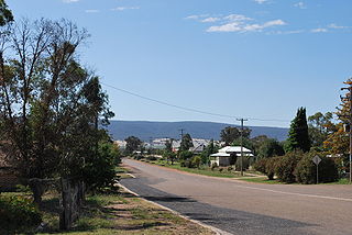
Murrumburrah is a township in New South Wales, Australia, part of a twin town with Harden. The town is in Hilltops Council local government area in the South West Slopes area of NSW. It is on the Burley Griffin Way, the major link from the Riverina to the Hume Highway near Yass, and ultimately Sydney, Canberra and the coast.

The Blayney–Demondrille railway line is a railway line in New South Wales, Australia. The line is used mainly for grain haulage and is owned by the Transport Asset Holding Entity, a government department of Transport for NSW. However, in 2004 the Australian Rail Track Corporation became responsible for operations over the line. The Lachlan Valley Railway operated heritage and tourist trains over the line, based at Cowra. It previously also operated general goods trains.

The Demondrille railway station is a heritage-listed disused railway station on the Main South railway line in Murrumburrah, Hilltops Council, New South Wales, Australia. The station is located at the junction of the branch line to Cowra and Blayney with the Main South line. It consisted of a pair of island platforms, one on the mainline and one on the branchline, with a pair of signal boxes controlling the junction, which was formerly a triangle junction. The station opened in 1885 and closed in 1974. The platforms have been removed but the mainlines have not been straightened.

Harden railway station is a heritage-listed railway station located on the Main South line in New South Wales, Australia. It serves the town of Harden. It was added to the New South Wales State Heritage Register on 2 April 1999.
Bendick Murrell is a town in the South West Slopes region of New South Wales, Australia.
George Brenner was an Australian politician. He was a Labor member of the New South Wales Legislative Council from 1981 to 1991.

Hilltops Council is a local government area in the South West Slopes region of New South Wales, Australia. This area was formed on 12 May 2016 from the merger of Boorowa Council, Harden Shire and Young Shire. The local government area covers much the same area as the Hilltops wine region.

Cootamundra–Gundagai Regional Council (CGRC) is a local government area located in the South West Slopes and Riverina regions of New South Wales, Australia. The council was formed on 12 May 2016 through a merger of the Cootamundra and Gundagai shires. Originally named Gundagai Council, the name was changed to Cootamundra–Gundagai Regional Council on 7 September 2016.
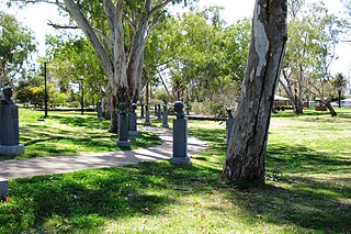
The Cricket Captains' Walk is a collection of specially commissioned bronze busts of Test captains of the Australian men’s national cricket team, arrayed on pedestals on either side of a looping path set in a large public park in Cootamundra, New South Wales. The all-weather path, which starts and ends at Wallendoon Street is family, jogger, and wheelchair friendly, and approximately 250 metres long.
Cunningar is a locality in the Hilltops Council local government area, within the South West Slopes region of New South Wales, Australia. It is located immediately to the east of the town of Harden. There is a parish of the County of Harden of the same name, which comprises a part of the area of the locality.
