History
Before European settlement the Harden area was inhabited by the Wiradjuri people. Hume and Hovell passed nearby in 1824. In the late 1820s, the 'Murrumburra' was established. Its superintendent, James Kennedy, established an inn on the townsite in the late 1840s. Gold was found in the area in the 1850s. [3] In 1858, it was gazetted as the name Murrimboola, which was a Wiradjuri word meaning two water holes. In mid-1872, a traveller made the following comments about Murrumburrah, "a small township on the road to Lambing Flat":
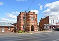
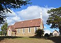
Murrumburrah has two churches, a school, three hotels, the same number of stores, and a good steam flour mill. The Roman Catholic Church is a fine stone building on a hill above the town, and looks very picturesque; the Wesleyan Chapel is a small wooden building. The principal hotels are Mr. Murphy’s and Mr. Dillon’s. The former owns the flour mill, a good brick building, three stories high. It may be mentioned that a good deal of wheat is grown in the district. [4]
A railway station was opened one km east of Murrumburrah on the Main Southern line in 1877 as Murrumburrah station, but changed its name to Harden station , the year after the opening of a new station in Murrumburrah in 1879. [5] Harden has remained as the main station and, as a result, became the main town.
Young is a town in the South West Slopes region of New South Wales, Australia and the largest town in the Hilltops Region. The "Lambing Flat" Post Office opened on 1 March 1861 and was renamed "Young" in 1863.

Boorowa is a farming village in the Hilltops Region in the south west slopes of New South Wales, Australia. It is located in a valley 340 kilometres (210 mi) southwest of Sydney around 490 metres (1,610 ft) above sea-level. The town is in Hilltops Council local government area.

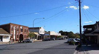
Harden–Murrumburrah is a township and community in the Hilltops Region and is located in the South West Slopes of New South Wales in Australia and is adjacent to both the Canberra region of the Australian Capital Territory and the Riverina Region in the southwest area of NSW. The town is a twin town between Harden and Murrumburrah.

Cootamundra, nicknamed Coota, is a town in the South West Slopes region of New South Wales, Australia and within the Riverina. It is within the Cootamundra-Gundagai Regional Council. At the 2016 Census, Cootamundra had a population of 6,782. It is located on the Olympic Highway at the point where it crosses the Muttama Creek, between Junee and Cowra. Its railway station is on the Main Southern line, part of the Melbourne-to-Sydney line.
Gunning is a small town on the Old Hume Highway, between Goulburn and Yass in the Southern Tablelands of New South Wales, Australia, about 260 km south-west of Sydney and 75 km north of the national capital, Canberra.

Breadalbane is a small village located in the Southern Tablelands of New South Wales, Australia in Upper Lachlan Shire. It is located on the Lachlan River headwaters and not far from Goulburn. At the 2016 census, Breadalbane had a population of 100.

Gerogery is a town established on Wiradjuri land in the Riverina region of the Australian state of New South Wales. The town is in the Greater Hume Shire local government area and on the Main South railway line between Sydney and Melbourne, where it intersects with the Olympic Highway. Gerogery serves a rural farming community. Gerogery has a temperate climate. It lies close to the Great Yambla Range, with its striking Tabletop and Sugar Loaf ridge at the southern end.

Wallendbeen is a small town in southern New South Wales, Australia, administered by Cootamundra-Gundagai Regional Council. At the 2011 census, Wallendbeen and the surrounding area had a population of 305. The town's name is derived from an aboriginal word for "stony hill".

Ariah Park is a small town in the Riverina region of New South Wales, Australia, 35 kilometres (22 mi) west of Temora and 65 kilometres (40 mi) south of West Wyalong. The town is within the Temora Shire near Burley Griffin Way. On Census night 2011, Ariah Park had a population of 268 people. The town is listed by the National Trust as a Conservation Area.

Bowning is a small town in the Southern Tablelands, 14 kilometres (8.7 mi) west of Yass on the Hume Highway in Yass Valley Shire. Bowning is an aboriginal word meaning 'big hill'. At the 2016 census, Bowning and the surrounding area had a population of 573.

Woodstock is a village in the central west of New South Wales, Australia, 21 kilometres (13 mi) north east of Cowra. It contains remains of a brief goldrush during the late 19th century which left behind a number of substantial buildings before the village relapsed into relative isolation. It includes a restored railway station, hotel and a memorial hall. At the 2011 census, Woodstock had a population of 812.
Peak Hill is a town in Parkes Shire in the Central West of New South Wales, Australia. At the 2016 census, Peak Hill had a population of 1,106 people. It is located on the Newell Highway and the Parkes to Narromine railway line.
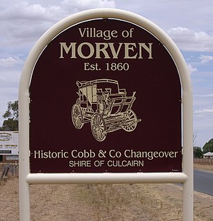
Morven is a small village about 7 kilometres east of Culcairn in the eastern Riverina district of New South Wales, Australia. At the 2006 census, Morven has a population of 464 people.

Jugiong is a locality and town on the banks of the Murrumbidgee River near its confluence with Jugiong Creek. in the Hilltops Council Local Government area, New South Wales, Australia. It is situated just off the Hume Highway, by road, about 30 kilometres southwest from Bookham and 40 kilometres northeast from Gundagai.

Wombat is a town in South West Slopes region of New South Wales, Australia. It is situated on the Olympic Highway, 15 kilometres (9.3 mi) south-west of the regional centre of Young. It is in the local government area of Hilltops Council.

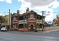
Harden railway station is a heritage-listed railway station located on the Main South line in New South Wales, Australia. It serves the town of Harden. It was added to the New South Wales State Heritage Register on 2 April 1999.
Bendick Murrell is a town in the South West Slopes region of New South Wales, Australia.

Demondrille Shire was a local government area in the South West Slopes region of New South Wales, Australia.
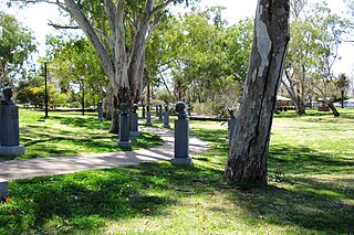
The Cricket Captains' Walk is a collection of specially commissioned bronze busts of Test captains of the Australian men’s national cricket team, arrayed on pedestals on either side of a looping path set in a large public park in Cootamundra, New South Wales. The all-weather path, which starts and ends at Wallendoon Street is family, jogger, and wheelchair friendly, and approximately 250 metres long.
Cunningar is a locality in the Hilltops Council local government area, within the South West Slopes region of New South Wales, Australia. It is located immediately to the east of the town of Harden. There is a parish of the County of Harden of the same name, which comprises a part of the area of the locality.