Shire of Erina New South Wales | |||||||||||||||
---|---|---|---|---|---|---|---|---|---|---|---|---|---|---|---|
![]() Erina Shire Chambers on Mann Street, Gosford, built 1912. | |||||||||||||||
Population | 9,534 (1933 census) [1] | ||||||||||||||
Established | 7 March 1906 | ||||||||||||||
Abolished | 1 January 1947 | ||||||||||||||
Council seat | Erina Shire Chambers | ||||||||||||||
Region | Central Coast | ||||||||||||||
County | Northumberland | ||||||||||||||
|
The Shire of Erina was a local government area covering the majority of the Central Coast region of New South Wales, Australia. The shire was proclaimed on 7 March 1906 as a result of the passing of the Local Government (Shires) Act 1905 and covered most of the Central Coast region with the exception of the Town of Gosford, which had been incorporated in 1886.
The shire expanded on 23 January 1908, when the Municipality of Gosford merged into Erina Shire, but contracted on 1 August 1928 when D Riding separated to form Woy Woy Shire, and following a period of dysfunction in the mid-1930s, Gosford separated again from 24 October 1936. Erina Shire was abolished on 1 January 1947 with the reorganisation of local government in the Central Coast region following the end of the Second World War, with the council area split between Gosford Shire and Wyong Shire.
The traditional Aboriginal inhabitants of the lands now known as the Brisbane Water were the Guringai people of the Eora nation. [2] The Darkingung people occupied large areas inland west towards Rylstone, and north to Cessnock and Wollombi. [3]
In 1811, the Governor of New South Wales, Lachlan Macquarie, gave the first land grant in the region to William Nash, a former marine of the First Fleet. No further grants were made in the area until 1821. [4] In 1839, Governor Sir George Gipps named the town of Gosford after his friend, The Earl of Gosford. [3]
In 1840, the Brisbane Water Police District was proclaimed covering the area from the Hawkesbury River to Lake Macquarie and which administered local government under the control of magistrates. [5] [6] In 1843, the Brisbane Water District Council was proclaimed on the same boundaries as the Police District, and replaced the appointed magistrates with an elected council as part of an early attempt to establish local government administration throughout the colony. [7] This experiment in local government was not very successful, with much public opposition focused on the issue of increased taxation, and a lack of oversight and faulty administration led to the collapse of many of these District Councils. The Brisbane Water District Council had ceased to exist by 1855, and the NSW Parliament passed the Municipalities Act in 1858, which allowed for the creation of Municipalities and Boroughs if a petition of as few as 50 signatures was presented to the government. [8] However, no petition was ever sent from the residents of Brisbane Water to the government under this act, and local matters reverted to the police magistrates for determination. [9]
Under the succeeding Municipalities Act, 1867, a petition was subsequently accepted in incorporate the Town of Gosford as the "Borough of Gosford" on 11 November 1886. [10] The remaining area of the Brisbane Water Police District outside of Gosford continued to be administered by the police magistrates until 1906. [11]
On 7 March 1906, this area became the Erina Shire, when it was proclaimed by the NSW Government Gazette along with 132 other new Shires as a result of the passing of the Local Government (Shires) Act 1905 . [12] On 16 May 1906, the Shire was divided in to three Ridings (A, B, C) and five temporary Councillors were appointed (John Bourke of Kincumber, John Martin Moroney of Woy Woy, Harold Stanley Robinson of Penang, Manasseh Ward of Gosford, and Alexander Wilkinson of Wyong). [13] [14] The Temporary Council first met at Gosford Courthouse on 13 June 1906 and Manasseh Ward was elected as the chairman. [15] The first election was held on 24 November 1906 and the first meeting of the elected nine-member Council was held at the Gosford Courthouse on 5 December 1906, with Councillor Ward elected to continue serving as the first Shire President. [16] [17]
With the coming into effect of the Local Government Act, 1906, the Borough of Gosford became the Municipality of Gosford, as well as the power of Councils to petition the government to dissolve and merge with other Councils. In July 1907 a petition from the Municipality of Gosford was published in the Government Gazette requesting to merge with Erina Shire, the first Council to do so under the 1906 act. [18] However, owing to objections from the Wyong Progress Association and the Erina Shire Council, a public inquiry was established by the Secretary for Public Works, where it was heard that the Gosford Municipality was in debt and desired to merge with Erina to resolve its financial issues. [19] Despite objections, the commissioner returned a recommendation for the merger and a proposal for a six-ward model was considered and accepted at a conference held on 30 September 1907. [20] [21] The proposal for a six-ward Erina Shire with Gosford becoming F Riding was subsequently proclaimed and came into effect on 23 January 1908. [22] [23] [24] The new Shire Council Chambers on Mann Street, Gosford, were officially opened on 4 May 1912. [25]
With the substantial size of Erina Shire covering the entirety of the Central Coast region, some local groups began to organise to separate from the shire and manage their own areas. This occurred in D Riding in particular, where in 1921, a group of ratepayers angered by what they saw as a general neglect of their local area, formed an organisation to work towards the separation of the Woy Woy Peninsula area from Erina Shire. [26] [27] On 27 April 1928 a proposal for separation was received and the Shire of Woy Woy was subsequently proclaimed on 1 August 1928. [28] [29]
In March 1936, three Councillors of Erina Shire were dismissed from office for having held office while subject to a special disqualification, and it was also revealed that Council staff had not been paid since February. [30] [31] As the council could not meet due to lack of quorum, on 24 March 1936 the Minister for Local Government, Eric Spooner, dismissed the council and appointed an Administrator, B. C. Hughes. [32] [33] Spooner commissioned Hughes to undertake an inquiry into the administration of Erina Shire and, following a January petition from Gosford and Point Clare residents for a new Gosford municipality, also to investigate the question of the separation of Gosford from the Shire. [34] [35] The inquiry found in favour of a separation of Gosford, which was accepted by Spooner, and Erina Shire was divided again to re-form the Municipality of Gosford on 24 October 1936, including the areas of the former Gosford Municipality abolished in 1908 and also new areas from Narara to Woy Woy and Point Clare. [36] [37] [38]
Following new elections held on 23 January 1937, the previous dysfunction of Erina Shire continued when at the first meeting following the election, the council was evenly divided on the selection of the shire president and was unable to resolve the matter. [39] [40] [41] [42] [43] As a consequence, on 12 February 1937 the Minister for Local Government, Eric Spooner, dismissed the elected council again and reappointed Hughes as administrator. [44] Hughes remained in office until elections could be held in December 1937. [45]
Following significant debate about the provision of electricity undertakings across the Central Coast, including over the split between Erina Shire and Gosford, [46] on 16 October 1942 Erina Shire combined with the Gosford Municipality and Woy Woy Shire to form the Brisbane Water County Council to provide electricity to the combined area of the three councils. The County Council operated as an electricity and gas supplier and retailer and was managed by representatives of the three councils. The County Council operated until its amalgamation with the Sydney County Council from 1 January 1980. [47]
In June 1945, Erina Shire resolved to investigate the reconstitution of local government on the Central Coast into two shires and following further discussions a formal proposal was presented to the Minister for Local Government, Joseph Cahill, in October 1945. [48] [49] Nevertheless, the proposal proved divisive, with Gosford and the Wyong section of Erina Shire in favour and the rest of Erina Shire and Woy Woy Shire opposed. [50] The formal government inquiry subsequently supported the proposal and in April 1946, Cahill notified the councils of his intention to proceed. [51] In response, Woy Woy Shire held a plebiscite in July 1946 on the question which on a low turnout resolved to opposed amalgamation, a vote that Cahill considered a waste of public money considering the decision was already made. [52] On 1 January 1947, part of Erina Shire, all of Woy Woy Shire and the Municipality of Gosford formed Gosford Shire, and the remainder of Erina Shire north and east of Kulnura, Central Mangrove and Lisarow formed Wyong Shire. [53]
# | Chairman | Term start | Term end | Time in office | Notes |
---|---|---|---|---|---|
1 | Manasseh Ward | 13 June 1906 | 5 December 1906 | 175 days | [15] |
# | Shire President | Term start | Term end | Time in office | Notes |
– | Manasseh Ward | 5 December 1906 | 23 January 1908 | 1 year, 49 days | [16] [54] |
2 | Octavius Benoni Emelius Conolly | 10 March 1908 | February 1909 | 1 year, 21 days | [55] [56] |
3 | Manasseh Ward | February 1909 | February 1913 | [57] [58] [59] | |
4 | Alexander Wilkinson | February 1913 | 12 February 1915 | [60] [61] | |
5 | James Kibble | 12 February 1915 | February 1916 | [62] | |
6 | Frederick Richard Archbold | February 1916 | 22 November 1920 | [63] [64] [65] [66] [67] [68] | |
7 | Robert James Baker | 22 November 1920 | 8 December 1922 | 2 years, 16 days | [69] [70] [71] |
8 | Charles Jefferis Staples | 8 December 1922 | 8 December 1924 | 2 years, 0 days | [72] [73] [74] [75] |
9 | William Alfred Chapman | 8 December 1924 | 8 December 1926 | 2 years, 0 days | [76] [77] [78] [79] |
10 | Albert Charles Leslie Taylor | 8 December 1926 | 24 March 1936 | 9 years, 107 days | [80] [81] [82] [83] [84] |
– | Bruce Carlyle Hughes (Administrator) | 24 March 1936 | 23 January 1937 | 305 days | [85] |
Vacant | 23 January 1937 | 12 February 1937 | 20 days | [86] | |
– | Bruce Carlyle Hughes (Administrator) | 12 February 1937 | 8 December 1937 | 299 days | [87] [45] |
11 | Arthur Edward Lillicrapp | 8 December 1937 | 1 January 1947 | 9 years, 24 days | [88] [89] [90] [91] |
Name | Term | Time in office | Notes |
---|---|---|---|
Montague Charles Beresford Ogden | 13 June 1906 – 1 January 1947 | 40 years, 202 days | [92] [93] [17] [94] [95] [96] |
Gosford is a waterfront city at the northern end of Brisbane Water on the Central Coast in the state of New South Wales, Australia. The Gosford waterfront is known for its boating and scenic views on the shores of Brisbane Water. Gosford is the main commercial hub and gateway of the Central Coast. It is situated approximately 77 km (48 mi) north of Sydney and 86 km (53 mi) south of Newcastle. Gosford is located in the local government area of the Central Coast Council.
The Central Coast is a peri-urban region lying on the Pacific Ocean in northern-eastern New South Wales, Australia. The region is situated north of Sydney, which is filled with subtropical national parks, forests and also encompasses the major coastal waterways of Brisbane Water, Tuggerah Lakes and southern Lake Macquarie. The region's hinterland, which has fertile valleys, rural farmland and wineries, and also includes the Watagan Mountains. The Central Coast is known for its regional coastal towns like Terrigal, The Entrance, Ettalong Beach, Budgewoi and Bateau Bay with resorts and holiday parks, which feature many expansive beaches and lagoons with surfing and coastal tracks, as well as scenic views. Gosford is the main commercial hub and gateway.
The City of Gosford was a local government area that was located in the Central Coast region in the state of New South Wales, Australia. The incorporation of Gosford dates back to 1886 when the Town of Gosford was proclaimed as the Borough of Gosford, becoming the Municipality of Gosford from 1906. In 1908, the Gosford Municipality merged into Erina Shire which covered the remaining Central Coast area outside of Gosford, but regained its independence in 1936. From 1 January 1947, local government in the Central Coast region was reorganised, creating Gosford Shire and Wyong Shire, and the final boundaries of Gosford City Council date from this period. From 1 January 1980, Gosford Shire was granted city status, becoming the City of Gosford. On 12 May 2016 the Minister for Local Government amalgamated the City of Gosford and Wyong Shire Councils to form the new Central Coast Council.
Wyong Shire was a local government area located in the Central Coast region of New South Wales, Australia. The incorporation of the Wyong area dates back to 7 March 1906 when the entire area of the Brisbane Water Police District outside of the Town of Gosford was proclaimed as the Erina Shire. From 1 January 1947, local government in the Central Coast region was reorganised, creating Gosford Shire and Wyong Shire, which comprised Erina Shire north and east of Kulnura, Central Mangrove and Lisarow.
The Central Coast & Newcastle Line (CCN) is a NSW TrainLink passenger train service that runs along the Main North railway line in New South Wales, connecting the state's two largest cities, Sydney and Newcastle. The service runs from Central through to Broadmeadow on the Main North railway line to Newcastle Interchange on the Newcastle railway line, and services the Hawkesbury River region, the Central Coast and the city of Newcastle.
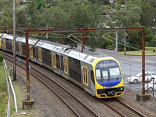
Gosford railway station is located on the Main Northern line in New South Wales, Australia. It serves the Central Coast city of Gosford, opening on 15 August 1887.
Tascott is a suburb of the Central Coast region of New South Wales, Australia between Gosford and Woy Woy on Brisbane Water's western shore. It is part of the Central Coast Council local government area.
The Central Coast Division of Country Rugby League is a rugby league competition based on the Central Coast of New South Wales between Sydney and Newcastle. The competition was founded in 1947 as a junior competition for the Newcastle club, Lakes United. The competition rapidly expanded and grew, so much so that in 1967, it was upgraded to full membership of the Country Rugby League as Group 12. In 1981, it was upgraded and renamed Central Coast Division. The division covers the entire region of the Central Coast from Woy Woy and Umina in the south up to Budgewoi and Gwandalan in the north.
The Wyong Rugby League Football Club are an Australian rugby league club based on the Central Coast of New South Wales. The club competed in the New South Wales Cup from 2013 to 2018 and still competes in the Central Coast Division Rugby League. The club's colours are green and gold, the home ground of the club is the Morry Breen Oval in Kanwal, New South Wales.
The Ourimbah Wyoming Magpies are an Australian rugby league football club based in the suburb of Ourimbah on the Central Coast of NSW. They have numerous teams competing in competitions run by the Central Coast Division of Country Rugby League, from U/7s through to First Grade. The Magpies' current home ground is Bill Sohier Park and their traditional colours are black and white.
The Central Coast Council is a local government area in the Central Coast region of New South Wales, Australia. It is adjacent to the Pacific Highway, Central Coast Highway, the Northern railway line and the Pacific Ocean. The council was formed on 12 May 2016 following the merger of the City of Gosford and Wyong Shire Councils.
This article provides information on the Reserve Grade, Second Grade or B Grade Grand Finals of Rugby League competitions held on the Central Coast of New South Wales, Australia. The Match Details sub-section details the individual point-scorers in a match, where known.
This article provides information on the First Grade or A Grade premiership deciders of Rugby League competitions held on the Central Coast of New South Wales, Australia. The Match Details sub-section details the individual point-scorers in a match, where known. That section shall be expanded upon in the near future.
This article provides information on the under-16 premiership deciders of rugby league competitions held on the Central Coast of New South Wales, Australia. The match details sub-section details the individual point-scorers in a match, where known. In 1996 and all but one season since 2003, a second tier under-16 competition has also been held.
This article provides information on the under 16 premiership deciders of rugbyleague competitions held on the Central Coast of New South Wales, Australia. The match details sub-section details the individual point-scorers in a match, where known.
This article provides information on the under 18 premiership deciders of rugby league competitions held on the Central Coast of New South Wales, Australia. The match details sub-section details the individual point-scorers in a match, where known.
This article provides information on the under 19 premiership deciders of rugby league competitions held on the Central Coast of New South Wales, Australia. The match details sub-section details the individual point-scorers in a match, where known.
The Shire of Woy Woy was a local government area on the Central Coast region of New South Wales, Australia, centred on the town of Woy Woy. The shire was proclaimed on 1 August 1928 as a result of the proclamation of the separation of the D Riding of Erina Shire and had its council seat at Woy Woy, but covered the majority of the Woy Woy peninsula including Woy Woy Bay, Umina, Blackwall, Kariong, Pearl Beach, and Patonga. Woy Woy Shire was abolished on 1 January 1947 with the reorganisation of local government in the Central Coast region following the end of the Second World War, with the council area amalgamated into Gosford Shire.
Rock Davis (1833-1904) was a shipbuilder, mainly associated with his shipyard, the Rock Davis shipyard, colloquially known as 'the Big Shed', on Brisbane Water at Blackwall, New South Wales, Australia. After his death, the business of ship building was carried on by his second son, also Rock Davis. The shipyard constructed around 165 wooden-hulled vessels, between 1862 and 1913.