Localities around Woy Woy: | ||
Phegans Bay | Koolewong | Saratoga |
Horsfield Bay | Woy Woy | St Huberts Island |
Brisbane Water National Park | Umina Beach | Blackwall |
Woy Woy is a coastal town in the Central Coast region of the New South Wales state of Australia. The town is located on the southern reaches of Brisbane Water and near the mouth of Brisbane Water at the Pacific Ocean, it is a popular holiday destination. Woy Woy is located 84 km (52 mi) north of the state capital Sydney. It is a population centre within the Central Coast Council local government area.
Woy Woy is located in the northern half of the Woy Woy Peninsula, a densely populated estuarine peninsula that also includes the districts of Umina Beach, Ettalong Beach, Booker Bay and Blackwall, in addition to several small sub-districts. [2] The Woy Woy Peninsula is the most populous area of the Central Coast. The historical and commercial core of Woy Woy is located around the railway station at the northern tip of the peninsula while its residential districts merge imperceptibly southwards with Umina and Ettalong. (Woy Woy officially ends at Veron Road and Gallipoli Avenue; and Umina begins beyond this).
The double name is a corruption of the indigenous term apparently taken from the local Darkinjung Aboriginal people, and reputedly means 'big lagoon' or 'much water', referring to the deep tidal channel adjacent to the town centre. [3] It was originally known as Webb's Flat, named for James Webb, the first European settler of the Brisbane Water region in 1823, and was first explored by a party led by Governor Arthur Phillip in 1789. [4]
In 1889, after the construction of the Hawkesbury River railway bridge, holidaymakers began to arrive in Woy Woy.[ citation needed ] As of this day, it remains a popular holiday destination.
Electrification of the Main Northern railway line running through Woy Woy to Gosford in 1960 prompted rapid residential development in and around Woy Woy in the 1960s and 1970s as its relatively low-priced properties with rail journey times of just over an hour and a half to reach Sydney or Newcastle.[ citation needed ]
In December 1948, there were private enterprise plans announced to develop 1259 acres of light industrial land, 800 acres of accompanying housing, a railway connection with the existing main line and the conversion of the World War II era airstrip at Ettalong Beach into an airport. If the concept had proceeded all costs would have been covered by the developer, including water, sewerage and other amenities. At the time it was predicted that up to 50,000 jobs would have been developed within 10 to 25 years. [5]
The $24 million Peninsula Leisure Centre opened on 29 October 2005 after significant delays.[ citation needed ]
After their emigration to Australia, Woy Woy became the hometown of the parents of comedian Spike Milligan, who in turn became a frequent visitor to the town and at one point described it as the "world's only above-ground cemetery". [6]
Woy Woy has a number of heritage-listed sites, including:
Year | Pop. | ±% |
---|---|---|
2001 | 9,891 | — |
2006 | 9,985 | +1.0% |
2011 | 10,114 | +1.3% |
2016 | 10,643 | +5.2% |
2021 | 11,072 | +4.0% |
According to the 2021 census, there were 11,072 people in Woy Woy.
Woy Woy has one Catholic school, St John the Baptist Primary School, located in Dulkara Road, Woy Woy. Schooling offered by the Sisters of St. Joseph commenced in Woy Woy in 1922 at the original St John the Baptist Church (Parish hall since 2007) located on the corner of Blackwall and Victoria Roads, Woy Woy. [9] [10] There are also two public primary schools, Woy Woy South and Woy Woy, with the senior campus of Brisbane Water Secondary College also located within Woy Woy.
Perched along the southern waterways of Brisbane Water, Woy Woy is a charming subtropical holiday destination. It includes a variety of endless water views and waterfront dining.[ citation needed ]
Woy Woy comprises 34,000 square metres of commercially zoned land of which 60% consists of retail businesses together with a mix of professional services and major supermarkets including Deepwater Plaza and Peninsula Plaza. Woy Woy represents the commercial heart of the Peninsula and vital commuter transport hub. The town centre is enhanced by the Woy Woy waterfront precinct and Woy Woy Channel with ferry links to Davistown and Empire Bay.
The Woy Woy commercial centre is represented by the Peninsula Chamber of Commerce which is an affiliated member of the NSW Business Chamber. Woy Woy is recognised as the commercial hub of the Peninsula accommodating numerous legal practices, medical centres, banks and professionals. It is largely focused around the Woy Woy Rail Station (major transport hub) and bus interchange with a heavy retail concentration at Deepwater Plaza shopping centre on western edge of the commercial centre and Peninsula Plaza adjacent to the heritage listed Woy Woy Library. Small cafés and restaurants have clustered along the Woy Woy waterfront adjacent to the heritage listed Bayview Hotel and Woy Woy Hotel on Brickwharf Road. The traditional main street (Blackwall Road) has struggled in recent years from pressure from the major shopping centres and the resurgence of the thriving Umina Beach town centre.
An annual Brisbane Water Oyster Festival is held on the first Sunday in November at Ettalong Beach after being relocated from the Woy Woy waterfront in 2005 due to space restrictions. The event outgrew the location with over 20,000 people attending annually. The "Brisbane Water" Oyster Festival was inaugurated in 2000 and is organised by the Peninsula Chamber of Commerce. [11]
The Woy Woy Little Theatre Company [12] perform four plays every year at The Peninsula Theatre, the sister theatre to Laycock Street Theatre in Gosford. Performances are generally based on strict plays rather than devised or improvised theatre forms and have been doing so since 1962. [13]
After their retirement, the parents and younger brother of comedian Spike Milligan (1918–2002) moved to Woy Woy; as a result, Spike spent some time in the town and was occasionally jocularly referred to as "the boy from Woy Woy". Woy Woy was the home to the now defunct festival known as "Spike Fest", which celebrated Milligan's life and works. Milligan famously named Woy Woy "the largest above ground cemetery in the world" when visiting in the 1960s. He made numerous references to Woy Woy in the radio series The Idiot Weekly .
In July 2007, a new cycle bridge near Woy Woy was named the "Spike Milligan Bridge". [14]
Another internationally known resident of Woy Woy was Olive Riley (1899–2008), of the Woy Woy Community Nursing Home, who became recognised as the world's oldest known blogger. [15] From February 2007, aged 107, she started an internet blog and also appeared in a number of YouTube videos. [16] Her last post was made on 26 June 2008, two and a half weeks prior to her death on 12 July, aged 108. [17]
Woy Woy is also home to several sporting teams which compete in Central Coast competitions, including the Roosters (rugby league - competed in Sydney's Jim Beam Cup, but not any more), Sharks (cricket), Woy Woy FC (since 1965) (football), Lions (rugby union) and the Peninsula Swans (Australian rules). Woy Woy is also home to the Woy Woy Tennis Club, one of the oldest Tennis clubs on the Central Coast.
Woy Woy railway station is on the NSW TrainLink network. It is a major commuter hub which moves significant numbers of local workers into Sydney and Newcastle each day. The station is also a major bus interchange with Busways services connecting Woy Woy with other Peninsula centres including Umina Beach and Ettalong Beach. Central Coast Ferries services also operate from the Woy Woy wharf connecting with villages around Brisbane Water including Davistown. Busways also operates 10 bus routes through Woy Woy to its surrounding suburbs.
Gosford is a waterfront city at the northern end of Brisbane Water on the Central Coast in the state of New South Wales, Australia. The Gosford Waterfront is known for its boating and scenic views on the shores of Brisbane Water. Gosford is the main commercial hub and gateway of the Central Coast. It is situated approximately 77 km (48 mi) north of Sydney and 86 km (53 mi) south of Newcastle. Gosford is located in the local government area of the Central Coast Council.
The Central Coast is a peri-urban region lying on the Pacific Ocean in northern-eastern New South Wales, Australia. The region is situated north of Sydney, which is filled with subtropical national parks, forests and also encompasses the major coastal waterways of Brisbane Water, Tuggerah Lakes and southern Lake Macquarie. The region's hinterland, which has fertile valleys, rural farmland and wineries, and also includes the Watagan Mountains. The Central Coast is known for its regional coastal towns like Terrigal, The Entrance, Ettalong Beach, Budgewoi and Bateau Bay with resorts and holiday parks, which feature many expansive beaches and lagoons with surfing and coastal tracks, as well as scenic views. Gosford is the main commercial hub and gateway.
Brisbane Water is a wave-dominated barrier estuary located in the Central Coast region of New South Wales, Australia. Brisbane Water has its origin at the confluence of the Narara and Coorumbine Creeks, to the south–east of Gosford and travels for approximately 18 kilometres (11 mi) in a southerly direction to its mouth at Broken Bay, about 7 kilometres (4.3 mi) from the Tasman Sea, at Barrenjoey Head. A number of towns and suburbs surround the shores of Brisbane Water, including Blackwall, Booker Bay, Davistown, Empire Bay, Erina, Ettalong Beach, Gosford, Green Point, Hardys Bay, Kilcare, Kincumber, Koolewong, Phegans Bay, Point Frederick, Point Clare, Saratoga, Tascott, Wagstaffe, and Woy Woy. Contained within Brisbane Water is St Huberts Island, Rileys Island, Dunmar Island and Pelican Island; and adjoining the estuary is Brisbane Water National Park to the west and Bouddi National Park to the east. Forming part of the same tidal estuary system is a separate but connected basin, the Kincumber Broadwater, lying to the east of Davistown.
The City of Gosford was a local government area that was located in the Central Coast region in the state of New South Wales, Australia. The incorporation of Gosford dates back to 1886 when the Town of Gosford was proclaimed as the Borough of Gosford, becoming the Municipality of Gosford from 1906. In 1908, the Gosford Municipality merged into Erina Shire which covered the remaining Central Coast area outside of Gosford, but regained its independence in 1936. From 1 January 1947, local government in the Central Coast region was reorganised, creating Gosford Shire and Wyong Shire, and the final boundaries of Gosford City Council date from this period. From 1 January 1980, Gosford Shire was granted city status, becoming the City of Gosford. On 12 May 2016 the Minister for Local Government amalgamated the City of Gosford and Wyong Shire Councils to form the new Central Coast Council.
Woy Woy railway station is located on the Main Northern line in New South Wales, Australia. It serves the southern Central Coast town of Woy Woy and opened on 1 February 1889.
Umina Beach is a suburb within the Central Coast Council local government area on the Central Coast of New South Wales, Australia. Umina Beach is situated 85 kilometres (53 mi) north of Sydney and 111 kilometres (69 mi) south of Newcastle.
Gosford railway station is located on the Main Northern line in New South Wales, Australia. It serves the Central Coast city of Gosford, opening on 15 August 1887.
Gosford is an electoral district of the New South Wales Legislative Assembly in Australia. The electorate covers the southern and western parts of the Central Coast Council in the Central Coast region, including central Gosford and Woy Woy.
Ettalong Beach is a suburb of the Central Coast region of New South Wales, Australia south of Woy Woy on Brisbane Water at the point where it meets Broken Bay, about 86 km north of Sydney. It is part of the Central Coast Council local government area. Ettalong Beach is the natural eastward continuation of Umina Beach and Ocean Beach. The village is serviced by a small retail centre along Ocean View Road.
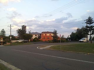
Koolewong is a suburb of the Central Coast region of New South Wales, Australia between Gosford and Woy Woy, and is mostly on a hill overlooking Brisbane Water. It is part of the Central Coast Council local government area.
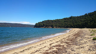
Patonga is a small beach side fishing and holiday village which is part of the Central Coast region of New South Wales, Australia, located on the edge of Brisk Bay and near the mouth of the Hawkesbury River. It is part of the Central Coast Council local government area. Patonga is the southern most village of the Central Coast.
Pearl Beach is a suburb of Central Coast Council on the Central Coast of New South Wales, Australia. Pearl Beach was assigned 'suburb' status by the Geographical Names Board of NSW on 25 October 1991.
The Rugby League Central Coast is a rugby league competition based on the Central Coast of New South Wales between Sydney and Newcastle. The competition was founded in 1947 as a junior competition for the Newcastle club, Lakes United. The competition rapidly expanded and grew, so much so that in 1967, it was upgraded to full membership of the Country Rugby League as Group 12. In 1981, it was upgraded and renamed Central Coast Division. The division covers the entire region of the Central Coast from Woy Woy and Umina in the south up to Budgewoi and Gwandalan in the north. In 2023, CCDRL and CCDJRL merged under one banner to become Rugby League Central Coast. Senior Competition - RLCC, Junior Competition - RLCCJ
Brisbane Water Secondary College is a dual-campus government-funded co-educational comprehensive secondary day school, located on the Central Coast of New South Wales, Australia. The college's Middle School campus is located in Umina Beach, catering for students from Year 7 to Year 9; and the college's Senior Campus is located in Woy Woy, catering from students from Year 10 to Year 12.
Central Coast Ferries is an Australian ferry operator on the Central Coast of New South Wales.
The Umina Beach Bunnies is a rugby league club based on the Central Coast, New South Wales region of Australia.
The Central Coast Council is a local government area in the Central Coast region of New South Wales, Australia. It is adjacent to the Pacific Highway, Central Coast Highway, the Northern railway line and the Pacific Ocean. The council was formed on 12 May 2016 following the merger of the City of Gosford and Wyong Shire Councils.
The Shire of Woy Woy was a local government area on the Central Coast region of New South Wales, Australia, centred on the town of Woy Woy. The shire was proclaimed on 1 August 1928 as a result of the proclamation of the separation of the D Riding of Erina Shire and had its council seat at Woy Woy, but covered the majority of the Woy Woy peninsula including Woy Woy Bay, Umina, Blackwall, Kariong, Pearl Beach, and Patonga. Woy Woy Shire was abolished on 1 January 1947 with the reorganisation of local government in the Central Coast region following the end of the Second World War, with the council area amalgamated into Gosford Shire.
Rock Davis (1833-1904) was a shipbuilder, mainly associated with his shipyard, the Rock Davis shipyard, colloquially known as 'the Big Shed', on Brisbane Water at Blackwall, New South Wales, Australia. After his death, the business of ship building was carried on by his second son, also Rock Davis. The shipyard constructed around 165 wooden-hulled vessels, between 1862 and 1913.