Related Research Articles
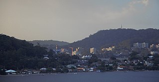
Gosford is a waterfront city on the northern extremity of Brisbane Water in the Central Coast Council local government area in the heart of the Central Coast in New South Wales, Australia. Gosford is known for sailing and boating as well as scenic views on the foreshore of Brisbane Water and some of the surrounding valleys. It is situated 77 km (48 mi) north of Sydney and 86 km (53 mi) south of Newcastle. Gosford is the administrative and commercial centre as well as the gateway of the Central Coast.

The Central Coast is a peri-urban region lying on the Pacific Ocean in northern-eastern New South Wales, Australia. The region is situated north of Sydney, which is filled with subtropical national parks, forests and also encompasses the coastal waterways of Brisbane Water, Tuggerah Lakes and southern Lake Macquarie. The region’s hinterland which has fertile valleys, rural farmland and wineries, which also includes the Watagan Mountains. The Central Coast is known for its regional coastal towns like Terrigal, The Entrance, Ettalong Beach, Budgewoi and Bateau Bay with resorts and holiday parks, which does feature many expansive beaches and lagoons with surfing and coastal tracks, as well as scenic views. Gosford is the main commercial centre and gateway.

Brisbane Water is a wave-dominated barrier estuary located in the Central Coast region of New South Wales, Australia. Brisbane Water has its origin at the confluence of the Narara and Coorumbine Creeks, to the south–east of Gosford and travels for approximately 18 kilometres (11 mi) in a southerly direction to its mouth at Broken Bay, about 7 kilometres (4.3 mi) from the Tasman Sea, at Barrenjoey Head. A number of towns and suburbs surround the shores of Brisbane Water, including Blackwall, Booker Bay, Davistown, Empire Bay, Erina, Ettalong Beach, Gosford, Green Point, Hardys Bay, Kilcare, Kincumber, Koolewong, Phegans Bay, Point Frederick, Point Clare, Saratoga, Tascott, Wagstaffe, and Woy Woy. Contained within Brisbane Water is St Huberts Island, Rileys Island, Dunmar Island and Pelican Island; and adjoining the estuary is Brisbane Water National Park to the west and Bouddi National Park to the east. Forming part of the same tidal estuary system is a separate but connected basin, the Kincumber Broadwater, lying to the east of Davistown.

The City of Gosford was a local government area that was located in the Central Coast region in the state of New South Wales, Australia. The incorporation of Gosford dates back to 1886 when the Town of Gosford was proclaimed as the Borough of Gosford, becoming the Municipality of Gosford from 1906. In 1908, the Gosford Municipality merged into Erina Shire which covered the remaining Central Coast area outside of Gosford, but regained its independence in 1936. From 1 January 1947, local government in the Central Coast region was reorganised, creating Gosford Shire and Wyong Shire, and the final boundaries of Gosford City Council date from this period. From 1 January 1980, Gosford Shire was granted city status, becoming the City of Gosford. On 12 May 2016 the Minister for Local Government amalgamated the City of Gosford and Wyong Shire Councils. The Central Coast Council was established on the same day, covering the combined areas.
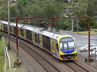
The Central Coast & Newcastle Line is a NSW TrainLink passenger train service that runs along the Main North railway line in New South Wales, connecting the state's two largest cities, Sydney and Newcastle. The service runs from Central through to Broadmeadow on the Main North railway line to Newcastle Interchange on the Newcastle railway line, and services the Hawkesbury River region, the Central Coast and the city of Newcastle.

Woy Woy railway station is located on the Main Northern line in New South Wales, Australia. It serves the southern Central Coast suburb of Woy Woy opening on 1 February 1889.

Point Clare railway station is located on the Main Northern line in New South Wales, Australia. It serves the southern Central Coast suburb of Point Clare opening on 28 June 1891.

Woy Woy is a coastal town in the Central Coast region of New South Wales, Australia, located on the southern reaches of Brisbane Water 79 km (49 mi) north of Sydney. It is a population centre within the Central Coast Council local government area.
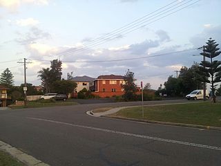
Umina Beach is a suburb within the Central Coast Council local government area on the Central Coast of New South Wales, Australia. By road, it is 85 kilometres (53 mi) north of the Sydney CBD and 111 kilometres (69 mi) south of the Newcastle CBD.

Gosford railway station is located on the Main Northern line in New South Wales, Australia. It serves the Central Coast city of Gosford, opening on 15 August 1887.

Red Bus Services is an Australian bus company operating route bus services on the New South Wales Central Coast.

Busways is an Australian bus company operating services in Sydney, and in the Central Coast, Great Lakes, Mid North Coast regions of New South Wales and Adelaide. It is the largest privately owned bus operator in Australia.

Empire Bay is a suburb on the Central Coast of New South Wales, Australia. It is part of the Central Coast Council local government area.

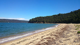
Ettalong Beach is a suburb of the Central Coast region of New South Wales, Australia south of Woy Woy on Brisbane Water at the point where it meets Broken Bay, about 86 km north of Sydney. It is part of the Central Coast Council local government area. Ettalong Beach is the natural eastward continuation of Umina Beach and Ocean Beach. The village is serviced by a small retail centre along Ocean View Road.
Patonga is a suburb of the Central Coast region of New South Wales, Australia, located on the north bank of the Hawkesbury River, southwest of Woy Woy. It is part of the Central Coast Council local government area.

Pearl Beach is a suburb of Central Coast Council on the Central Coast of New South Wales, Australia. Pearl Beach was assigned 'suburb' status by the Geographical Names Board of NSW on 25 October 1991.

St Huberts Island is a canal estate and suburb of the Central Coast region of New South Wales, Australia connected to the mainland at Daleys Point. It is part of the Central Coast Council local government area.

The Central Coast Council is a local government area in the Central Coast region of New South Wales, Australia. The area is adjacent to the Pacific Highway, Central Coast Highway and the Northern NSW railway line as well as the Pacific Ocean. The council has over 40 beaches and over 90km of coastline. The Central Coast Council was formed on 12 May 2016 following the merger of the Gosford City and Wyong Shire councils.
The Shire of Woy Woy was a local government area on the Central Coast region of New South Wales, Australia, centred on the town of Woy Woy. The shire was proclaimed on 1 August 1928 as a result of the proclamation of the separation of the D Riding of Erina Shire and had its council seat at Woy Woy, but covered the majority of the Woy Woy peninsula including Woy Woy Bay, Umina, Blackwall, Kariong, Pearl Beach, and Patonga. Woy Woy Shire was abolished on 1 January 1947 with the reorganisation of local government in the Central Coast region following the end of the Second World War, with the council area amalgamated into Gosford Shire.
References
- ↑ Andrews, Graeme (1994). Ferries of Sydney (3rd ed.). Sydney: Sydney University Press. p. 194. ISBN 0424002027.
- ↑ Working on the Central Coast's beautiful waterways is a dream come true for Tim Conway Central Coast Advocate 13 December 2016
- ↑ King tide highlights needs for Woy Woy Public Wharf rebuild Central Coast Advocate 8 December 2017
- ↑ Woy Woy to Empire Bay timetable Archived 1 October 2020 at the Wayback Machine Transport for New South Wales
- ↑ Woy Woy - Ettalong timetable Central Coast Ferries
- ↑ New ferry service to run from Gosford to Patonga from next week Archived 25 July 2016 at the Wayback Machine Central Coast Advocate 19 May 2016
- ↑ Gosford to Patonga Ferry Archived 10 March 2018 at the Wayback Machine Central Coast Ferries
- ↑ Our Fleet Archived 22 March 2018 at the Wayback Machine Central Coast Ferries
| |
| ||||
|---|---|---|---|---|---|
| | |||||
| |
| ||||
| | |||||
| Other | |||||